On this day in 1846, Congress passed legislation to return Alexandria, which was then a part of the District of Columbia, to its rightful place in the Commonwealth of Virginia. (The legislation also returned Arlington, but that’s clearly of no interest.)
Reminders of Alexandria’s retrocession from DC can be found when running through Jones Point at the southern tip of the city – where the original borders of DC are now literally carved in stone – and just walking through Old Town, where often-overlooked relics of Alexandria’s past can be found if you know what you’re looking for, and where to look.
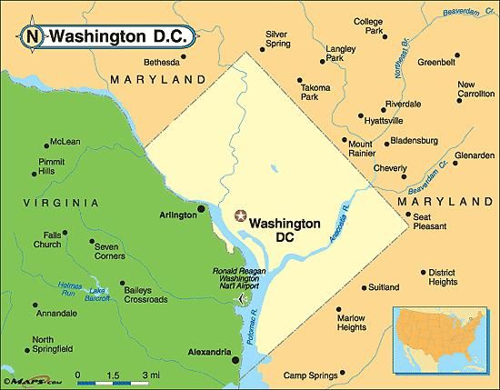
The District of Columbia’s borders were meant to create a perfect diamond, carved out of Maryland and Virginia and centered on the Potomac River:

Thanks to legislation passed in Congress 171 years ago today, DC’s borders took on a more familiar shape, courtesy of Alexandria’s Retrocession to the Commonwealth:

You can get the full details of this glorious return of Alexandria (and much less interesting Arlington) to the Commonwealth on Wikipedia, a really good WETA blog, or this site on DC’s boundary stones.
The short version is that the port city of Alexandria assumed that becoming part of the capital would result in an economic boom, including serving as the location of some government offices and other business activities in support of the new federal government. None of this happened. Not only did DC fail to invest in Alexandria, but construction of federal buildings for the new capital were restricted to the east side of the Potomac River. As an even greater affront to our bustling port town, shipping traffic was routed increasingly to DC’s Georgetown, to the detriment of Alexandria.
Alexandria wanted out. And, on this day in 1846, Congress agreed.
More than 170 years later, at least three traces of Alexandria’s legacy as a part of the original District still remain. Some from the 18th century, others from the 19th, and the last from just a few years ago.
Boundary stones. The oldest signs of the city’s past as part of the District can be found on Jones Point, then heading in a straight line due northwest from the light house. The boundary stones that originally delineated the border between DC and Virginia. From boundarystones.org: “Acting on instructions from Secretary of State Thomas Jefferson, Major Andrew Ellicott began his initial observations for a rough survey of the ten-mile square on Friday, February 11, 1791. Ellicott, a prominent professional surveyor, hired Benjamin Banneker, an astronomer and surveyor from Maryland, to make the astronomical observations and calculations necessary to establish the south corner of the square at Jones Point in Alexandria. . . On April 15, 1791, the Alexandria Masonic Lodge placed a small stone at the south corner at Jones Point in ceremonies attended by Ellicott, federal district commissioners Daniel Carroll and David Stuart, and other dignitaries. George Washington did not attend the ceremony, although he did visit the site the prior month. Newpapers around the country announced the story of the beginning of the new federal city. (In 1794, the ceremonial stone at Jones Point was replaced by a large stone, still in place today, with the inscription “The beginning of the Territory of Columbia” on one side.)”
Approaching Jones Point Light House from the pylons marking the old Virginia / District of Columbia border under the Woodrow Wilson Bridge (we’ll get to the pylons later):


Historical plaque outside of the lighthouse with more details:

Good stuff on the origin and retrocession:

And a new one to us – we didn’t know that L’Enfant had planned to do something on this side of the river:

Protective enclosure over the stone:

The original boundary stone from 1794 inside the light house sea wall:

Historical marker next to the boundary stone:

The boundary stone exposed during maintenance in March 2020. From boundarystone.org: “On April 15, 1791, the Alexandria Masonic Lodge placed a small stone at the south corner at Jones Point in ceremonies attended by Ellicott, federal district commissioners Daniel Carroll and David Stuart, and other dignitaries. George Washington did not attend the ceremony, although he did visit the site the prior month. Newpapers around the country announced the story of the beginning of the new federal city. (In 1794, the ceremonial stone at Jones Point was replaced by a large stone, still in place today, with the inscription “The beginning of the Territory of Columbia” on one side.)”
The 1794 stone actually sits so close to the shoreline that it gets flooded at very high tides. Amazing that it’s still there and intact, but it is.

In fact, most of the original boundary stones are still extant:

From boundarystones.org
The second boundary stone lies a mile to the northwest, at the edge of a picket-fenced yard at the corner of Wilkes and South Payne:


Another mile further, is the third boundary stone, on Russell Road, right off of King near the Masonic Temple:


From boundarystone.org: “This is neither the original stone nor the original location. Baker and Woodward reported the original stone to be missing as of the late 1800s, and DAR records show that the current stone was placed at this location in 1920. The original stone was located about 0.35 northwest of this replacement. According to Woodward, the original “stone was evidently placed on the east side, and very close to, [King Street], on the eastern side of Shuter’s Hill, in a subdivision” now called Rosemont.”
We’re sure boundarystones.org is correct, but this conflicts directly with the first word on the plaque affixed to the protective cage:

The third boundary stone is located a mile down King Street, in the parking lot of the First Baptist Church on King Street near TC Williams:


Downspouts. The absolute coolest of these leftovers are cast iron downspouts manufactured before 1846, which are embossed with “Alexandria, DC.” Part of the attraction is the legacy, in iron, of Alexandria’s past:

The other part is the scavenger hunt aspect to spotting these artifacts. They only seem to be located in the southeast quadrant of town, and we’ve only located three. Two are located near the intersection of Prince and South Fairfax; the other is on the 300 block of South Lee.


Presumably after the retrocession, the same iron works, TW&RC Smith, continued fabrication of wrought iron downspouts of the same design, but just updated the “ALEXANDRIA, DC” to “ALEXANDRIA, VA.” An example of this later generation of downspout also can be found right across the street from a DC version, near the Prince and Fairfax intersection:


Border pylons. Thanks to frequent morning runs under the Woodrow Wilson Bridge and through Jones Point Park, the third legacy of Alexandria’s old DC borders are hard to miss. Jones Point is located at the southern tip of Alexandria and of what was, prior to retrocession, the District:

During construction of the new bridge and restoration and renewal activities at the park, the Park Service installed granite pylons marking the original borders of Alexandria, DC.


As a result, you get to run through the old borders, into what was once DC – and into Maryland. The border between Maryland and Virginia is the low-water mark of the Potomac River. Due to infill by Alexandria over the centuries, the river edge has moved gradually east, stranding the original Maryland / Virginia border at Jones Point on dry land.

Although the recently erected granite pylons at Jones Point are not original, the southernmost boundary stone entombed in the Jones Point Light House sea wall is. Happy 268th Birthday, Alexandria, and happy 171st Retrocession Day!