Maps and Miscellany

The Abandoned Rodman Guns of Fort Foote

So, we were supposed to be publishing posts from our Edinburgh trip this weekend (as well as a bunch of other backlogged posts), but it’s too much work right now.

However, after a ride today over the Woodrow Wilson Bridge into Prince Georges County, we thought this may be interesting to share instead. All of the quoted information below is from this helpful National Park Service site.

Fort Foote was one of 68 ring forts constructed during the Civil War to protect the capital city from Confederate attack. It’s still around, but is well and truly hidden. Seriously. We grew up in the area, are well aware of Fort Hunt on our side of the Potomac and the massive Fort Washington on the opposite shore, and had never heard of Fort Foote. It took the 2008 opening of the Woodrow Wilson Bridge replacement – with outstanding pedestrian and bike infrastructure to reach Prince Georges County – to make us aware of its existence. Even with this revelation, it’s still jarring to wander through the overgrown site, turn a corner, and stumble upon the massive abandoned Rodman guns.

Some background on Fort Foote from the Park Service:

“In 1862 the battle between the Monitor and Merrimac, at Hampton Roads, created panic in Washington. As the war progressed, many European countries seemed eager to join the fight on the side of the Confederacy. Fort Washington, on the Potomac River 16 miles below Washington was considered too far away to be adequately supported. Therefore the protection of the city from naval attack became a major concern and army engineers began building earthworks to resist naval bombardment.”

“In the words of General Barnard they were “in many respects, model works. Fort Foote was constructed for the purpose of defending, in connection with Battery Rogers, the water approach to the city.”

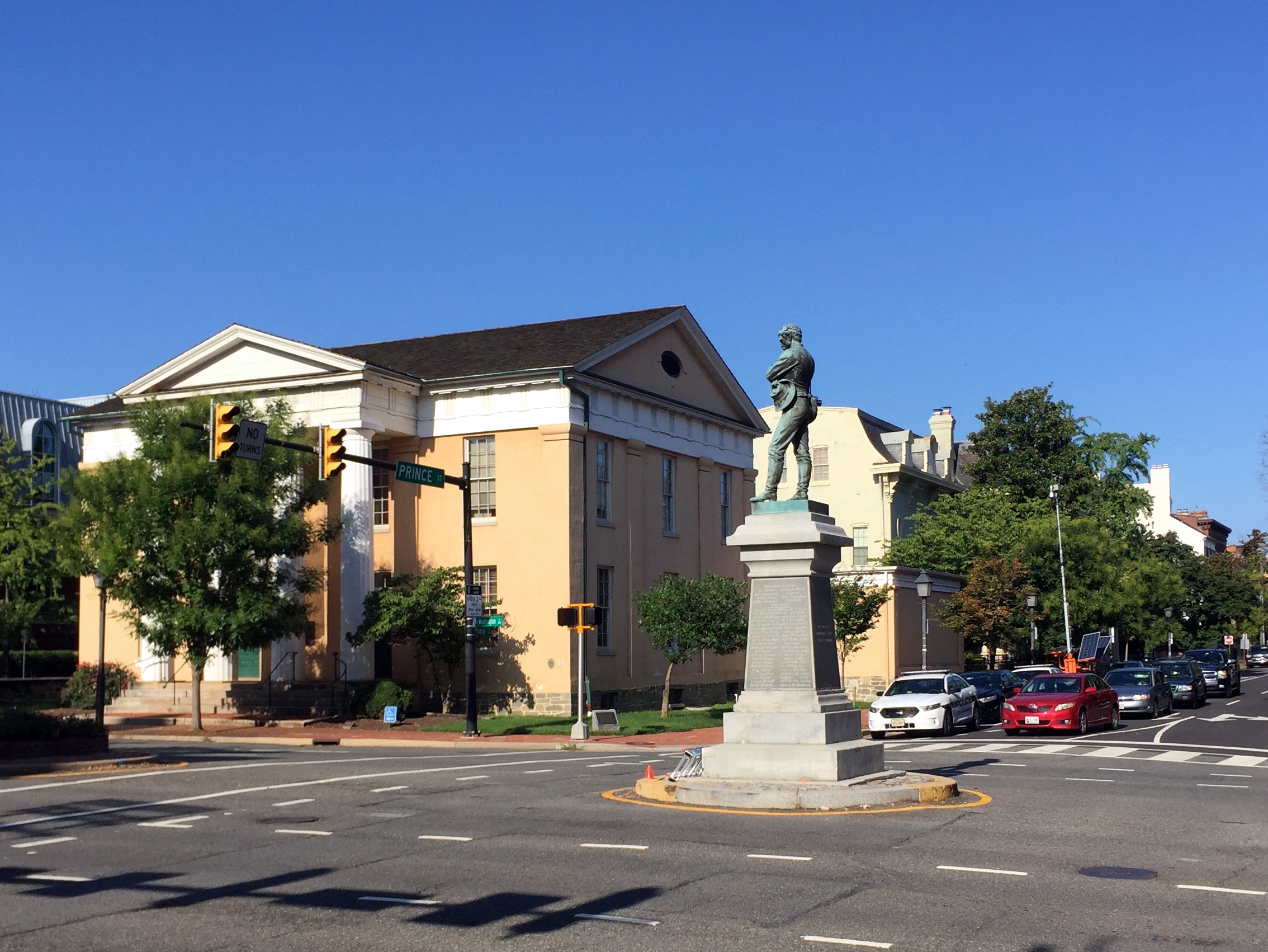
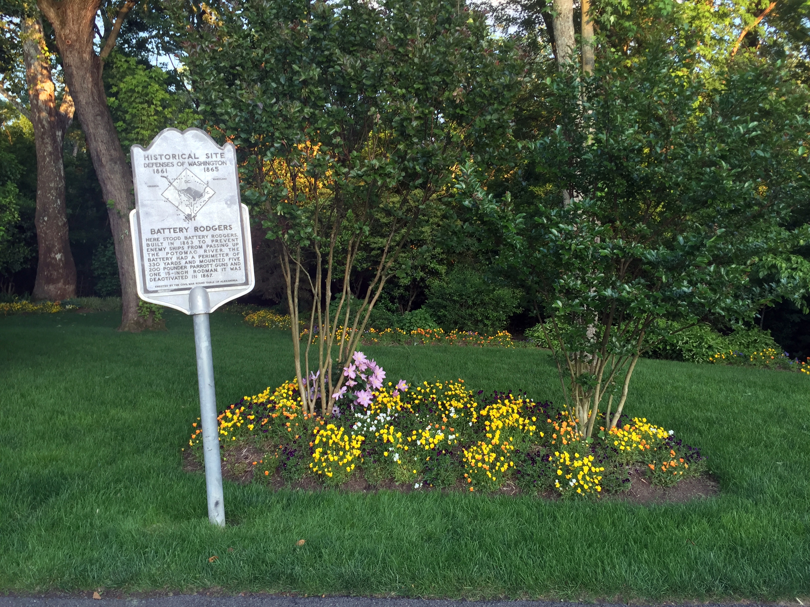
Battery Rodgers, as it happens, is just a few blocks away from us in Old Town – there’s a historical marker on the 800 block of South Lee Street, just a little west of where the battery stood during the Civil War.

“Fort Foote was situated six miles below Washington,on a commanding bluff of the Maryland shore, elevated 100 feet above the river. The fort was essentially completed in the fall of 1863, and was designed as a water battery of eight 200-pounder Parrott rifles and two 15-inch guns.”

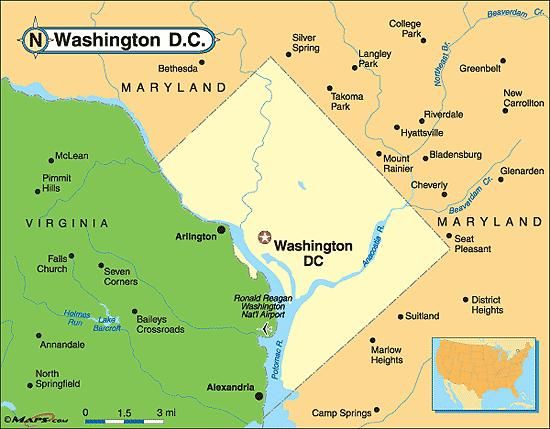
Location of Fort Foote (and Battery Rodgers):

Location Satellite

The Saturday in May 2008 that the new bridge and bike lane opened, one of us headed across to explore, with Fort Washington as the destination for the ride. On the way, right on the curve of Fort Foote Road, was an unassuming sign in a field by an empty gravel parking lot.

There only signage in the park is a hundred yards into the woods, where there’s barely a trail to follow:

Even from this location, there was no fort or guns to be seen. Only a long berm, overgrown with bushes and saplings. This turned out to be the remains of one of the earthworks.

Beyond, lay one of the guns:

Some background on Fort Foote’s firepower during the Civil War from the Park Service site: “The first 15-inch gun arrived in the fall of 1863 and by April 1865 the fort boasted of two 15-inch Rodman Cannons, four 200 pounder Parrott Rifles and six 30 pounder Parrott Rifles. The work was declared complete on June 6, 1865. A large crowd of civilian and military observers gathered to watch the guns fire on February 27 and again on April 1, 1864. The 8-inch Parrott Rifles weighed over 8 tons and used 16 pounds of powder to fire its 200-pound projectile 2,000 yards down the river. But the fort’s main attraction was the 15-inch [Rodmans]. They weighed in at 25 tons and required 300 to 400 soldiers to move them up the bluff from the river. Forty pounds of powder could send a 440-pound round-shot over 5,000 yards.”

It’s difficult to convey how truly huge these mothers are without some perspective, even from a shot this close:

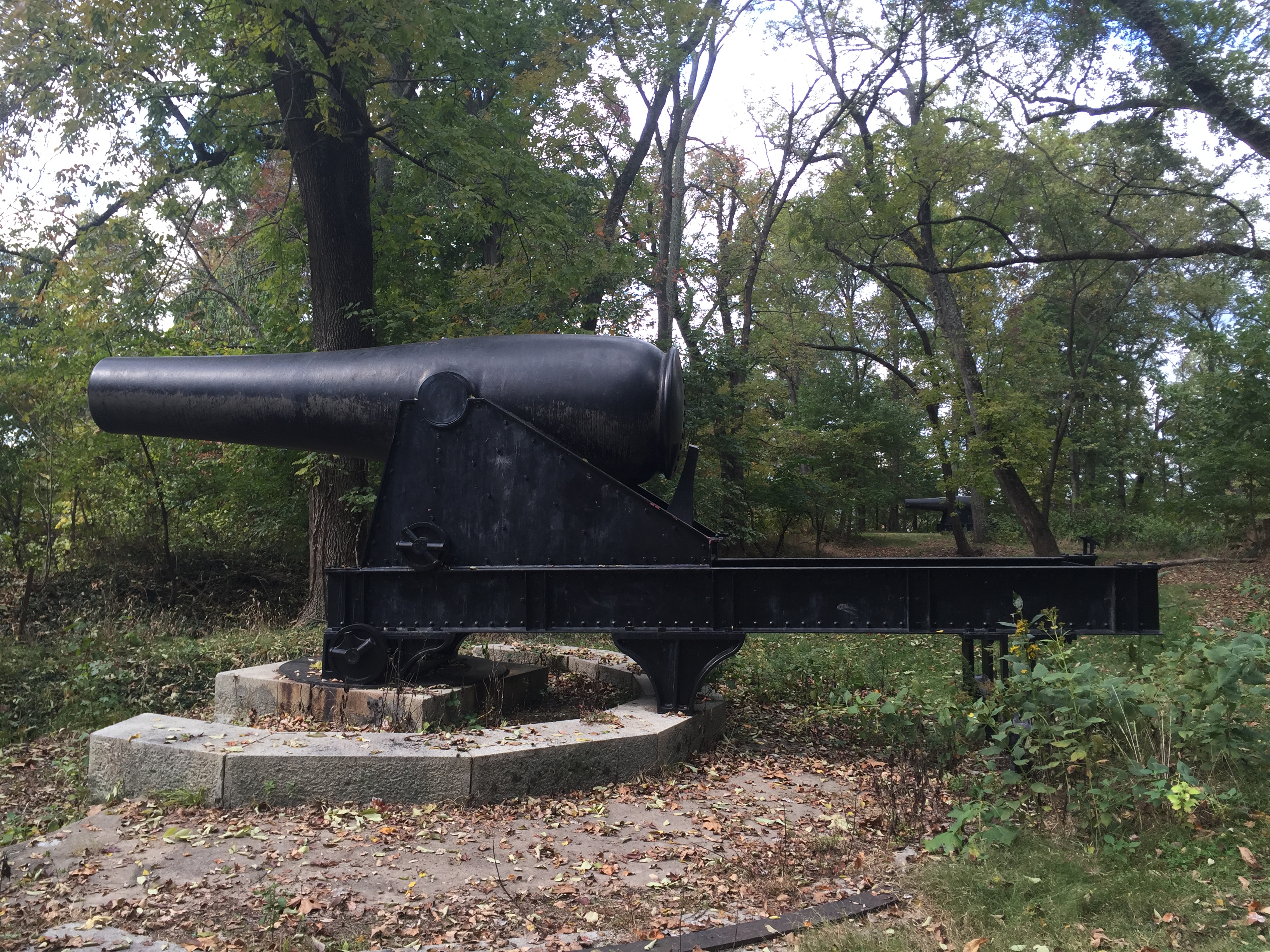
So, some perspective:

The guns are massive, and they’re basically just abandoned in the woods. “During the Civil War the 15-inch guns cost the government $9,000 each but they could do major damage to a wood sailing ship-of-war. At close range, even the iron clads were not safe from the massive weapons.”

“During our Civil War most European navies armed their vessels with 9-inch rifled guns. Other technologies such as the screw propeller, steam engine, rotating gun turret and iron-sided ships with watertight compartments were making our seacoast defenses obsolete. Our government could not afford an arms races so it was decided to wait and see how the gun versus ship race progressed before investing in changes. In 1870, the army started an extensive program to modify existing defenses. Inexpensive earthwork batteries were armed with existing smoothbore guns, primarily the 15-inch Rodman. A few guns were mounted but funds were withdrawn in 1875. The Chief of Engineers stated in his 1877 annual report, “Our largest guns, of which we have any number, is a 15-inch smooth-bore, and weighs over 25 ton. We have about 325 of them for our entire coast of 12,600 miles.”

The 15-inch gun was finally tested at Sandy Hook, NJ in 1883. It was found that 130 pounds of black-powder created 25,000 pounds of pressure in the chamber and at 20 degrees elevation the gun could send a 440-pound shell over 3 1/2 miles. At 1,000 yards the round-ball projectile could pierce 10 inches of iron. No warship, regardless of how well armored, could afford to trade shots with a 15-inch Rodman at close range.”

I’ve brought riding partners to the site when they join me for the ride east from Alexandria into PG County, and some have found more creative ways to provide the size context:

If you have 15 minutes to blow after a visit to National Harbor, Fort Foote is worth checking out. Unassuming, overgrown, and with two big ass Rodman guns sitting in a sylvan setting as incongruous reminders of the site’s power for a few years in the 1860s. The now-homely site even hosted some notables during the war:

“The first unit to garrison Fort Foote was four companies of the 9th New York Heavy Artillery that arrived on August 12, 1863. The post was commanded by lieutenant Colonel William H. Seward, Jr., the son of the Secretary of State. The secretary visited the post often while his son was in command and President Lincoln visited the fort on August 20, 1863 with the Secretary of War and number of high-ranking army officers.”

Categories: Alexandria History, Maps and Miscellany, WolfeStreetProject | 3 Comments

18th-Century Ship at the Foot of Wolfe

On Saturday, Alexandria left exposed for 4 hours the hull of an 18th-century ship uncovered during ongoing construction work on the block between Wolfe and Duke on Union. The ship is the largest of three undergoing excavations on the site and one of four discovered in a two-block area along the water; the fourth was encountered 18 months ago during construction of Hotel Indigo a block north.

IMG_7002

Visitors started to gather at noon for the 4-hour viewing period before tarps over the hull were replaced to protect it from degradation due to exposure.

The city’s Acting Archeologist told us during our visit that the ships were likely scuttled in 1798 as part of the city’s efforts to create more land on the waterfront to support warehouses of the port city.

IMG_7004

View of the hull facing north from Wolfe Street; the stone foundation of a 19th-century warehouse (that was buried by a 20th-century warehouse) can be seen at the top of the picture.

The ship is about 46′ by 25′ and had reinforced futtocks (curved timber pieces forming the lower part of a ship’s frame) suggesting that it could have been used to haul military cargo. A bunch of volunteers at the event wore “Save our Futtocks” buttons promoting funding preservation efforts for the ship.

IMG_7028

View of the hull facing west from the waterfront

In addition to scuttling the ships to extend the shoreline, the city also used cribbing – rough boxes created with logs and filled with anything on hand – for the same purpose.

IMG_7051

Exposed cribbing immediately west of the ship hull.

To be clear, this really wasn’t the most exciting find in the world and we were a little underwhelmed by the ship hull itself. That said, it’s great to see these historical remnants of the city’s early period exposed, interpreted, and open to the public during construction of a new development along the water and at the foot of Wolfe Street.

Save our Futtocks!


Categories: Alexandria History, Maps and Miscellany, WolfeStreetProject | 3 Comments

Protected: Act I: Minibar

This content is password-protected. To view it, please enter the password below.

Categories: Maps and Miscellany | Enter your password to view comments.

Mappy Hour: Independent from Spain? One Catalonian Town Already Is (Geographically, at Least)

Events swirling around Catalonia’s lurch toward independence from Spain accelerated rapidly today. Catalonia’s Parliament declared independence and Spain reacted by suspending the region’s government, taking over Catalonia’s police, and calling for December elections.

In the meantime, as the New York Times reported today, the Catalonian town of Llivia has been independent from Spain for 350 years. Geographically, the town is located entirely within France:

The NYT reports that, with regard to independence, “for Llivia, a quaint town tucked about 4,000 feet up in the foothills of the Pyrenees, an important part of that decision was made centuries ago. Llivia is already separated from Spain physically: The five-square-mile municipality is a geographic anomaly resulting from a quirk of the 1659 Treaty of the Pyrenees, which settled a more-than-two-decade round of fighting between Spain and France.

Only “villages,” according to the treaty, were to be ceded to the French crown. Llivia was considered a town, not a village, and so remained part of Spain, and the region of Catalonia.”

Catalonia est non Espana! And, if Catalonia does indeed secede, Llivia won’t be Catalonia (on a map, anyway).

The cartographic coolness never ends.

Categories: Mappy Hour, Maps and Miscellany | 4 Comments

Mappy Hour: Catalonia’s Not the Only European Area Agitating for Autonomy

After an aborted referendum and multiple protests, Catalonia’s president today may or may not have announced that the region will pursue independence (it was so ambiguous that Spain requested that he clarify what he’s actually trying to say). The Washington Post has helpfully published an update on some previous articles they’ve posted on the other restless regions across Europe.

The disappointingly brief article included the usual suspects, including Scotland, Flanders, and the Basque region. However, it also introduced a few we hadn’t known about earlier, including South Tyrol (a German-speaking region in Italy that previously was part of Austria prior to WW I) and the Faroe Islands, who are itching to throw off the distant Danish yoke.

A good quick read if you like European history and geography!

Categories: Mappy Hour, Maps and Miscellany | Leave a comment

Protected: Where Better to Watch the Eclipse?

This content is password-protected. To view it, please enter the password below.

Categories: Maps and Miscellany, Miscellany | Enter your password to view comments.

Is Alexandria’s Appomattox Statue the Next to Fall?

Old Town’s iconic Appomattox statue at the intersection of Washington Street and Prince Street currently is under police protection. Someone tried scaling the statue this morning.

We talked to the cops who were on all four corners of the intersection this morning. All they knew was that someone tried climbing the statue without authorization and were there to prevent further attempts. We assume this is fallout from the jackass alt right march in Charlottesville and the resulting authorized (in Baltimore, for example) and unauthorized (in Durham) removals of Confederate statues in several states.

The ladder used by the climber was still there when we walked by (we assume that’s what it is – when we asked the cops, they said, “All I know is that it’s not ours.”)

The confederate soldier on the monument faces south, his back to the north. A stone historic marker on the southwest corner of the intersection by the Lyceum reads:

“THE CONFEDERATE STATUE

The unarmed Confederate soldier standing in the intersection of Washington and Prince Streets marks the location where units from Alexandria left to join the Confederate Army on May 24, 1861. The soldier is facing the battlefields to the South where his comrades fell during the War Between the States. The names of those Alexandrians who died in service for the Confederacy are inscribed on the base of the statue. The title of the sculpture is “Appomattox” by M. Casper Buberl.

The statue was erected in 1889 by the Robert E. Lee Camp, United Confederate Veterans.”

The north side of the statue’s base reads, “They died in the consciousness of duty faithfully performed.” The south side reads, “Erected to the memory of Confederate dead of Alexandria, Va. by their Surviving Comrades, May 24th 1889.” The east and west sides bear the names of those from Alexandria who died during the Civil War.

In the wake of other recent violent racist events south of Virginia, Alexandria’s City Council voted unanimously last year to move the statue to the Lyceum. However, a Virginia law prohibits the relocation of war memorials, rendering the vote a purely symbolic gesture.

We hope it stays, and that Alexandria’s monument to an aspect of the city’s history doesn’t become yet more collateral damage from the actions of racist morons.

Categories: Alexandria History, Maps and Miscellany, WolfeStreetProject | 4 Comments

Lake Lugano, Switzerland

Day 5 of the micronations road trip took us to a halfway point between Liechtenstein and our next target, the Principality of Monaco. The halfway point we selected was Lake Lugano, Switzerland (which brought our country count for just 5 days of the trip to five, as it happens . . .). GPS route for the day’s drive:

As some have noted, this blog has a particular interest in geography and geographic anomalies. Lake Lugano played to this interest. Although the type of geographical anomaly there is very unusual, we had nonetheless encountered this type of anomaly twice already during the trip: an enclave.

The Italian commune of Campione on Lake Lugano lies entirely inside the Swiss canton of Ticino. The map below shows Swizerland in pink and Lake Lugano in deep blue. The enclaved Italian commune isolated entirely inside of Switzerland is in the southeast section of the lake:

Unlike the enclaves of Vatican City and San Marino, where an entire nation resided inside another country, this enclave represented just a tiny piece of Italy, very similar to the Spanish town (or Catalonian town, if you side with the secessionists there) of Livia stuck inside of France, which we blogged about last year.

Although we’ve only been posting information on why things still exist on the micronation blogs themselves, we figured this enclave deserved some detail, so here’s the explanation for why it exists, courtesy of Wikipedia:

“In the first century BC the Romans founded the garrison town of Campilonum to protect their territories from Helvetii invasions.

In 777, Toto of Campione, a local Lombard lord, left his inheritance to the archbishopric of Milan. Ownership was transferred to the abbey of Sant’Ambrogio. In 1512, the surrounding area of Ticino was transferred from the ownership of the bishop of Como to Switzerland by Pope Julius II, as thanks for support in the War of the Holy League. However, the abbey maintained control over what is now Campione d’Italia and some territory on the western bank of Lake Lugano.

When Ticino chose to become part of the Swiss Confederation in 1798, the people of Campione chose to remain part of Lombardy. In 1800, Ticino proposed exchanging Indemini for Campione. In 1814 a referendum was held, and the residents of Campione opposed it. In 1848, during the wars of Italian unification, Campione petitioned Switzerland for annexation. This was rejected due to the Swiss desire for neutrality.

After Italian unification in 1861, all land west of Lake Lugano and half of the lake were given to Switzerland so that Swiss trade and transport would not have to pass through Italy. The d’Italia was added to the name of Campione in the 1930s by Prime Minister Benito Mussolini and an ornamental gate to the city was built. This was to assert the exclave’s Italian-ness.”

On to our day in Lake Lugano.

First, we definitely picked the right place to stay – spectacular views of the lake:

And a complementary electric Smart Car for forays down to the lake . . .

Along the lake . . .

The Romanesque Church of Santa Maria degli Angeli on the shores of the lake:

The church was built in 1499 in recognition of the cessation of conflict between the Guelphs and Ghibellines and to thank the Observant Franciscans for their work during the plague of 1498. It features a very busy 15th century fresco by a student of Leonardo da Vinci that’s still perfectly intact and considered to be one of the best examples of art during the Lombard Renaissance.

Heading back to The View in our sweet ride:

Incredible dinner outside at The View, overlooking Lake Lugano:


Unbeknownst to us, August 1 is Swiss National Day, so not only did we have a sweet dinner overlooking the lake, but got to experience a great fireworks display, to boot.


Categories: Mappy Hour, Maps and Miscellany, Micronations!, Switzerland | Tags: , , , , , , , | 2 Comments

Mappy Hour: Alexandria, DC

On this day in 1846, Congress passed legislation to return Alexandria, which was then a part of the District of Columbia, to its rightful place in the Commonwealth of Virginia. (The legislation also returned Arlington, but that’s clearly of no interest.)

Reminders of Alexandria’s retrocession from DC can be found when running through Jones Point at the southern tip of the city – where the original borders of DC are now literally carved in stone – and just walking through Old Town, where often-overlooked relics of Alexandria’s past can be found if you know what you’re looking for, and where to look.

The District of Columbia’s borders were meant to create a perfect diamond, carved out of Maryland and Virginia and centered on the Potomac River:

Original Diamond Map of DC

Thanks to legislation passed in Congress 171 years ago today, DC’s borders took on a more familiar shape, courtesy of Alexandria’s Retrocession to the Commonwealth:

You can get the full details of this glorious return of Alexandria (and much less interesting Arlington) to the Commonwealth on Wikipedia, a really good WETA blog, or this site on DC’s boundary stones.

The short version is that the port city of Alexandria assumed that becoming part of the capital would result in an economic boom, including serving as the location of some government offices and other business activities in support of the new federal government. None of this happened. Not only did DC fail to invest in Alexandria, but construction of federal buildings for the new capital were restricted to the east side of the Potomac River. As an even greater affront to our bustling port town, shipping traffic was routed increasingly to DC’s Georgetown, to the detriment of Alexandria.

Alexandria wanted out. And, on this day in 1846, Congress agreed.

More than 170 years later, at least three traces of Alexandria’s legacy as a part of the original District still remain. Some from the 18th century, others from the 19th, and the last from just a few years ago.

Boundary stones. The oldest signs of the city’s past as part of the District can be found on Jones Point, then heading in a straight line due northwest from the light house. The boundary stones that originally delineated the border between DC and Virginia. From boundarystones.org: “Acting on instructions from Secretary of State Thomas Jefferson, Major Andrew Ellicott began his initial observations for a rough survey of the ten-mile square on Friday, February 11, 1791. Ellicott, a prominent professional surveyor, hired Benjamin Banneker, an astronomer and surveyor from Maryland, to make the astronomical observations and calculations necessary to establish the south corner of the square at Jones Point in Alexandria. . . On April 15, 1791, the Alexandria Masonic Lodge placed a small stone at the south corner at Jones Point in ceremonies attended by Ellicott, federal district commissioners Daniel Carroll and David Stuart, and other dignitaries. George Washington did not attend the ceremony, although he did visit the site the prior month. Newpapers around the country announced the story of the beginning of the new federal city. (In 1794, the ceremonial stone at Jones Point was replaced by a large stone, still in place today, with the inscription “The beginning of the Territory of Columbia” on one side.)”

Approaching Jones Point Light House from the pylons marking the old Virginia / District of Columbia border under the Woodrow Wilson Bridge (we’ll get to the pylons later):

Historical plaque outside of the lighthouse with more details:

Good stuff on the origin and retrocession:

And a new one to us – we didn’t know that L’Enfant had planned to do something on this side of the river:

Protective enclosure over the stone:

The original boundary stone from 1794 inside the light house sea wall:

Historical marker next to the boundary stone:

The boundary stone exposed during maintenance in March 2020. From boundarystone.org: “On April 15, 1791, the Alexandria Masonic Lodge placed a small stone at the south corner at Jones Point in ceremonies attended by Ellicott, federal district commissioners Daniel Carroll and David Stuart, and other dignitaries. George Washington did not attend the ceremony, although he did visit the site the prior month. Newpapers around the country announced the story of the beginning of the new federal city. (In 1794, the ceremonial stone at Jones Point was replaced by a large stone, still in place today, with the inscription “The beginning of the Territory of Columbia” on one side.)”

The 1794 stone actually sits so close to the shoreline that it gets flooded at very high tides. Amazing that it’s still there and intact, but it is.

In fact, most of the original boundary stones are still extant:

From boundarystones.org

The second boundary stone lies a mile to the northwest, at the edge of a picket-fenced yard at the corner of Wilkes and South Payne:

Another mile further, is the third boundary stone, on Russell Road, right off of King near the Masonic Temple:

From boundarystone.org: “This is neither the original stone nor the original location. Baker and Woodward reported the original stone to be missing as of the late 1800s, and DAR records show that the current stone was placed at this location in 1920. The original stone was located about 0.35 northwest of this replacement. According to Woodward, the original “stone was evidently placed on the east side, and very close to, [King Street], on the eastern side of Shuter’s Hill, in a subdivision” now called Rosemont.”

We’re sure boundarystones.org is correct, but this conflicts directly with the first word on the plaque affixed to the protective cage:

The third boundary stone is located a mile down King Street, in the parking lot of the First Baptist Church on King Street near TC Williams:

Downspouts. The absolute coolest of these leftovers are cast iron downspouts manufactured before 1846, which are embossed with “Alexandria, DC.” Part of the attraction is the legacy, in iron, of Alexandria’s past:

IMG_6498

The other part is the scavenger hunt aspect to spotting these artifacts. They only seem to be located in the southeast quadrant of town, and we’ve only located three. Two are located near the intersection of Prince and South Fairfax; the other is on the 300 block of South Lee.

Presumably after the retrocession, the same iron works, TW&RC Smith, continued fabrication of wrought iron downspouts of the same design, but just updated the “ALEXANDRIA, DC” to “ALEXANDRIA, VA.” An example of this later generation of downspout also can be found right across the street from a DC version, near the Prince and Fairfax intersection:

Border pylons. Thanks to frequent morning runs under the Woodrow Wilson Bridge and through Jones Point Park, the third legacy of Alexandria’s old DC borders are hard to miss. Jones Point is located at the southern tip of Alexandria and of what was, prior to retrocession, the District:

Jones Point

During construction of the new bridge and restoration and renewal activities at the park, the Park Service installed granite pylons marking the original borders of Alexandria, DC.

As a result, you get to run through the old borders, into what was once DC – and into Maryland. The border between Maryland and Virginia is the low-water mark of the Potomac River. Due to infill by Alexandria over the centuries, the river edge has moved gradually east, stranding the original Maryland / Virginia border at Jones Point on dry land.

Although the recently erected granite pylons at Jones Point are not original, the southernmost boundary stone entombed in the Jones Point Light House sea wall is. Happy 268th Birthday, Alexandria, and happy 171st Retrocession Day!

Categories: Alexandria History, Maps and Miscellany, WolfeStreetProject | 1 Comment

Protected: Hitting 4 of the NYT’s 10 Favorite Places on European Rivers, Lakes, and Coastlines

This content is password-protected. To view it, please enter the password below.

Categories: Maps and Miscellany, Miscellany | Enter your password to view comments.

Blog at WordPress.com.