Author Archives: WolfeStreetTravel

Protected: Christmas 2017: Strasbourg, France

This content is password-protected. To view it, please enter the password below.

Categories: Alsace, Christmas, Europe, France | Enter your password to view comments.

Protected: Christmas 2017: The Grand Duchy of Luxembourg

This content is password-protected. To view it, please enter the password below.

Categories: Christmas, Europe, Luxembourg | Tags: , | Enter your password to view comments.

Protected: Christmas 2017: Paris

This content is password-protected. To view it, please enter the password below.

Categories: Christmas, Europe, France, Paris | Tags: , , | Enter your password to view comments.

Protected: Christmas 2017: Trip Overview

This content is password-protected. To view it, please enter the password below.

Categories: Christmas, Europe, France, Germany, Luxembourg, Paris | Enter your password to view comments.

Mappy Hour: Independent from Spain? One Catalonian Town Already Is (Geographically, at Least)

Events swirling around Catalonia’s lurch toward independence from Spain accelerated rapidly today. Catalonia’s Parliament declared independence and Spain reacted by suspending the region’s government, taking over Catalonia’s police, and calling for December elections.

In the meantime, as the New York Times reported today, the Catalonian town of Llivia has been independent from Spain for 350 years. Geographically, the town is located entirely within France:

The NYT reports that, with regard to independence, “for Llivia, a quaint town tucked about 4,000 feet up in the foothills of the Pyrenees, an important part of that decision was made centuries ago. Llivia is already separated from Spain physically: The five-square-mile municipality is a geographic anomaly resulting from a quirk of the 1659 Treaty of the Pyrenees, which settled a more-than-two-decade round of fighting between Spain and France.

Only “villages,” according to the treaty, were to be ceded to the French crown. Llivia was considered a town, not a village, and so remained part of Spain, and the region of Catalonia.”

Catalonia est non Espana! And, if Catalonia does indeed secede, Llivia won’t be Catalonia (on a map, anyway).

The cartographic coolness never ends.

Categories: Mappy Hour, Maps and Miscellany | 4 Comments

Mappy Hour: Catalonia’s Not the Only European Area Agitating for Autonomy

After an aborted referendum and multiple protests, Catalonia’s president today may or may not have announced that the region will pursue independence (it was so ambiguous that Spain requested that he clarify what he’s actually trying to say). The Washington Post has helpfully published an update on some previous articles they’ve posted on the other restless regions across Europe.

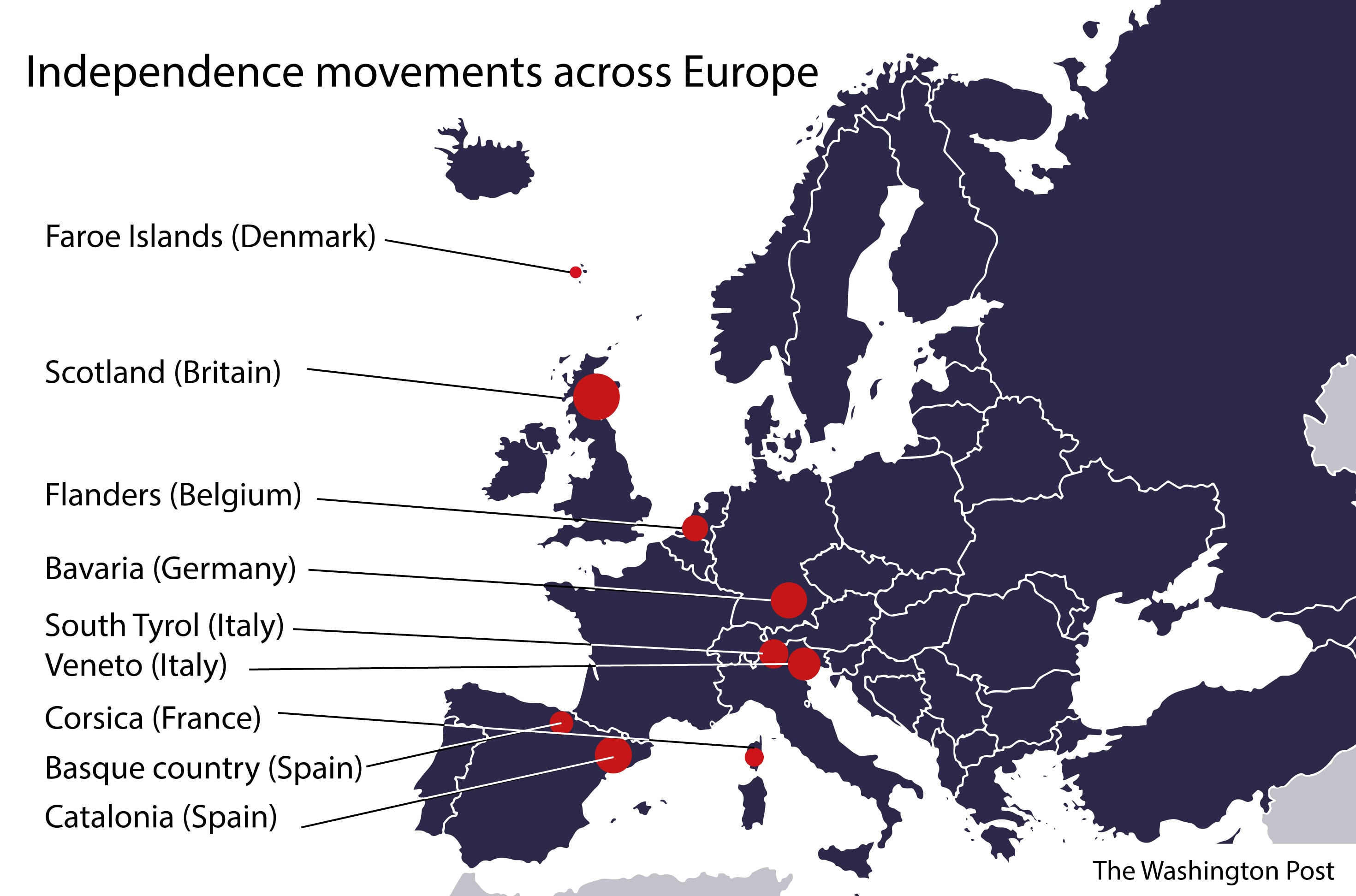
The disappointingly brief article included the usual suspects, including Scotland, Flanders, and the Basque region. However, it also introduced a few we hadn’t known about earlier, including South Tyrol (a German-speaking region in Italy that previously was part of Austria prior to WW I) and the Faroe Islands, who are itching to throw off the distant Danish yoke.

A good quick read if you like European history and geography!

Categories: Mappy Hour, Maps and Miscellany | Leave a comment

Protected: Papagayo Peninsula, Costa Rica

This content is password-protected. To view it, please enter the password below.

Categories: Costa Rica | Enter your password to view comments.

Protected: Where Better to Watch the Eclipse?

This content is password-protected. To view it, please enter the password below.

Categories: Maps and Miscellany, Miscellany | Enter your password to view comments.

Is Alexandria’s Appomattox Statue the Next to Fall?

Old Town’s iconic Appomattox statue at the intersection of Washington Street and Prince Street currently is under police protection. Someone tried scaling the statue this morning.

We talked to the cops who were on all four corners of the intersection this morning. All they knew was that someone tried climbing the statue without authorization and were there to prevent further attempts. We assume this is fallout from the jackass alt right march in Charlottesville and the resulting authorized (in Baltimore, for example) and unauthorized (in Durham) removals of Confederate statues in several states.

The ladder used by the climber was still there when we walked by (we assume that’s what it is – when we asked the cops, they said, “All I know is that it’s not ours.”)

The confederate soldier on the monument faces south, his back to the north. A stone historic marker on the southwest corner of the intersection by the Lyceum reads:

“THE CONFEDERATE STATUE

The unarmed Confederate soldier standing in the intersection of Washington and Prince Streets marks the location where units from Alexandria left to join the Confederate Army on May 24, 1861. The soldier is facing the battlefields to the South where his comrades fell during the War Between the States. The names of those Alexandrians who died in service for the Confederacy are inscribed on the base of the statue. The title of the sculpture is “Appomattox” by M. Casper Buberl.

The statue was erected in 1889 by the Robert E. Lee Camp, United Confederate Veterans.”

The north side of the statue’s base reads, “They died in the consciousness of duty faithfully performed.” The south side reads, “Erected to the memory of Confederate dead of Alexandria, Va. by their Surviving Comrades, May 24th 1889.” The east and west sides bear the names of those from Alexandria who died during the Civil War.

In the wake of other recent violent racist events south of Virginia, Alexandria’s City Council voted unanimously last year to move the statue to the Lyceum. However, a Virginia law prohibits the relocation of war memorials, rendering the vote a purely symbolic gesture.

We hope it stays, and that Alexandria’s monument to an aspect of the city’s history doesn’t become yet more collateral damage from the actions of racist morons.

Categories: Alexandria History, Maps and Miscellany, WolfeStreetProject | 4 Comments

The Smallest 5 for the Big 5-O

One of us turns 50 this year. In recognition of the milestone, we’re hitting all 5 of Europe’s “microstates” in a single road trip.

What prompted a birthday trip through Europe’s microstates? An inexplicable fixation with them since our first trip to Europe in 2002, which included a leg by train from Barcelona, Spain, to Avignon, France. When we planned the trip and looked at the train route, we noticed something to the west on the map – a country we didn’t know existed was positioned between France and Spain.

A entire freakin’ country – Andorra – lurking between France and Spain.

One of us (the one with the birthday, to be clear) has been fascinated ever since, and even tried to add a side trip to Andorra to our bike trip in Catalonia in 2009. (This was overruled in favor of Cadaques, which, we think you’ll agree, was a pretty good idea when you check out that post.)

Nonetheless, the impetus to visit the microstates persisted, and the 50th birthday milestone provided a great opportunity to finally see them.

There are some tiny regions in Europe and elsewhere, but not all can be considered microstates. For example, Gibraltar, at the southwest tip of Spain, is tiny, but it’s not independent – it’s a British Overseas Territory. Luxembourg, on the other hand, is independent, but not tiny (it covers 1000 square miles). By contrast, the microstates are truly micro – most cover less than 25 square miles and none of them exceed an area of 200 square miles.

So, other than being incredibly small, what defines a microstate?

  • Independence
  • Diplomatic recognition
  • Control of territory
  • Permanent population
  • Government

Based on these characteristics, the following sovereign countries within continental Europe qualify and will be part of the trip:

  1. The Principality of Andorra (finally!)
  2. The Principality of Liechtenstein
  3. The Principality of Monaco
  4. The Most Serene Republic of San Marino
  5. The State of Vatican City

Because none of the microstates, other than Vatican City, have rail stations (particularly Andorra and Liechtenstein – Nice and Rimini are somewhat close to Monaco and San Marino), we had to forego train travel, which otherwise is the best way to get around Europe. Instead, we’re renting a car and making this a road trip.

In our planning, we had a choice:

  1. Drive directly from one microstate to another, resulting in a couple of long days of driving, but providing a couple of rest days with no driving, or
  2. Add interim destinations between some of the microstates, so that we’re never driving more than 3 or 4 hours, but we would be driving every day

We chose Option 2:

The map above depicts the following itinerary:

  • Take a redeye to Rome
  • Day 1: Vatican City
  • Day 2: Drive to San Marino
  • Day 3: Drive to Bergamo, Italy
  • Day 4: Drive to Liechtenstein
  • Day 5: Drive to Lake Lugano, Switzerland
  • Day 6: Drive to Monaco
  • Day 7: Drive to Carcassonne, France (another place we’ve wanted to visit – last stronghold of the Cathars!)
  • Day 8: Drive to Andorra
  • Day 9: Drive to Barcelona
  • Day 10: Fly back

We’ll spend every afternoon and night in the destination town / country to check things out before heading off the next morning to the next target.

Today, we’re part of the way through the tip, in Vaduz, Liechtenstein. We’ll post highlights of the trip when we get back!

Categories: Andorra, France, Italy, Liechtenstein, Micronations!, Monaco, Road Trips, San Marino, Spain, Switzerland, Vatican City | Tags: , , , , , , , , , , , , , , , , , | 2 Comments

Blog at WordPress.com.