
The Plantation Ruins Hidden in National Airport’s Parking Garage
We’re still sorting through photos from Morocco, so in the meantime, a quick post closer to home about some nearby history hidden in plain sight.
Within the parking garage at Reagan National Airport just north of Old Town there lies the ruins of a colonial-era plantation connected to George Washington. The ruins are completely enveloped by the parking garage structure, but you can tell where the plantation ruins are as you’re driving by on the parkway by the looking for the trees that appear to grow out of the parking garage roof.
After seeing this for years, and as consummate history dorks, we checked it out.
Abingdon Plantation ruins’ green space within the garage from in a satellite view on Google Maps:

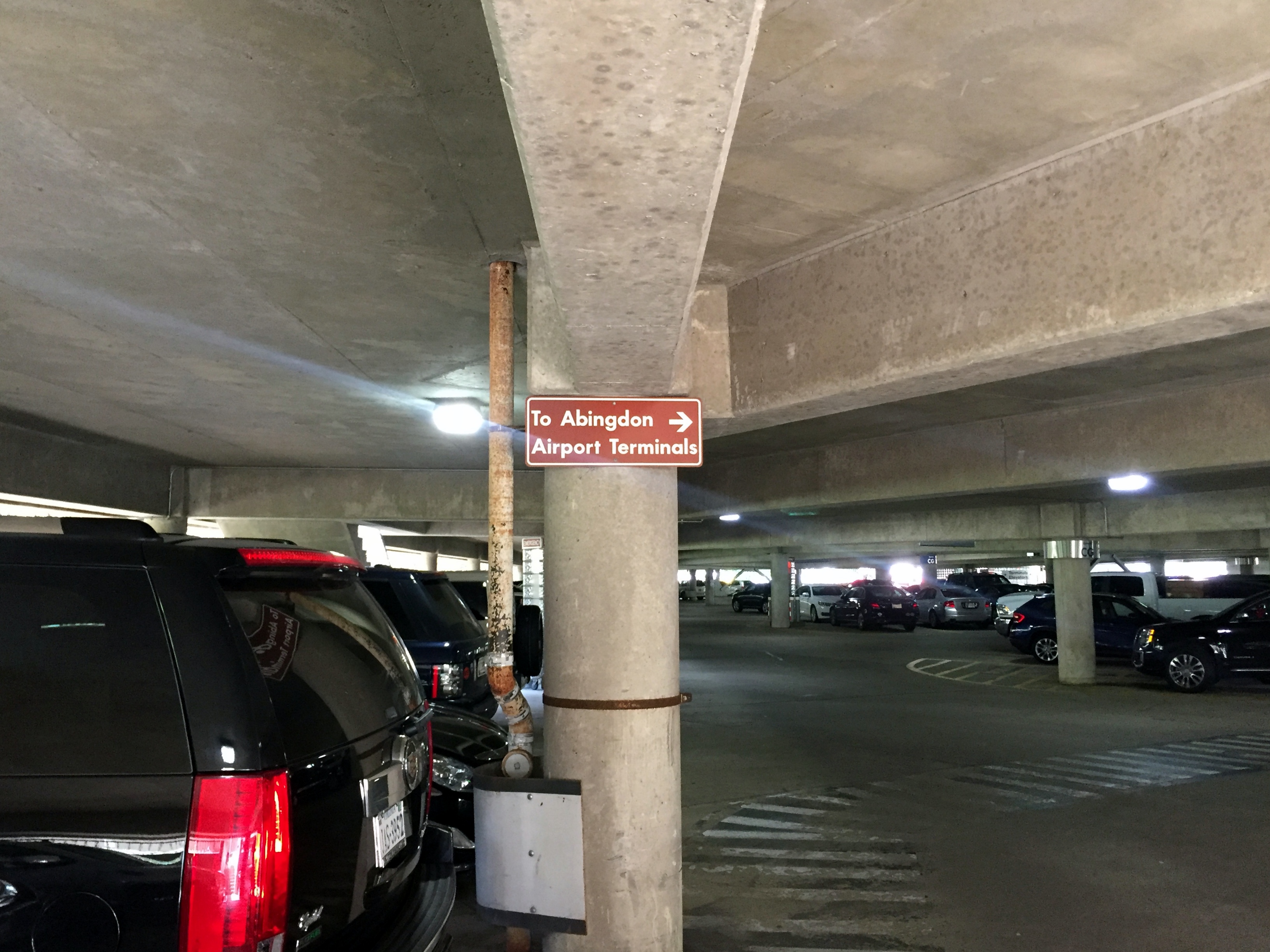
There are a few signs in the Reagan National Airport parking garage leading to the ruins of Abingdon plantation. However, considering that most people parking there need to catch a flight and don’t have time to wander around to see the landmark, we’re no sure how often the spot actually gets visitors.
However, since National Airport is a short bike ride away for us, we rode there on the way to a longer ride up the Capital Crescent Trail to Bethesda for lunch. There’s actually biking infrastructure involving a few paths, a tunnel, and the parking garage that connects National Airport to the Mt. Vernon bike trail next to the parkway. (We have a friend around the corner who used to tow one of his kids in a Burley and bike from Old Town to the National Airport terminal for lunch at Legal Seafoods, which is located outside security. Go figure.)

The first helpful sign in the ground level of the garage near the bike entrance:
Directions to the plantation ruins in the breezeway between the terminal and parking garage:

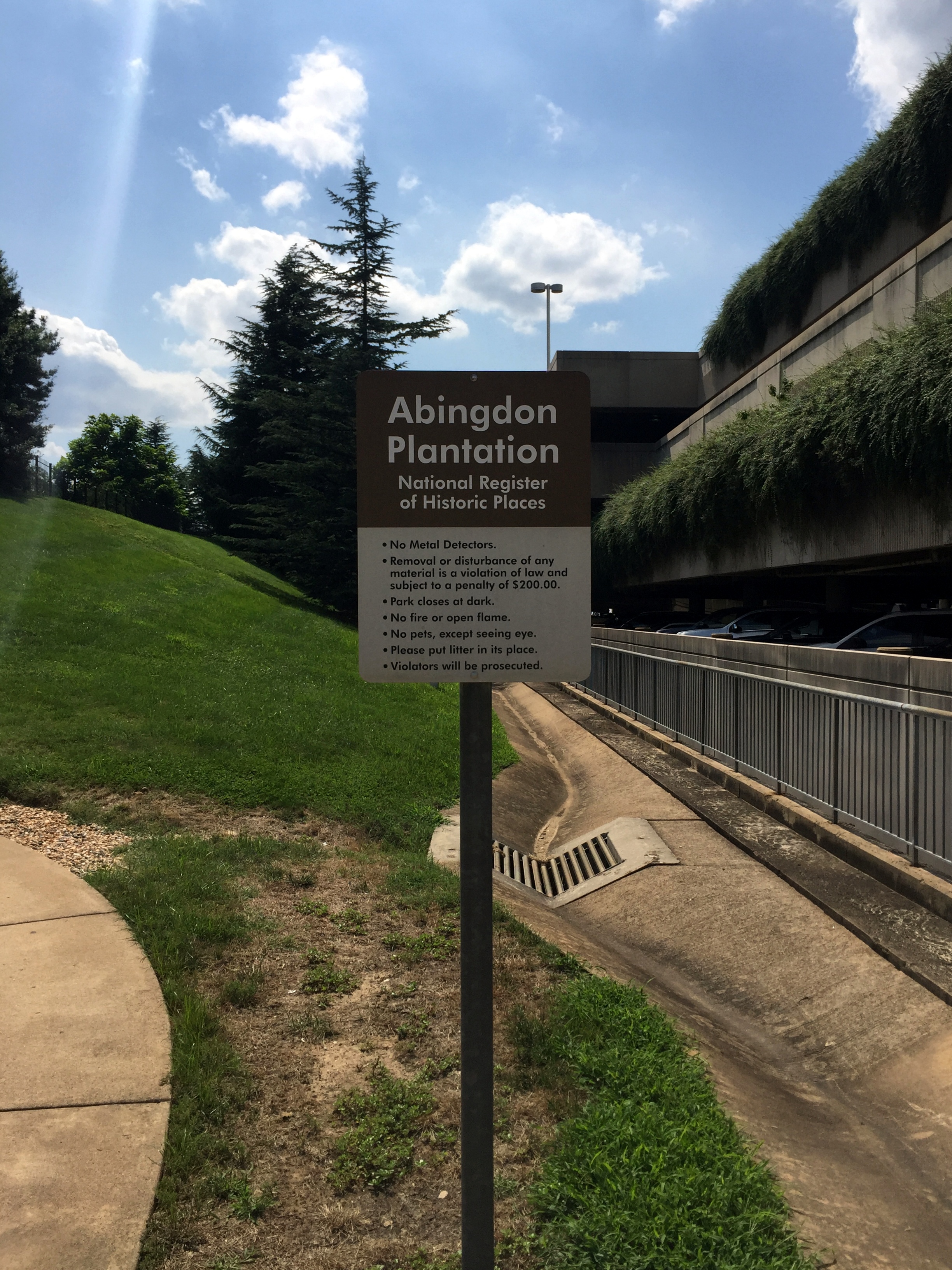
Entrance sign to the plantation ruins; Parking Garage B is to the right:
The ruins are just up a path:

Remains of the main house with the airport terminal in the background:

Context of the ruins within the airport from signage at the site:

Remains of the kitchen building with Parking Garage C behind it:

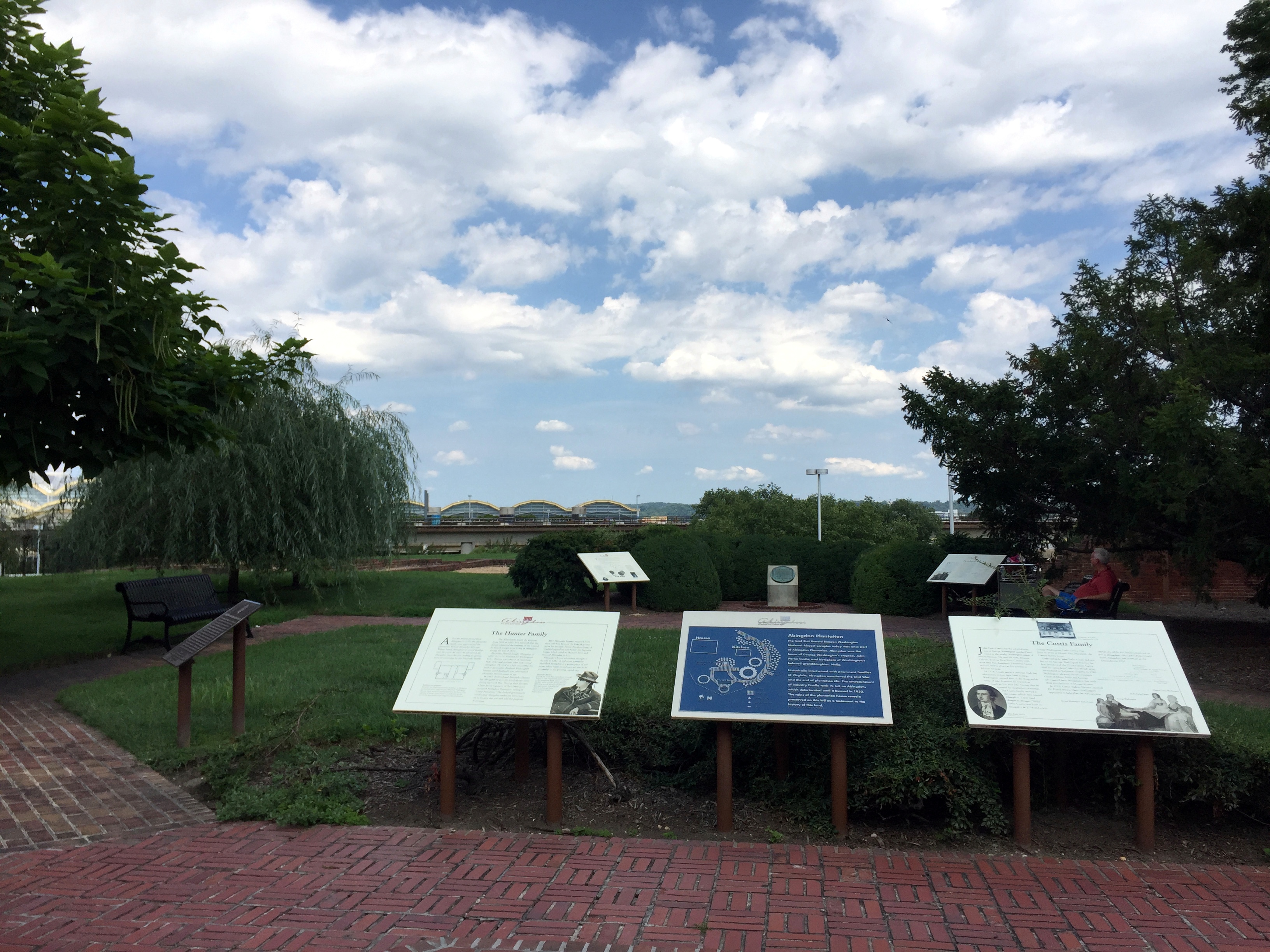
Lots o’ signage at the top of the mound, overlooking both the ruins and the terminal:
Layout of the ruins:

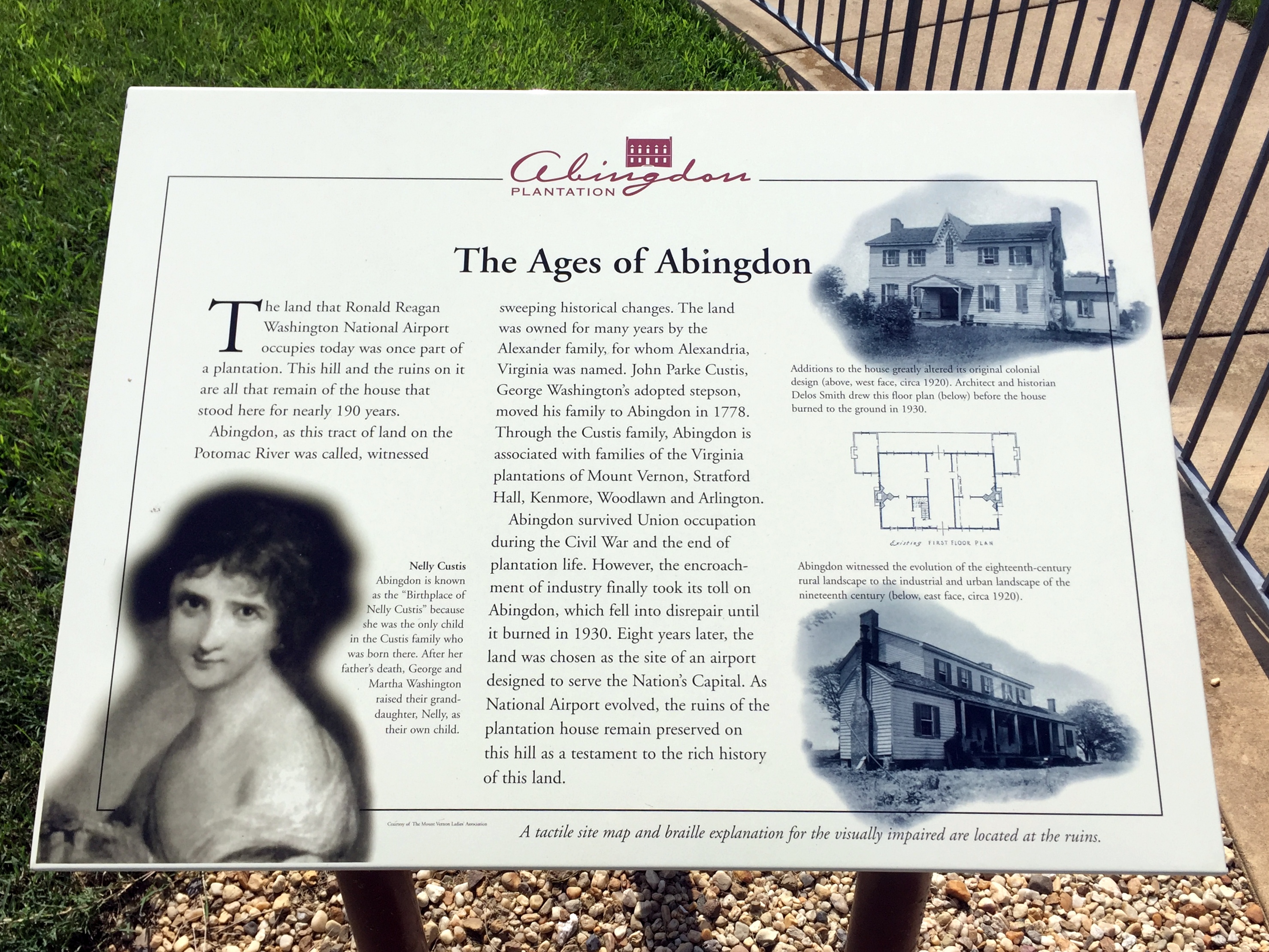
Pretty well done historical markers providing the history of the place:
Instead of trying to read the signs, here’s an easier approach – this article on Atlas Obscura (which is an absolutely phenomenal site, btw):
“Abingdon was built in 1695 by the Alexander family, whose name was later conveyed to the nearby port town that we know today as Alexandria. Years later, George Washington’s adopted stepson, John, purchased the house so that he could live closer to the Washingtons’ home at Mount Vernon.
The property later reverted to the Alexander descendants, named Hunter, up until the Civil War when the confederate sympathizers fled south. Like the nearby Custis Lee Mansion (today, Arlington National Cemetery), Union troops took the property over and made camp on the lawns. After the war, the Hunters returned and successfully sued the government for rights to Abingdon. The lawyer, incidentally, was James Garfield, the future president of the United States.”


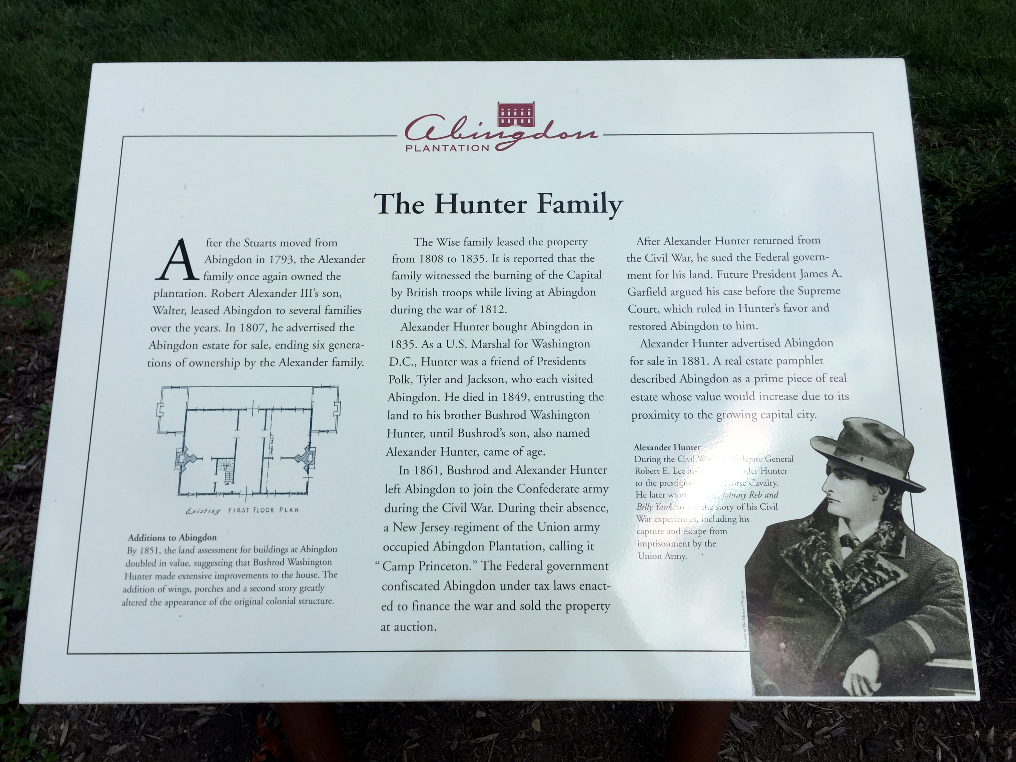

“The mansion itself burned down under suspicious circumstances in 1930. It was possibly an act of arson—the RF&P Railroad wanted to build on the site, and had previously “invited employees to strip the house” in order to “save demolition costs,” according to the Washington Post.
The ruins of Abingdon then sat abandoned for 11 years until Washington National Airport was built on landfill just north of the site. The airport’s continued expansion over the years again threatened Abingdon. In 1990, the Washington Metropolitan Airports Authority proposed bulldozing the fenced-off site to make way for a new parking garage. A vigorous preservation campaign played out in the city’s newspapers, and the ruins of Abingdon reopened in 1998 as a little park.”
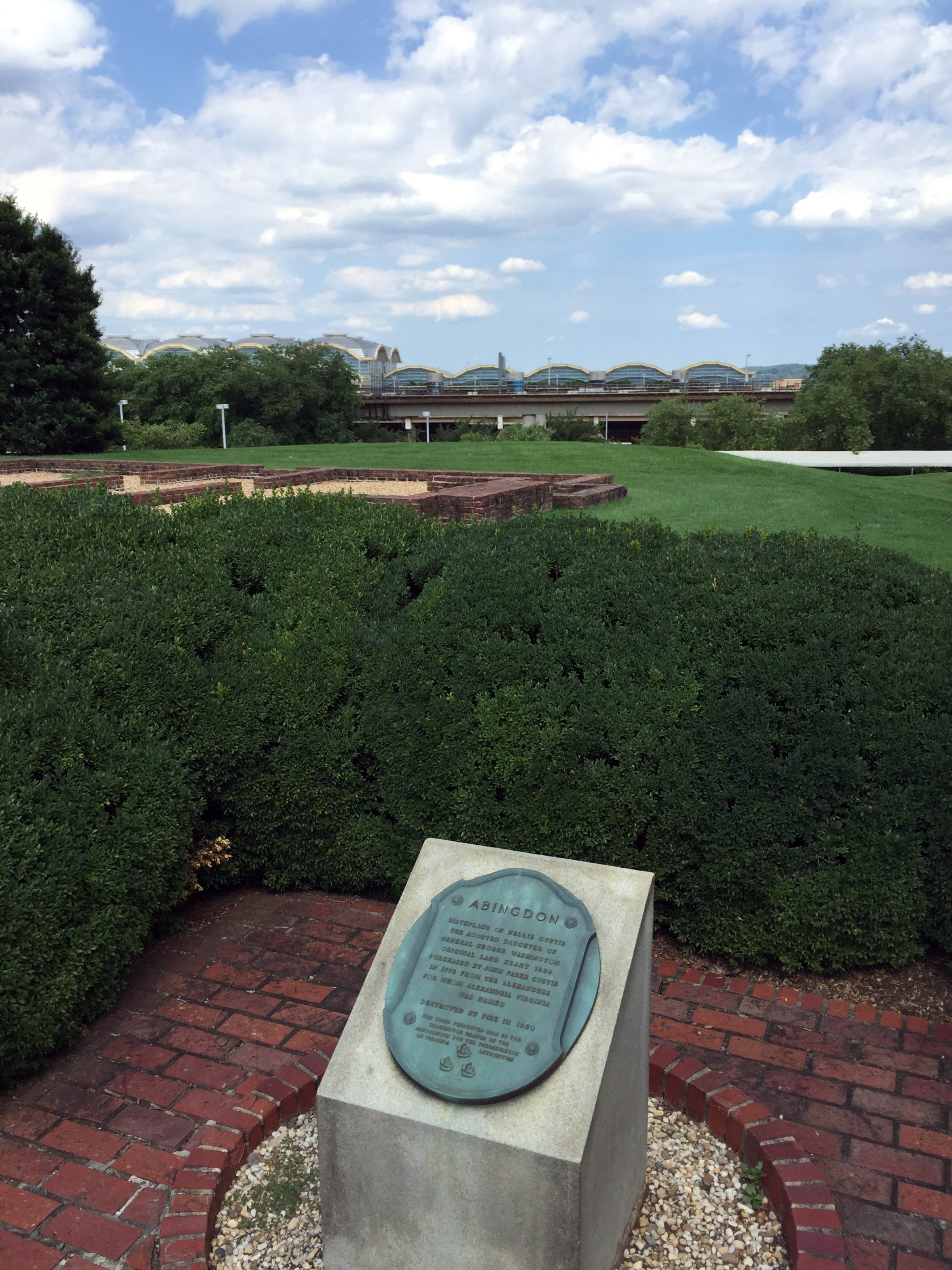
The George Washington connection: Abingdon is the birthplace of Eleanor “Nelly” Parke Custis Lewis, Martha Washington’s granddaughter:

Mount Vernon’s Hidden Entrance
Mount Vernon is located just south of us, right down the aptly named George Washington Parkway. Visitors to Mount Vernon pass through the main entrance, beyond which – and out of sight – lie the mansion, out buildings, and gardens.

There’s a great 30-mile-loop bike ride from Old Town we frequently use that passes by Mount Vernon as the route continues to the turnaround point in Yacht Haven, so we encounter the estate’s entrance several times a month.
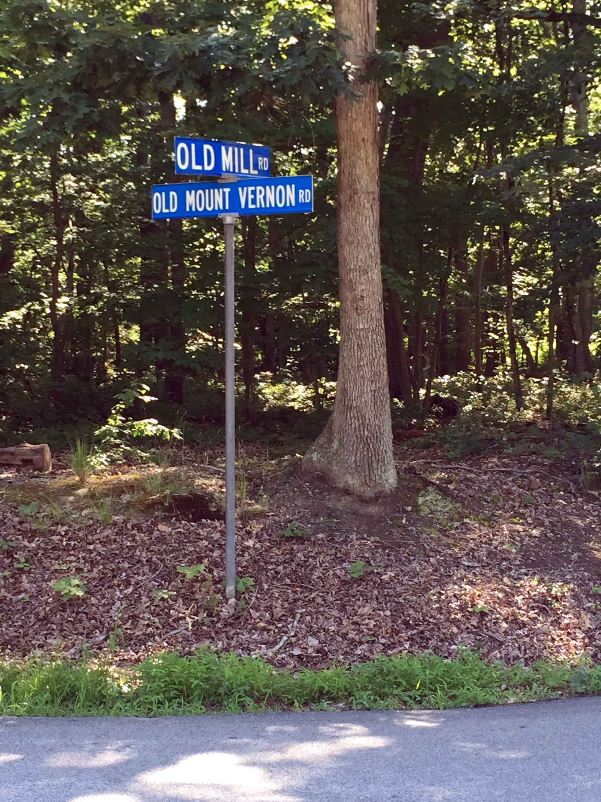
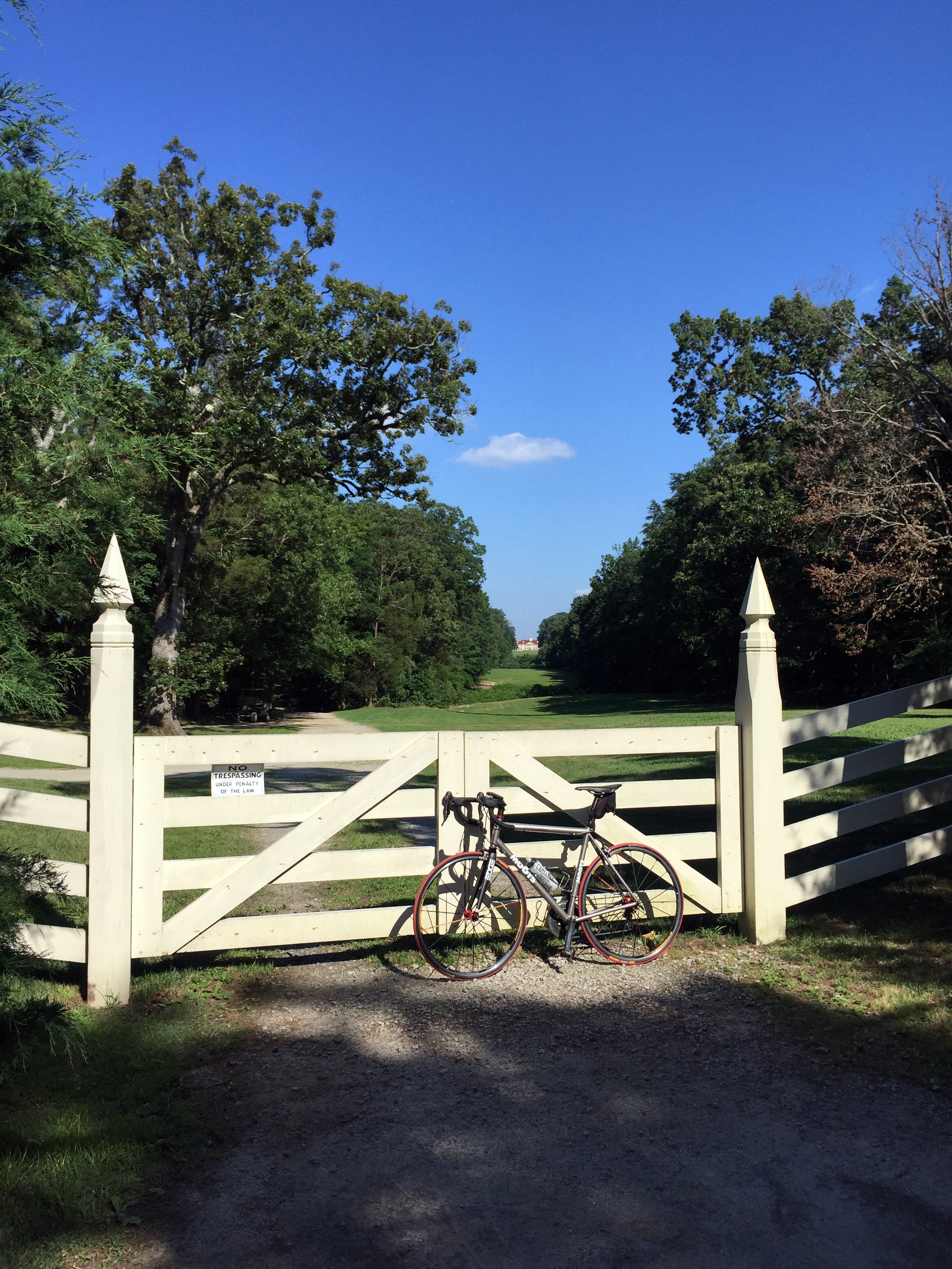
However, the ride also passes by a different portal into the estate that tourists have no idea even exists: the overlooked West Gate.
Mount Vernon’s West Gate is located at the opposite end of the estate and off the parkway itself. The Google Earth image below shows the main entrance to Mount Vernon on the right (at the base of the roundabout) and the West Gate indicated by the red dot on the left.

The gate lies along an unassuming stretch of the appropriately monikered Old Mount Vernon Road at its intersection with Old Mill Road:
The trajectory of Old Mill Road would continue straight through to the mansion, if not for the gate:

Beyond which lies Mount Vernon itself,
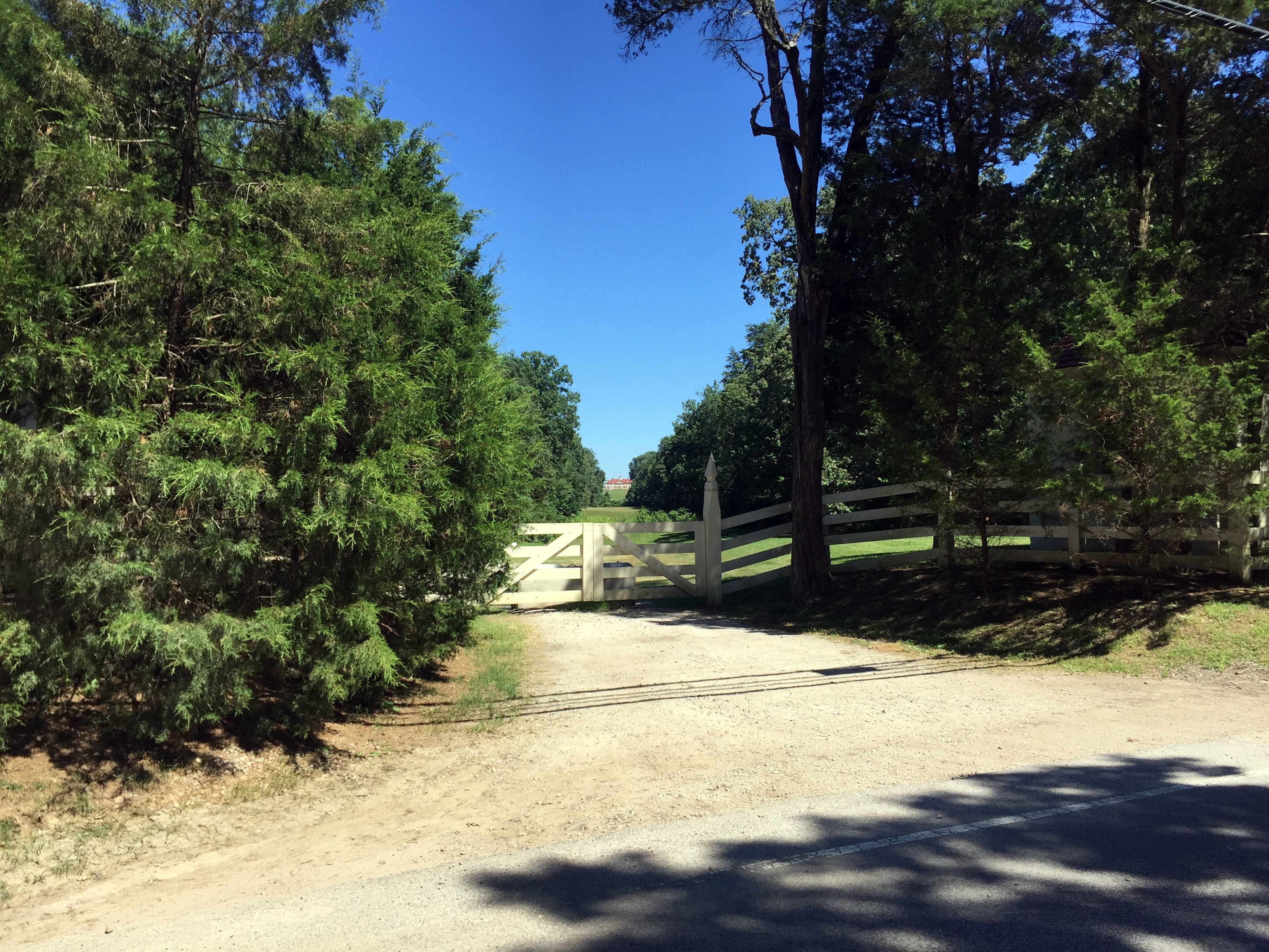
From the mountvernon.org site regarding traveling to Mount Vernon when George and Martha still occupied the estate: “Since the wharf on the Potomac River was reserved almost exclusively for deliveries, most of George Washington’s visitors arrived overland, on roads and paths that meandered past the fields and pastures surrounding the Mansion Farm House. Washington places a premium on first impressions. Visitors first sighted the Mansion from what is now known as the west gate. From there, they were afforded a “visto”, or view, of the west face of the Mansion, in front of which were cleared land and rolling hills for about seven-tenths of a mile.”
This 18th-century “visto” still exists, under the radar, and unknown to the tourists piling out of buses and filing into the main entrance:

Brief information on the West Gate right inside the barrier:


Definitely worth a look the next time you’re riding (or driving) near Mount Vernon:
The Abandoned Rodman Guns of Fort Foote
So, we were supposed to be publishing posts from our Edinburgh trip this weekend (as well as a bunch of other backlogged posts), but it’s too much work right now.
However, after a ride today over the Woodrow Wilson Bridge into Prince Georges County, we thought this may be interesting to share instead. All of the quoted information below is from this helpful National Park Service site.
Fort Foote was one of 68 ring forts constructed during the Civil War to protect the capital city from Confederate attack. It’s still around, but is well and truly hidden. Seriously. We grew up in the area, are well aware of Fort Hunt on our side of the Potomac and the massive Fort Washington on the opposite shore, and had never heard of Fort Foote. It took the 2008 opening of the Woodrow Wilson Bridge replacement – with outstanding pedestrian and bike infrastructure to reach Prince Georges County – to make us aware of its existence. Even with this revelation, it’s still jarring to wander through the overgrown site, turn a corner, and stumble upon the massive abandoned Rodman guns.
Some background on Fort Foote from the Park Service:
“In 1862 the battle between the Monitor and Merrimac, at Hampton Roads, created panic in Washington. As the war progressed, many European countries seemed eager to join the fight on the side of the Confederacy. Fort Washington, on the Potomac River 16 miles below Washington was considered too far away to be adequately supported. Therefore the protection of the city from naval attack became a major concern and army engineers began building earthworks to resist naval bombardment.”
“In the words of General Barnard they were “in many respects, model works. Fort Foote was constructed for the purpose of defending, in connection with Battery Rogers, the water approach to the city.”
Battery Rodgers, as it happens, is just a few blocks away from us in Old Town – there’s a historical marker on the 800 block of South Lee Street, just a little west of where the battery stood during the Civil War.
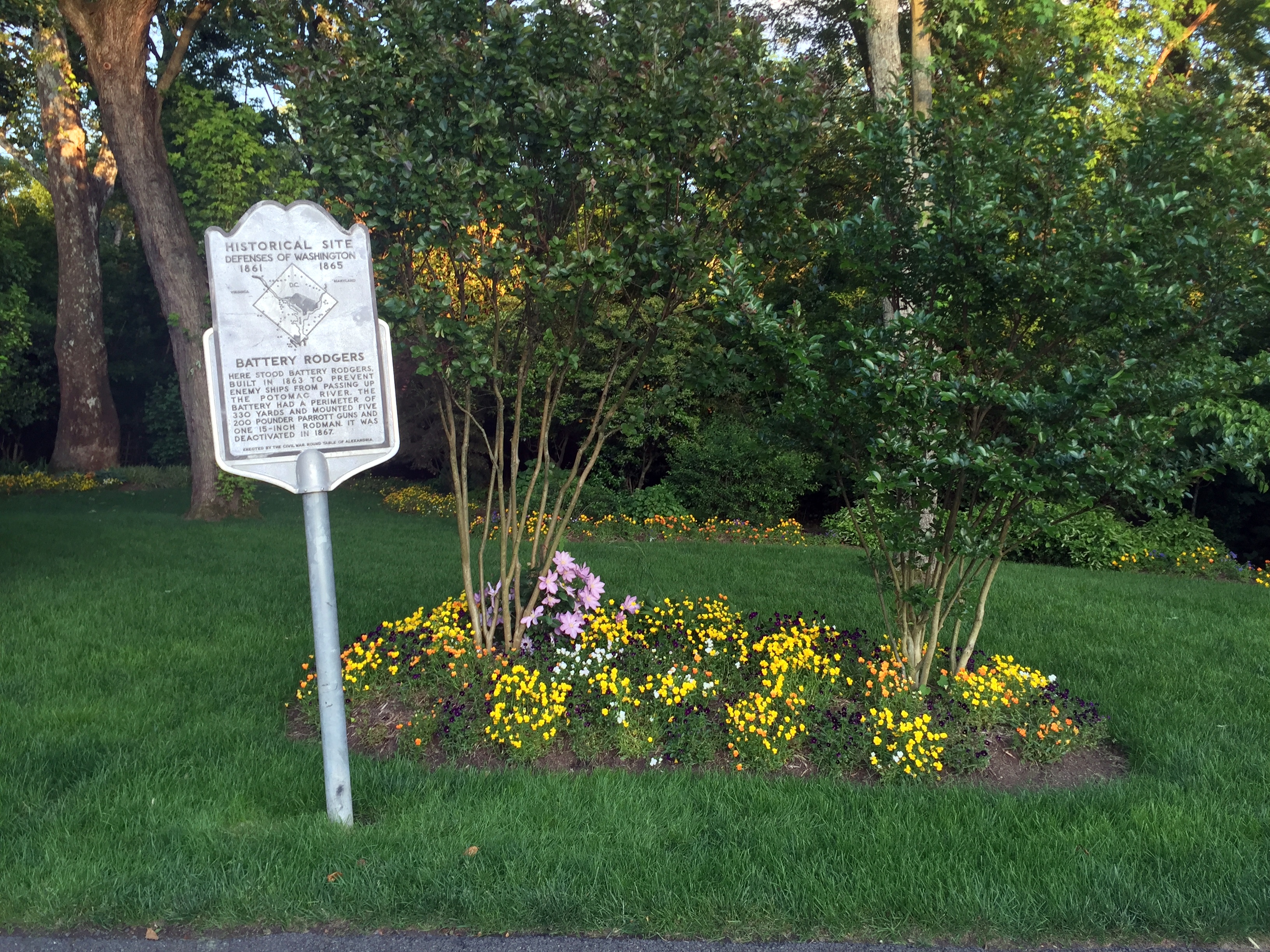

“Fort Foote was situated six miles below Washington,on a commanding bluff of the Maryland shore, elevated 100 feet above the river. The fort was essentially completed in the fall of 1863, and was designed as a water battery of eight 200-pounder Parrott rifles and two 15-inch guns.”
Location of Fort Foote (and Battery Rodgers):

The Saturday in May 2008 that the new bridge and bike lane opened, one of us headed across to explore, with Fort Washington as the destination for the ride. On the way, right on the curve of Fort Foote Road, was an unassuming sign in a field by an empty gravel parking lot.

There only signage in the park is a hundred yards into the woods, where there’s barely a trail to follow:

Even from this location, there was no fort or guns to be seen. Only a long berm, overgrown with bushes and saplings. This turned out to be the remains of one of the earthworks.
Beyond, lay one of the guns:

Some background on Fort Foote’s firepower during the Civil War from the Park Service site: “The first 15-inch gun arrived in the fall of 1863 and by April 1865 the fort boasted of two 15-inch Rodman Cannons, four 200 pounder Parrott Rifles and six 30 pounder Parrott Rifles. The work was declared complete on June 6, 1865. A large crowd of civilian and military observers gathered to watch the guns fire on February 27 and again on April 1, 1864. The 8-inch Parrott Rifles weighed over 8 tons and used 16 pounds of powder to fire its 200-pound projectile 2,000 yards down the river. But the fort’s main attraction was the 15-inch [Rodmans]. They weighed in at 25 tons and required 300 to 400 soldiers to move them up the bluff from the river. Forty pounds of powder could send a 440-pound round-shot over 5,000 yards.”
It’s difficult to convey how truly huge these mothers are without some perspective, even from a shot this close:
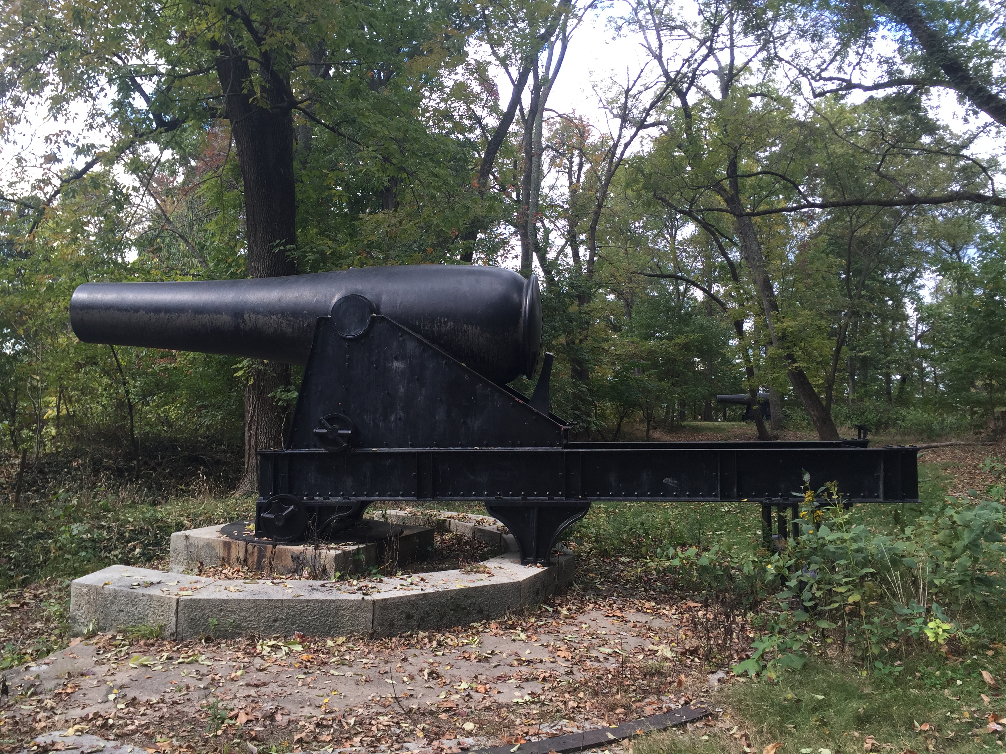
So, some perspective:

The guns are massive, and they’re basically just abandoned in the woods. “During the Civil War the 15-inch guns cost the government $9,000 each but they could do major damage to a wood sailing ship-of-war. At close range, even the iron clads were not safe from the massive weapons.”
“During our Civil War most European navies armed their vessels with 9-inch rifled guns. Other technologies such as the screw propeller, steam engine, rotating gun turret and iron-sided ships with watertight compartments were making our seacoast defenses obsolete. Our government could not afford an arms races so it was decided to wait and see how the gun versus ship race progressed before investing in changes. In 1870, the army started an extensive program to modify existing defenses. Inexpensive earthwork batteries were armed with existing smoothbore guns, primarily the 15-inch Rodman. A few guns were mounted but funds were withdrawn in 1875. The Chief of Engineers stated in his 1877 annual report, “Our largest guns, of which we have any number, is a 15-inch smooth-bore, and weighs over 25 ton. We have about 325 of them for our entire coast of 12,600 miles.”
The 15-inch gun was finally tested at Sandy Hook, NJ in 1883. It was found that 130 pounds of black-powder created 25,000 pounds of pressure in the chamber and at 20 degrees elevation the gun could send a 440-pound shell over 3 1/2 miles. At 1,000 yards the round-ball projectile could pierce 10 inches of iron. No warship, regardless of how well armored, could afford to trade shots with a 15-inch Rodman at close range.”
I’ve brought riding partners to the site when they join me for the ride east from Alexandria into PG County, and some have found more creative ways to provide the size context:

If you have 15 minutes to blow after a visit to National Harbor, Fort Foote is worth checking out. Unassuming, overgrown, and with two big ass Rodman guns sitting in a sylvan setting as incongruous reminders of the site’s power for a few years in the 1860s. The now-homely site even hosted some notables during the war:
“The first unit to garrison Fort Foote was four companies of the 9th New York Heavy Artillery that arrived on August 12, 1863. The post was commanded by lieutenant Colonel William H. Seward, Jr., the son of the Secretary of State. The secretary visited the post often while his son was in command and President Lincoln visited the fort on August 20, 1863 with the Secretary of War and number of high-ranking army officers.”

Edinburgh: New Town & Around Town
Edinburghs’ New Town lies below Edinburgh Castle, Old Town, and the Royal Mile. It’s a planned city, laid out and constructed between the mid 1700s and the mid 1800s and is crammed full of classic, symmetrical, visually tedious Georgian architecture.
Perhaps the most prominent (and definitely not Georgian) landmarks in New Town is the Sir Walter Raleigh Monument, the second-largest monument to an author in the world. This Victorian Gothic spire is crammed full of literary (Sir Walter’s stuff) and historical (Scottish) figures. There’s a total 93 people propped all of the surfaces of the monument. Plus two dogs and a pig.

The local birds just hanging out with Sir Walter after shopping at Jenners across the street.

We popped in and out of New Town each of the three days we were in Edinburgh, and the weather was as variable as our last two posts. Edinburghers (?) hanging out in the sun in the plain below Old Town our first day . . .

And this scene from the same location the next day:

The grassy depression, btw, is what’s left of Nor Loch, which was drained in the 19th century and filled in.

Nor Loch in a painting by John Slezer in 1639
Sunny New Town!

Crappy New Town!

A final, moody shot of the castle from a graveyard on the outskirts of New Town before we move on:

Wait – this too! A cool, 3-D plaque over the grave of William Bonnar on the wall above. We only took the picture because we thought the color, texture, and relief contrast looked interesting for a picture, but it turns out that Willy was not only a noted Edinburgh painter, but also is credited with completing the Sir Walter Scott memorial discussed above. How serendipitous!

Scenes around New Town, including the Melville Monument (not to Herman, but to the first freakin’ Viscount of Melville, which we don’t believe rates this level of recognition).


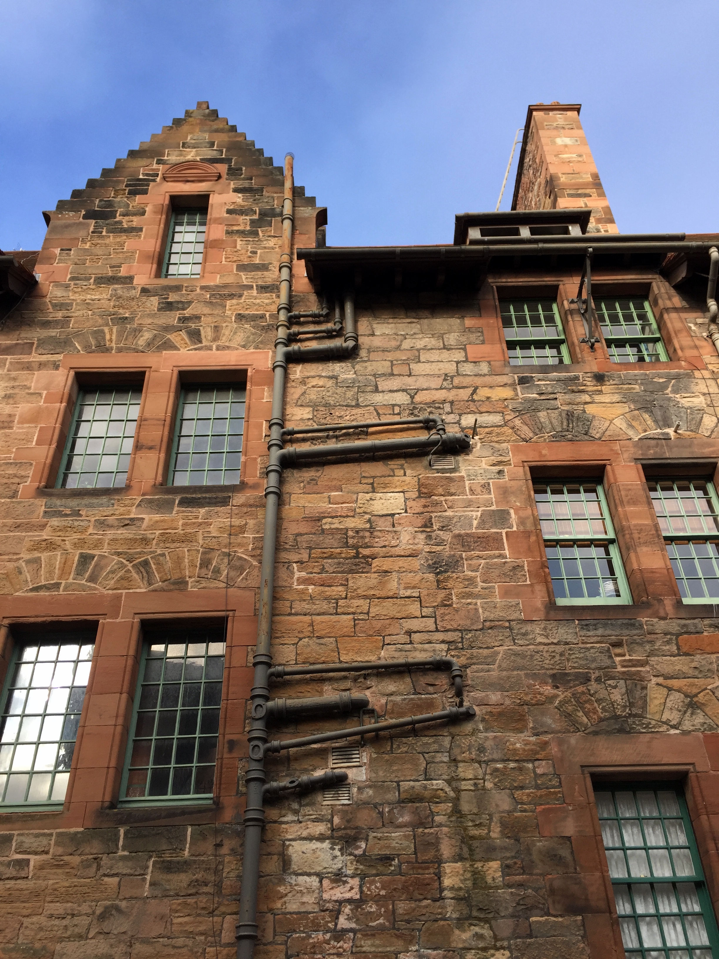
And now for something completely different: beautiful, tranquil, and bucolic Dean Village, a 19th-century mill town just on the outskirts of New Town Edinburgh.

The town’s mills were overtaken by larger, industrial-scale capabilities elsewhere, and Dean Village lay in decrepitude until the 1970s, when residents recognized the benefits of renovating mill workers’ houses to live here with a walking-distance commute into Edinburgh. Now it’s rather quaint.


Here’s a great way to overcome pluming challenges during renovation – just stick the outgoing pipes outside the house. Problem solved!

One of us reluctantly agrees to humor the other and sit on a bench that the other thought was compelling and Escheresque. It wasn’t.

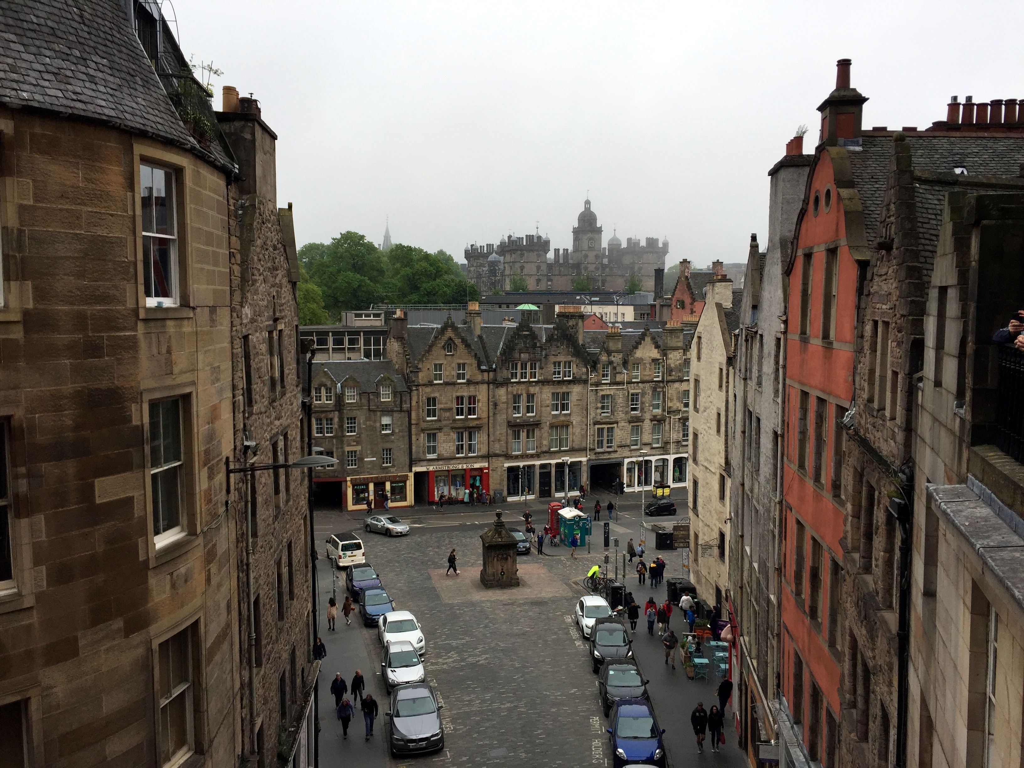
Victoria Street, leading down from the Royal Mile to Cowgate, Grassmarket, and points beyond.

We had midday beers at a bar on the terrace above . . .
and noshed on some roasted pork action along the street at this place:


Later that evening on the same street, we tucked in to yet another variation on the haggis theme – this time haggis as the filling in savory fried doughnuts:

We would say “‘sokay” – not the best we experienced, but enjoyable nonetheless.
Moving on . . .
Cowgate’s a for real place in Edinburgh – it’s the portal into the city through which the local farmers (ranchers?) would bring their bovines.
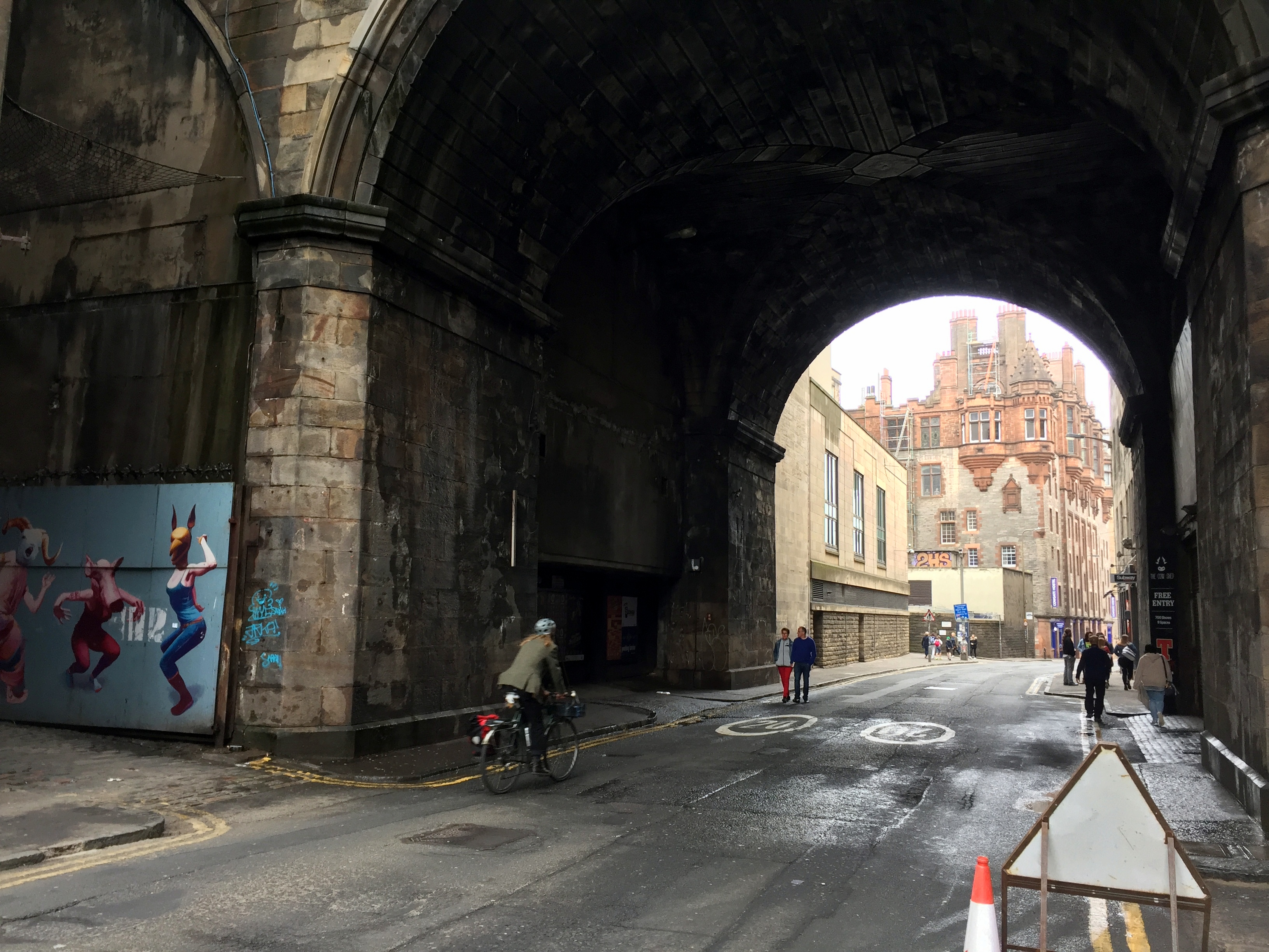
In the category of “you never know what you’ll find unless you look,” there’s a shrine in the Cowgate underpass to James Connolly, an Irish revolutionary who was born at 107 Cowgate (an area then known as Little Ireland).
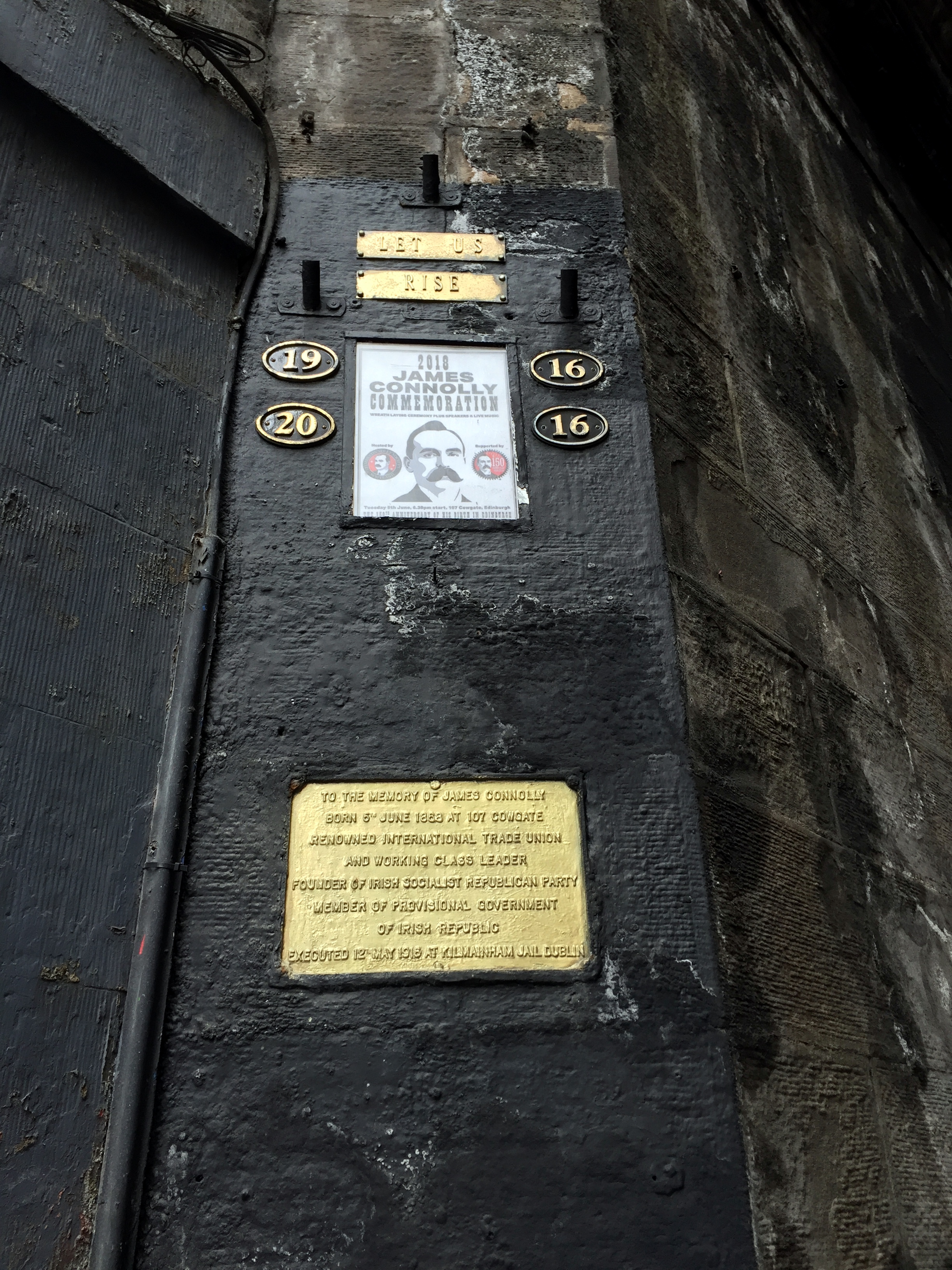
During the 1916 Easter Rising in Dublin, “Connolly was Commandant of the Dublin Brigade. As the Dublin Brigade had the most substantial role in the rising, he was de facto commander-in-chief. Connolly’s leadership in the Easter rising was considered formidable. Michael Collins [leader of the Provisional Irish Free State in the early 1920s (and cousin of one of our paternal grandmothers, btw)] said of Connolly that he ‘would have followed him through hell.'”
As a complete non sequitur to that somber note, just the next block up there’s this appropriate treatment of Cowsgate on the corner of a building:

Some serious paella offered one morning at the Grassmarket um, market:

View of the castle from Grassmarket:

Greyfriars Kirkyard, which we passed through on the way from Old Town to the Scotland National Museum. We ignored the Bobby statue out front.

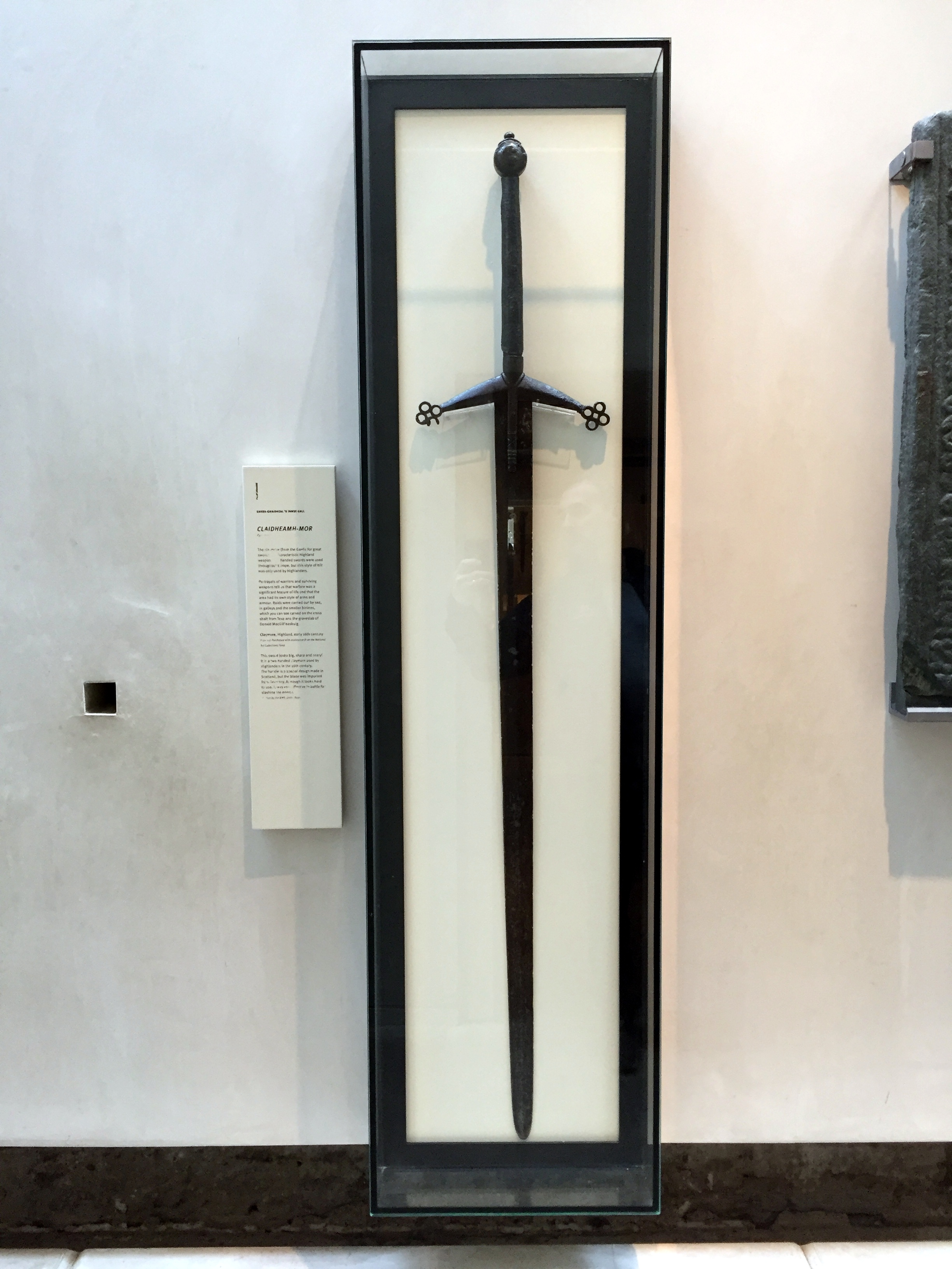
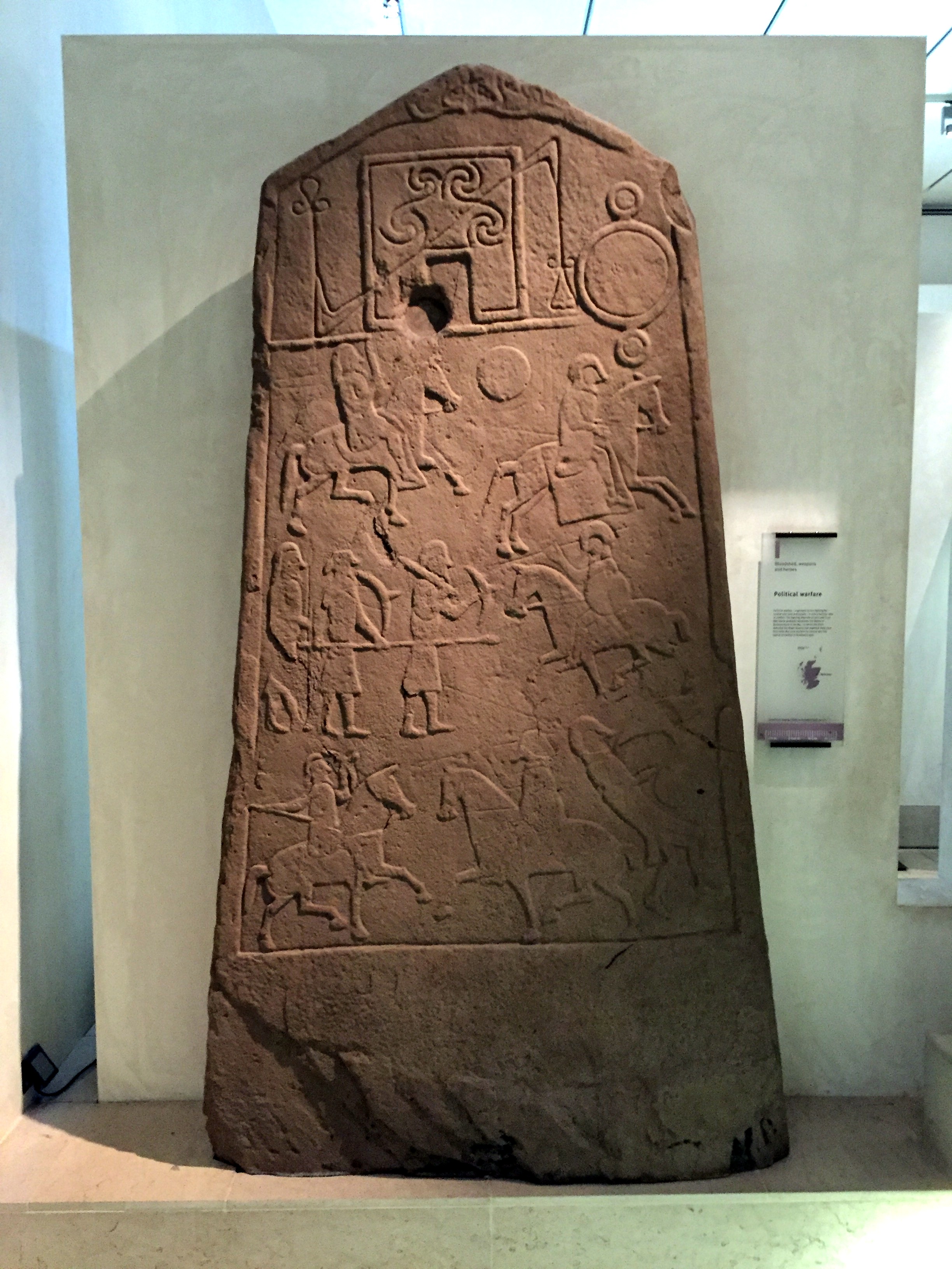
A few cool items from the museum, including a big-ass claymore (a term anglicized from the Scots-Gaelic claidheamh-mór “great sword”),
a Pictish stone generally considered to depict the Battle of Dun Nechtain between the Picts and Northumbrians in 685,
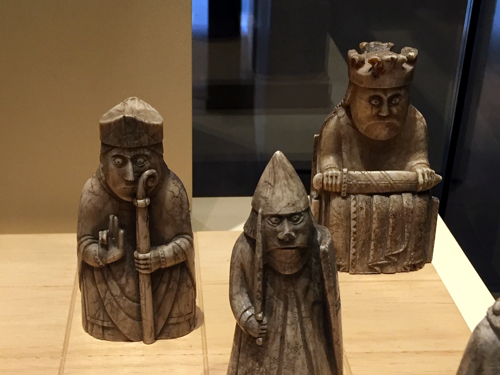
and the 12th- to 13th-century Lewis chess pieces, which originated in Trondheim Norway and were found in a hoard in Scotland.

The Norse Vikings either had some serious thyroid conditions or they’re simply surprised to see us.
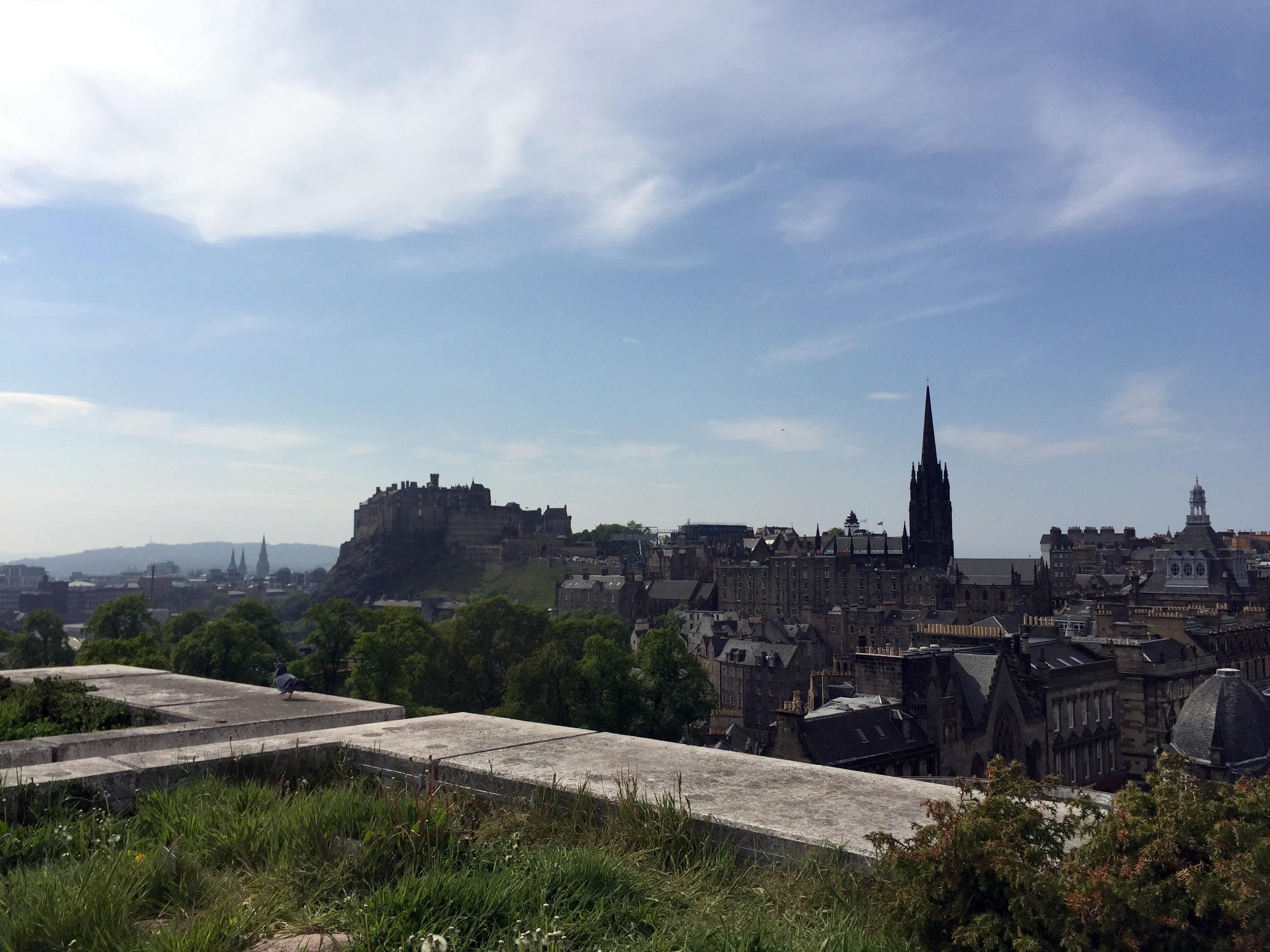
Bonus while at the museum – great views into Old Town from the rooftop:
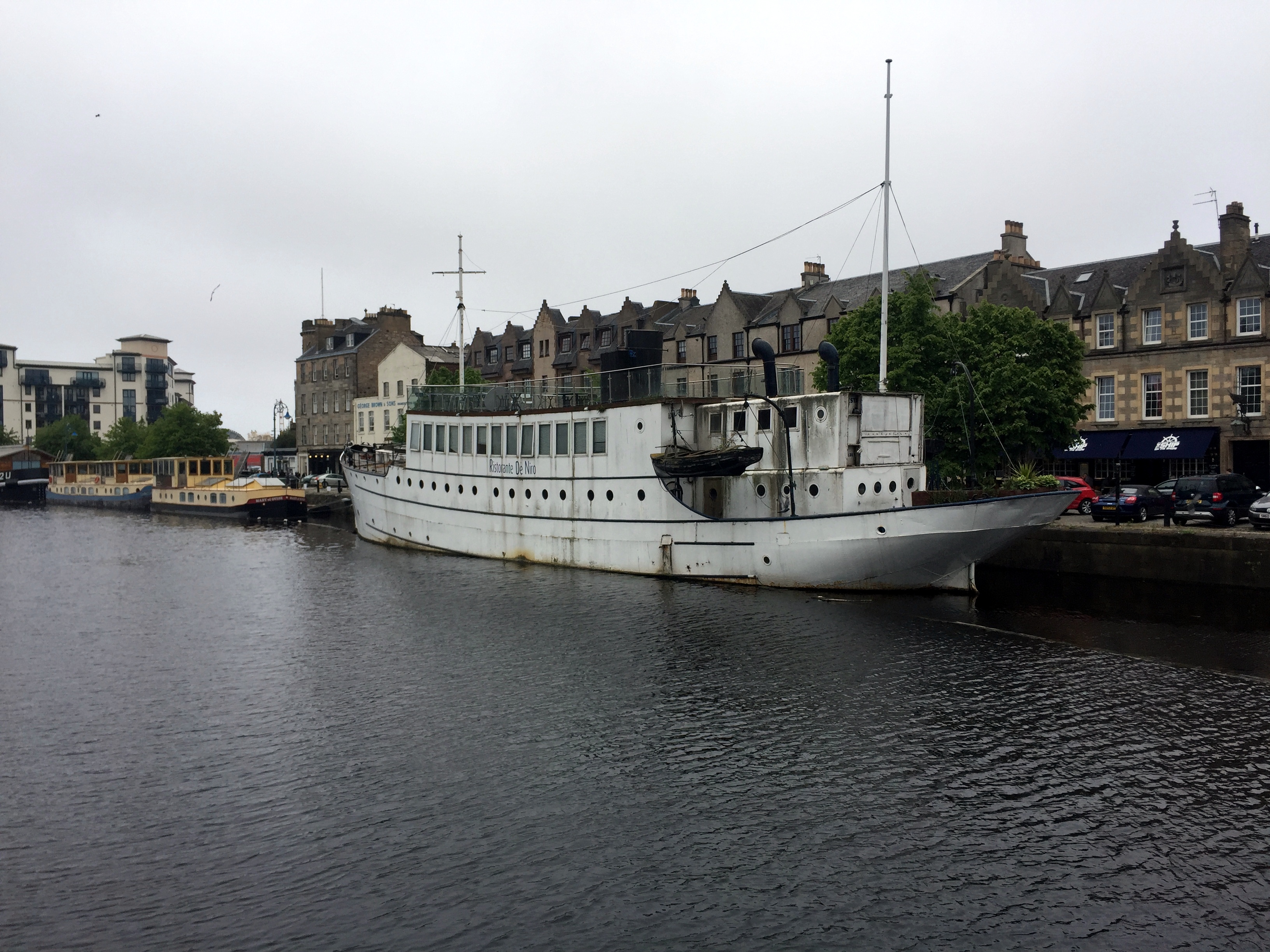
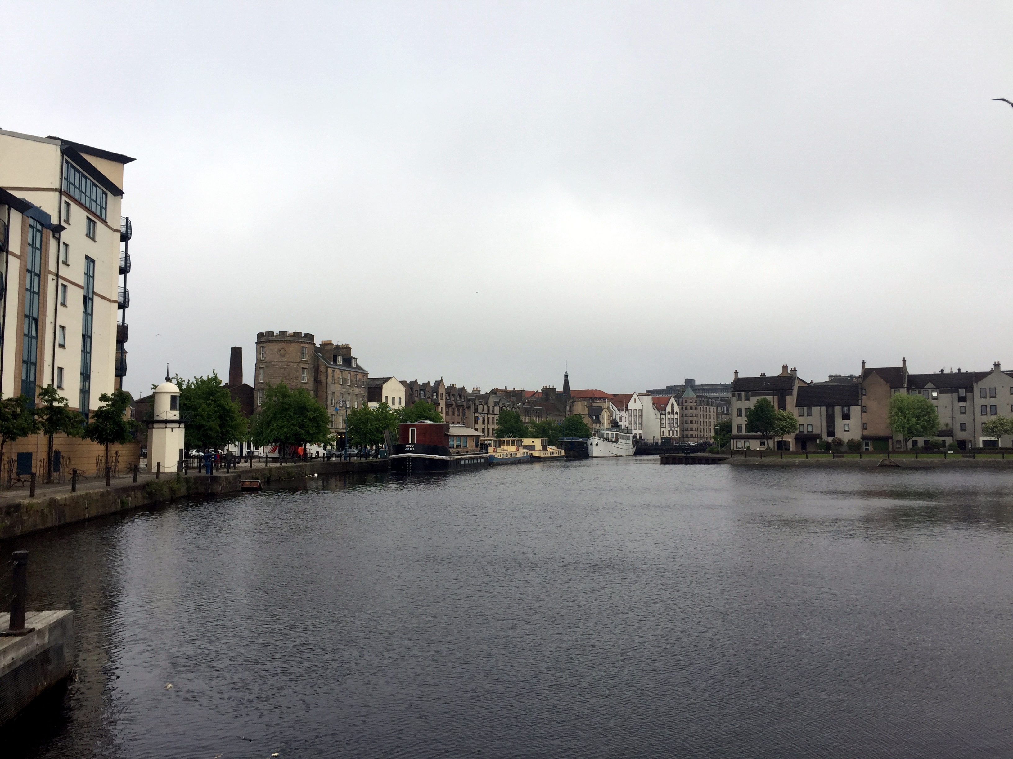
We struck out from the center of Edinburgh one evening to have dinner on the water in Leith. The couple of bars we popped in on were great, the restaurant was okay, but the setting not so much.
Scottish Merchant Navy Memorial on the waterfront in Leith:

(Our Navy – Merchant Marine Memorial on the Parkway across the river from DC is way better, for what it’s worth:)

Leith waterfront:
Dinner at a gastropub in Leith – great Scotch egg and our fourth haggis of the trip!


Thus concludes our posts on Edinburgh – perfect location to visit for a long weekend, and we’re now drinking whiskey out of the cool and ubiquitous glasses we experienced on our first night in the city (and continued to utilize throughout our stay . . .).

Edinburgh: Lower Mile
Edinburgh Castle dominates the upper end of the Royal Mile; Holyrood Palace, the royal family’s Edinburgh residence, anchors the lower end. More importantly, though, that end of the Royal Mile is the site of Arthur’s Seat, which we saw from the castle, and we wanted to start our morning with a hike up that hill and take in some great views of Edinburgh.
As it happened, the Edinburgh Marathon was held the same morning, and the stragglers were still on the Mile while we headed to our hill:

Later that evening, we hung out with one of the race participants in a pub on this end of the mile:

Also along the Royal Mile in this direction were a few odds and ends worth noticing. First – and we should have included this in our Upper Mile post – the Closes of Edinburgh:

Edinburgh’s multistory tenement buildings lining the Royal Mile effectively form a wall that’s not punctuated by very many roads. You’ll walk blocks without a road piercing the buildings on either side, so it feels a little like a canyon. What it IS punctuated with are dozens of narrow, cramped passages that lead from the street to behind the buildings. With that, here’s some more details from this Amusing Planet article:
“The Old Town of Edinburgh, Scotland, consisted originally of the main street, now known as the Royal Mile, and a large number of small alleyways that led off it to the north and south. Some of these lead to open courtyards and are therefore called ‘courts.’ Others are open thoroughfare wide enough for a horse and cart, and are called ‘wynds,’ a reference to the way they wind along. But most of these alleyways are called “closes,’ because they lead to private property and are hence gated and closed to the public. Back in medieval times, Royal Mile was lined with individual plots of land with paths to gain access to the land behind. As each plot became built up over time, these paths or closes developed into narrow lanes connecting courtyards and streets behind the Royal Mile. Tall buildings on both sides gave many closes a canyon-like appearance and atmosphere. Most closes slope steeply down from the Royal Mile. For anyone walking down the long flights of stairs, it creates the impression of walking into the underground.”
There’s a very cool detailed map of the Closes here which is worth a look to get an idea of what a hive of holes the closes form between buildings.
Back on our way down the road to Arthur’s Seat. Here’s another little item encountered on the way, of interest to one of us with some experience in water resources:

And, another cool fountain head to add to our collection (the best of which, from Arles, used to serve as our avatar on WolfeStreetTravel and continues to serve as such for our TripAdvisor profile):

A block further, there’s a plaque to Golfers Land from the 17th century and a crest featuring a fist grasping a golf club:


Here’s some explanation from this Atlas Obscura article: “It’s what’s left of a house owned by John Paterson, a cobbler by trade and a golfer by talent. Paterson’s swing was so well-known that the Duke of Albany at Holyroodhouse summoned him in 1681 to settle a dispute with two English noblemen who claimed that golf was an English game.
Though Scottish Parliamentary edicts dating to 1457 make mention of golf, there was only one true way to settle this. The good duke, who would later take his confrontational ways to the throne as James VII of Scotland / II of England, paired up with Paterson at Leith Links to take down the cocky Englishmen. The showdown is now known as the first international golf match (with the first recorded use of a caddy also, as the duke couldn’t be expected to carry his own clubs during such a round).
The royal skin in the game yielded a substantial winner’s purse, which the duke generously split with his cobbler ringer. Paterson promptly put his share into the house at 77 Canongate, calling it Golfer’s Land, and the duke had an escutcheon added to the outside with heraldic touches befitting the achievement. Its Latin inscription read:
‘In the year when Paterson won the prize in golfing, a game peculiar to the Scots (in which his ancestors had nine times won the same honor), he then raised this mansion, a victory more honorable than all the rest.'”
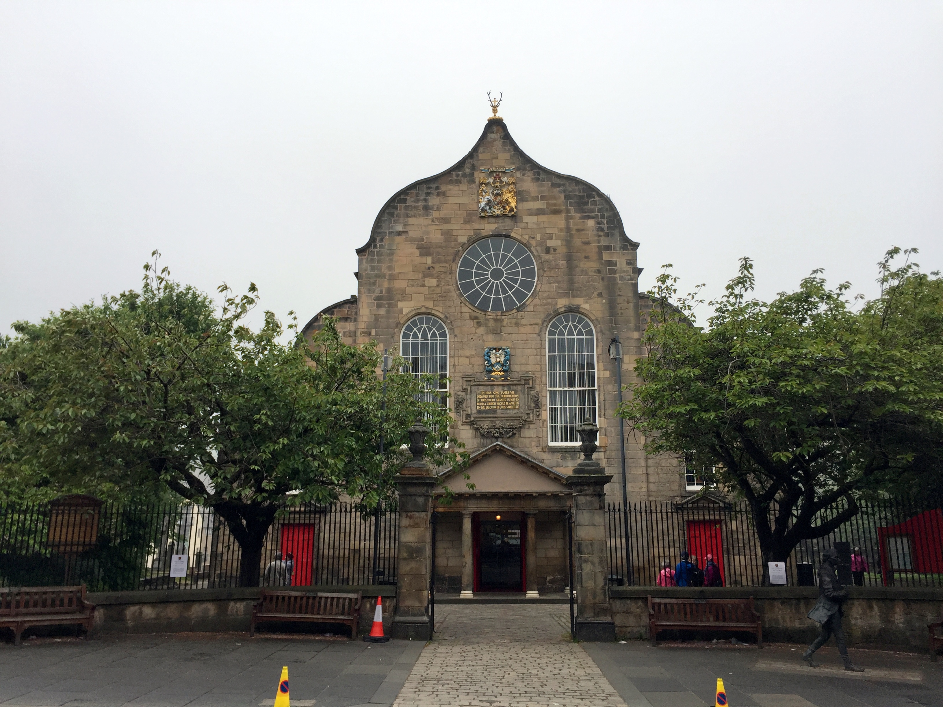
Still further down the Royal Mile toward is the Kirk of the Canongate, which serves as the church for Edinburgh’s Old Town and, more specifically, Holyrood Palace. As a result, this is the royal family’s church when they’re in residence. It’s topped by the same deer-with-a-cross-stuck-in-its-head bust as found later at the gates of Holyrood.
And in the graveyard next door lies Adam Smith’s grave site to accompany his monument up the Royal Mile next to Giles Cathedral:

Scotland’s new and very organic Parliament Building, designed to evoke the highlands (we don’t really see it):


At this point, we’re at the end of the Mile, but Arthur’s Seat was totally fogged in. Although Holyrood wasn’t high on our list to see, we figured we’d pop in and check it out while we waited for the sun to do its work and burn off the fog so we could benefit from a real view at the top of the hill. Holyrood Palace has been the Edinburgh residence of the royal family since the 16th century. The name originally applied to the adjoining Augustinian abbey, which predated the palace, and refers to a vision that King David I had while hunting, where he encountered a deer with a piece of the true cross jutting out of its head (as far as we could discern from our materials, but who knows?). Regardless, there’s a deer head with a cross topping the gate, so there’s that.


A magical unicorn on a nearby wall and the ubiquitous anatomically correct crest atop the entrance to Holyrood House:


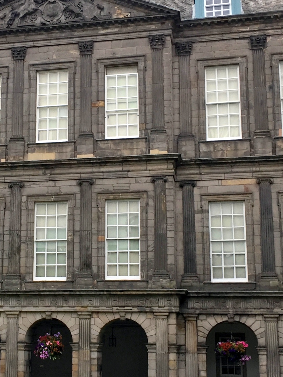
Cloister-like courtyard of Holyrood Palace, featuring what we thought was a pretty cool design element using the capitals of the columns.

As you move up from the ground floor to the third floor, the capitals increase in complexity according to the orders of Greek architecture. The first floor features Doric capitals, the second Ionic, and the third Corinthian.
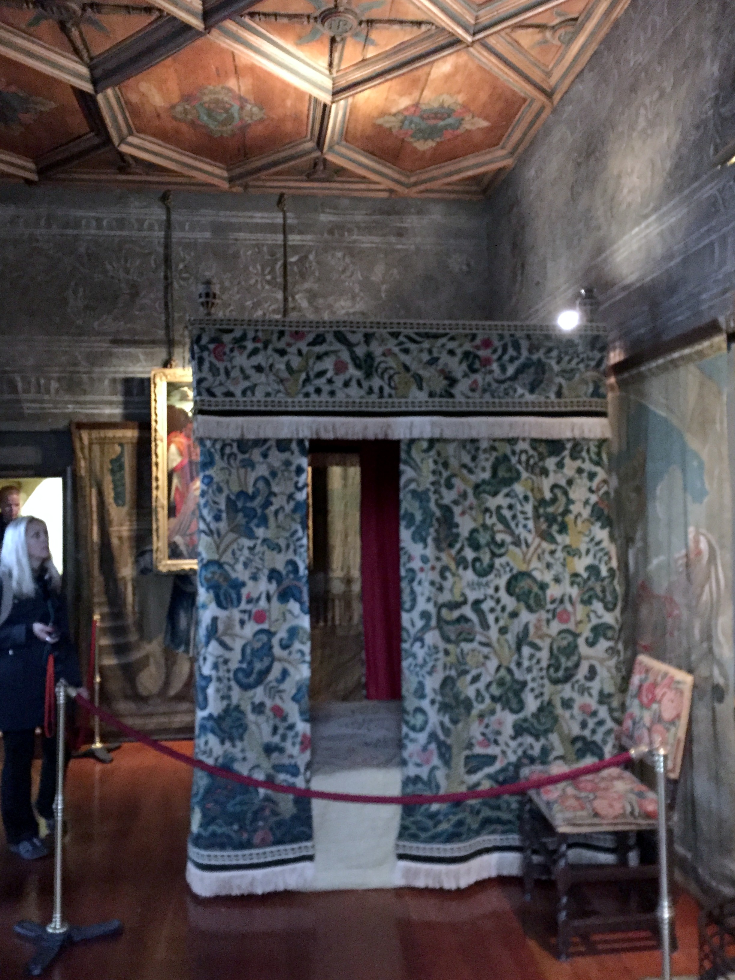
A surreptitiously taken picture of Mary Queen of Scot’s room, from which her advisor was dragged and stabbed to death by Elizibeth’s agents during Mary’s forced residence in the palace (also featured in Ken Follet’s “A Column of Fire,” the last book in the Kingsbridge trilogy (which is really great, if you haven’t read them)):
Adjacent to the palace is the ruined Holyrood Abbey, founded in 1128 by King David I and lying in ruins since the 18th century. Holyrood Abbey was the site of the coronations of James II in 1437, Margaret Tudor in 1504, Mary of Guise in 1540, Anne of Denmark in 1590, and Charles I in 1633.


We took the scenic route through the palace grounds back to the Royal Mile and the trailhead to Arthur’s Seat, and encountered this terrifying nugget of garden statuary:


Ghaa!
Escaping back to the palace courtyard, we ended our tour in front the north-west tower, the oldest section, dating to the 16th century.

We had anticipated that the fog would have burned off Arthur’s Seat after our tour of Holyrood. Nope.

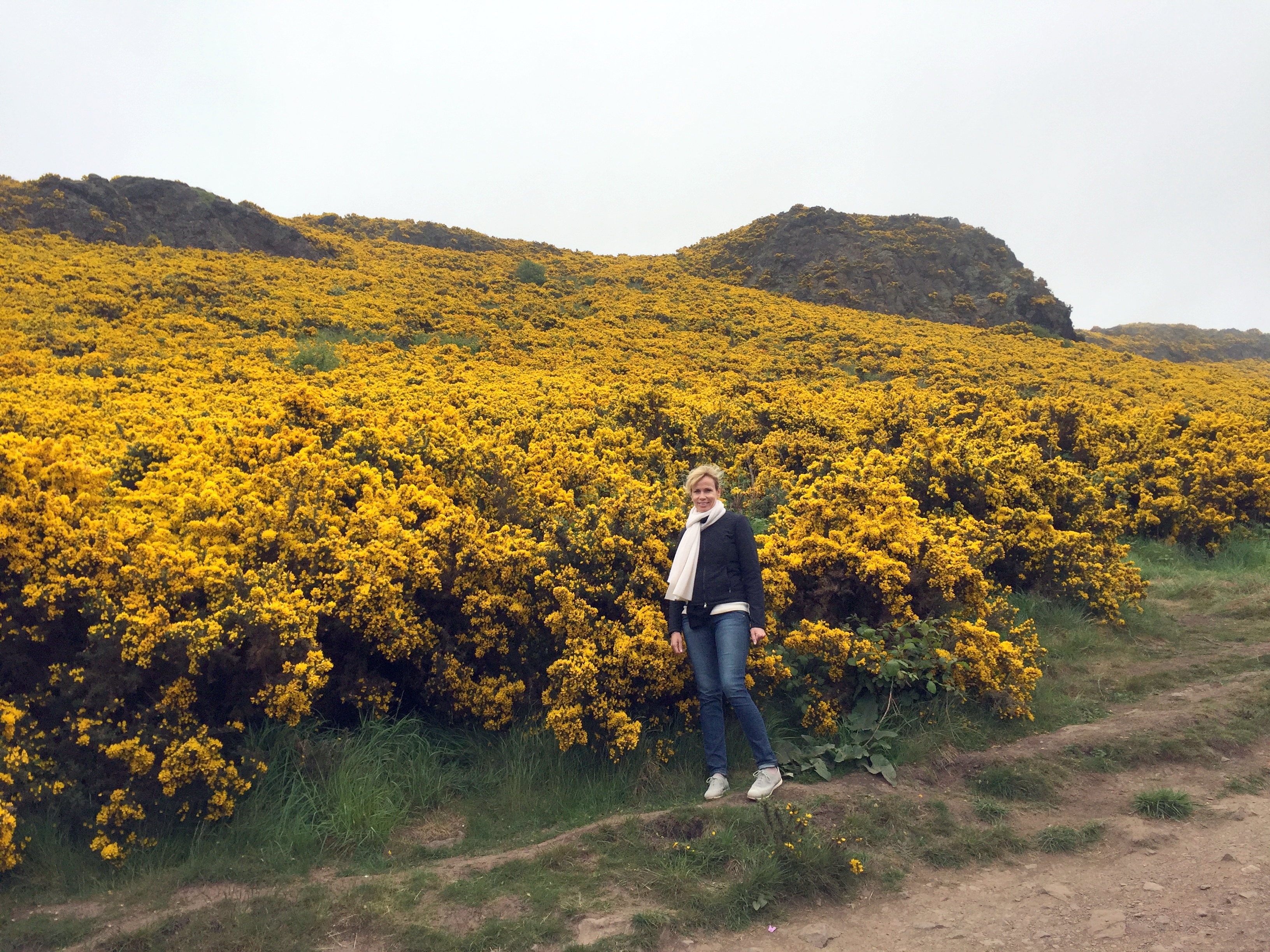
No matter. We began our climb up the extinct volcano with uncertain name origins (don’t assume it’s named after King Arthur, who was, after all, a Welsh or English concoction, not a Scottish one). We were still hoping that the late-morning sun would help us and we’d have our view at the top of Edinburgh. On the way up, we finally got to see what was creating the yellow carpet on the mountain that we saw from Edinburgh Castle – shrubby gorse in full bloom:
Here’s our view from the top:

Seriously! Zero visibility:


Fogged in all the way back down – and nice hair, as a result!


Edinburgh: Upper Mile
Traveling to Mexico and Scotland in the same month turned out to be just the kind of contrast we were looking for in May. The latter trip was prompted by three factors:
- We wanted to travel over Memorial Day
- United just started nonstop service from Dulles to Edinburgh on the Thursday before Memorial Day weekend
- We had never been to Edinburgh
Done!
We traveled on the inaugural direct flight from DC to Edinburgh for a long weekend in Scotland. The allotted time turned out to be ideal – three full days in Edinburgh was just enough time to see everything we wanted to see.
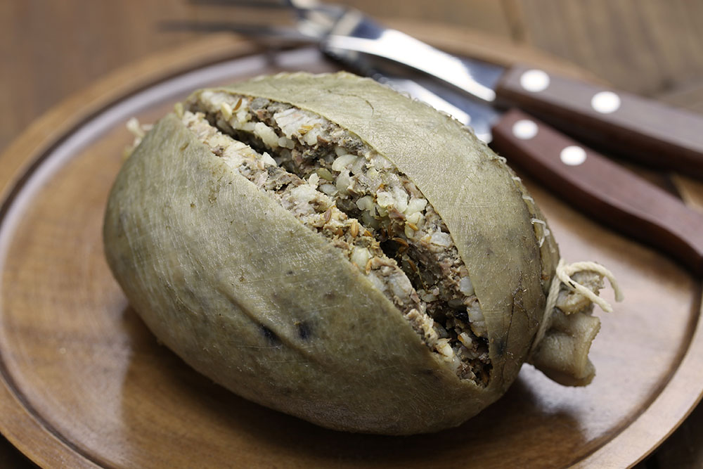
We spent the first day wandering around the upper half of the Royal Mile and into New Town below the castle. We’ll get to that later. Let’s instead focus immediately on haggis, the national dish of Scotland. Haggis consists of a sheep’s or calf’s offal mixed with suet, oatmeal, and seasoning and boiled in a bag, traditionally one made from the animal’s stomach, which looks like this:
Disgusting? Delicious? Who knew?
We lived for years just blocks from Scotland Yard restaurant on King Street in Old Town. We always told ourselves that we’d pop in one evening, brace ourselves, and try this culinary abomination. The years went by, we never took action, and Scotland Yard closed (as well as its sister shop next door – an interminably idiosyncratic wool cape store that we couldn’t believe survived as long as it did).
Now that we were finally heading to the haggis homeland, we were determined not to let another opportunity pass us by. So, our first night in Edinburgh, we ordered it up.
Our haggis from that evening is the brown item on left. It may have been effect of the flight of four whiskeys that we also ordered or it may have been the fact that it was served outside a sheep stomach casing, but it was surprisingly delicious! So much so that we enjoyed it three more times during our trip.

Served traditionally with neeps and tatties (rutabagas and potatoes – left and right on the plate), these starch bombs only enhanced the haggis experience. We could now add our haggis meal in Edinburgh to eating minke whale and puffin in Reykjavik, foal in Ljubljana, and wallaby and Moreton Bay bugs in Sydney.
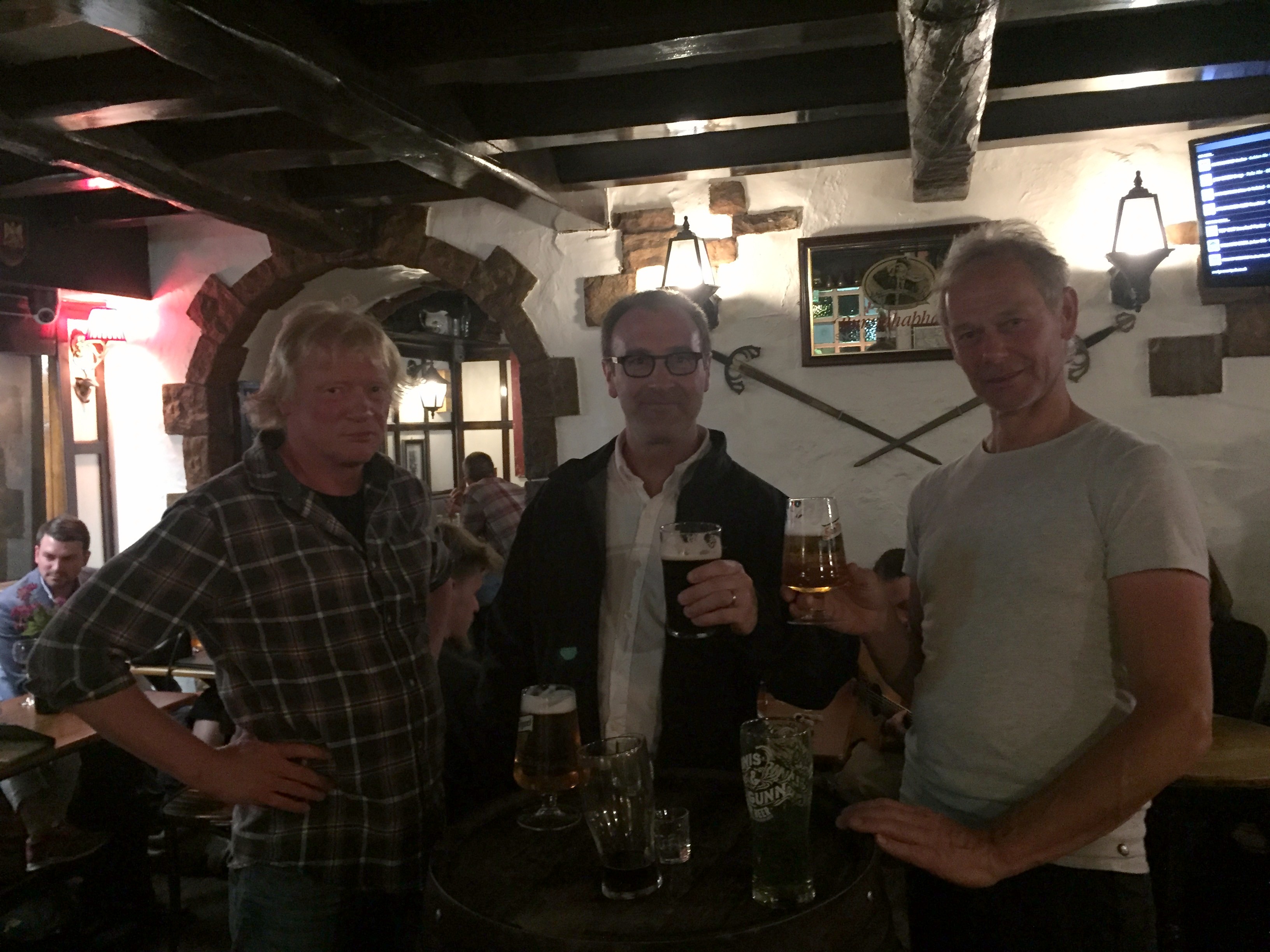
Topping off the evening, we wandered by – then in – a bar with totally casual and awfully good live music:

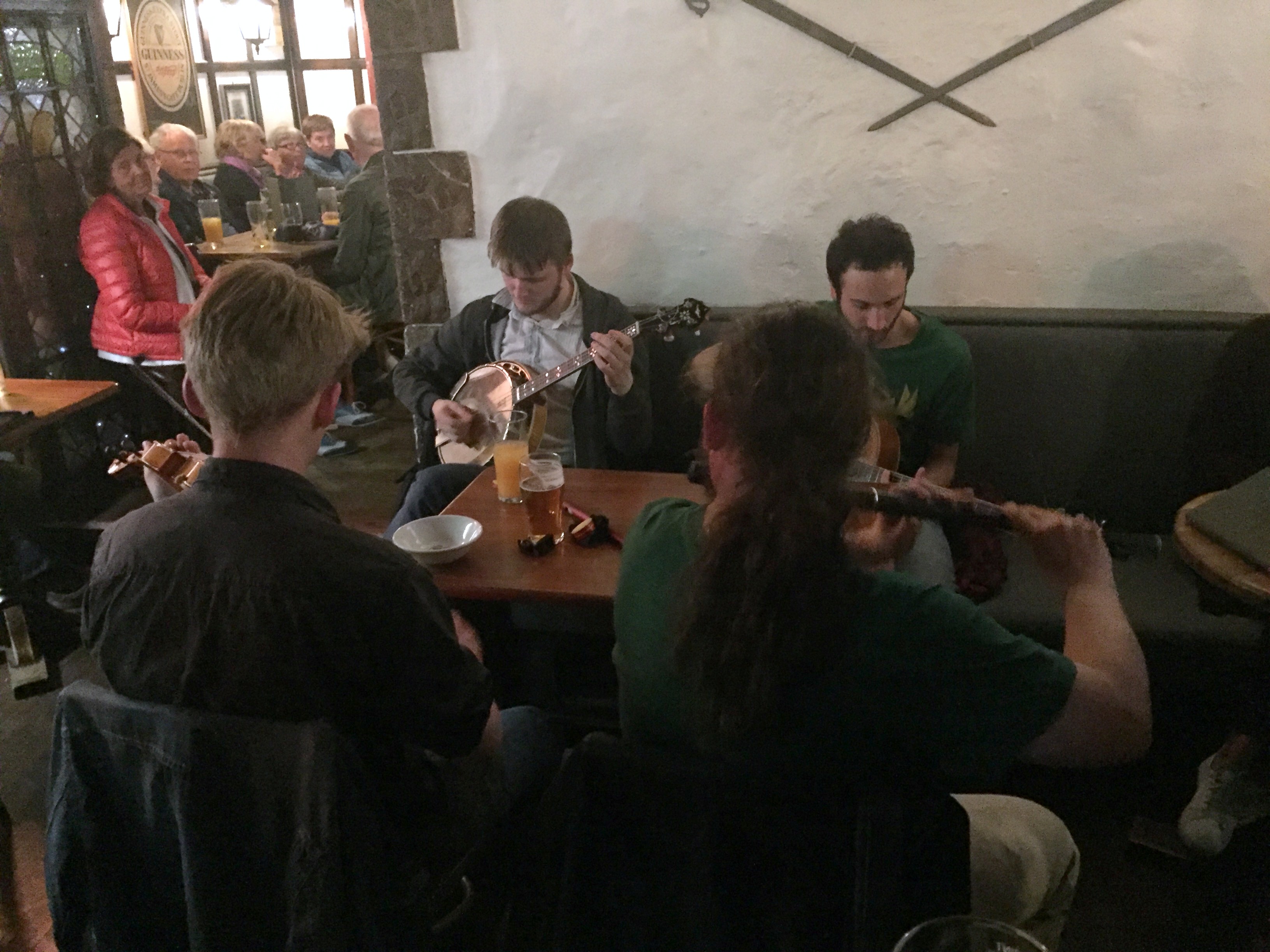
Also in attendance were some Rhinelanders who were passing through town on their way home after hiking the Scottish highlands. We hung out for the evening enjoying the music; all of us liked beer quite a lot, so we got along swimmingly.
The next morning, we headed to Edinburgh Castle at the top of the Royal Mile.

Not fans of mobs of tourists, we procured castle tickets for the opening time before we left the US. One of us indulged the other in getting up (relatively) early to make this happen, and we beat the crowds into the castle. (We’d like to rent out Angkor Wat and Machu Picchu for the day for the same reason on future trips, but still haven’t figured this out.)

Robert the Bruce and William Wallace flank the entrance.


A brief history of the castle, which originated in the 600’s. Saved you a trip!


Following some advice from a travel site researched before we left, we made a bee line to the tower with the crown jewels to avoid being crammed into the Crown Jewels room with the unwashed masses – we were the first there, so the plan was sound.

No pics allowed in the Crown Jewels room, so we took one of the Stone of Scone on the way out. Scottish kings have been crowned atop the stone since the 9th century. Edward Longshanks snagged the stone as a spoil of war in the 13th century and hauled it to London, where it was placed inside the English Coronation Chair, upon which virtually all subsequent English, and then British, monarchs have been crowned, including QEII in 1953. The other occupants of the room include a gold crown dating from Robert the Bruce’s coronation in 1306 and a scepter and sword added to the coronation rite by James IV in the 1500s.

A quick summary of the loss and rediscovery of the crown jewels from this helpful Mental Floss site:
“The Scottish crown jewels are known as the Honours of Scotland and consist of a crown that was remodeled by James V in 1540, a scepter given to James IV in 1494, and the sword of state, which was given to James IV in 1507. The jewels were first used all together at the coronation of all Scottish monarchs starting in 1543, but during the English Civil War, when Oliver Cromwell had Charles I executed, the Scottish crown jewels were spirited away and hidden to prevent Cromwell from destroying them.
The monarchy was restored in 1660, and in 1707 Scotland officially became unified with England under James I. At that point, the historical pieces were placed in storage in Edinburgh Castle for safekeeping. Largely forgotten, they were thought lost until 1818, when the celebrated novelist (and ardent Scot) Sir Walter Scott led a search party through the storerooms of Edinburgh Castle in search of the jewels. Scott stumbled upon a locked oak chest, and there, hidden underneath piles of linen, were the Scottish crown jewels, exactly where they had been left in 1707. Since then the rediscovered jewels have been on display at Edinburgh Castle for all to admire.”
The omnipresent and overtly anatomically correct crest of Scotland, found throughout the castle and all over Edinburgh.


Great Hall of the Royal Apartments, featuring cool armor and arms, including pikes, different styles of halberds (interesting to us inasmuch as we were reading a novel set during the Hundred Years’ War while on the trip), and a kick-ass claymore.


Heading down from the upper castle to the Romanesque St. Margaret’s Chapel, built by Scottish King David in the 12th century as a private chapel for the royal family – it’s one of the only 12th-century structures surviving in any Scottish castle and is the oldest structure in Edinburgh Castle. It was used as a gunpowder store starting in the 16th century, and restored as a chapel in the 19th.
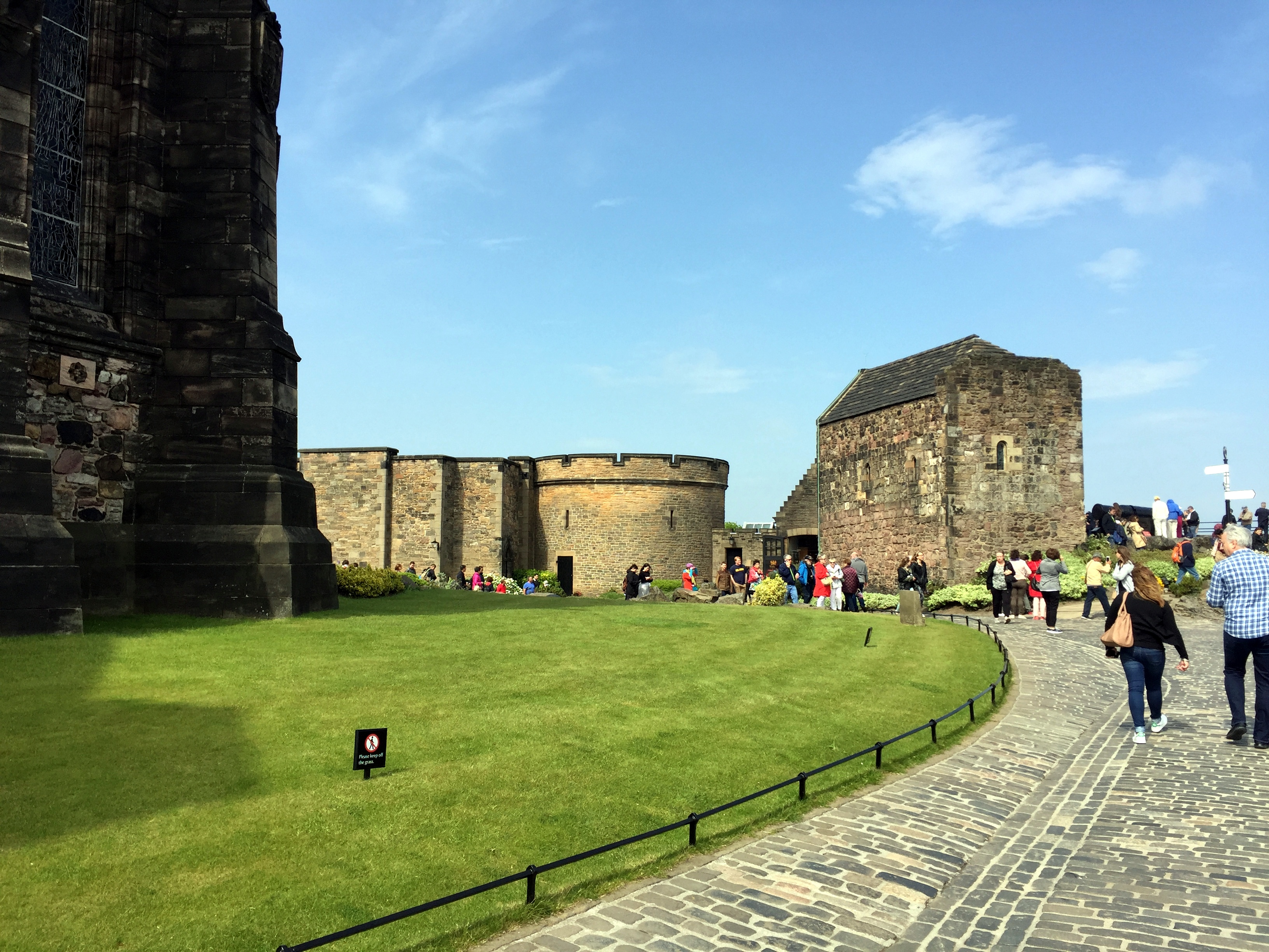

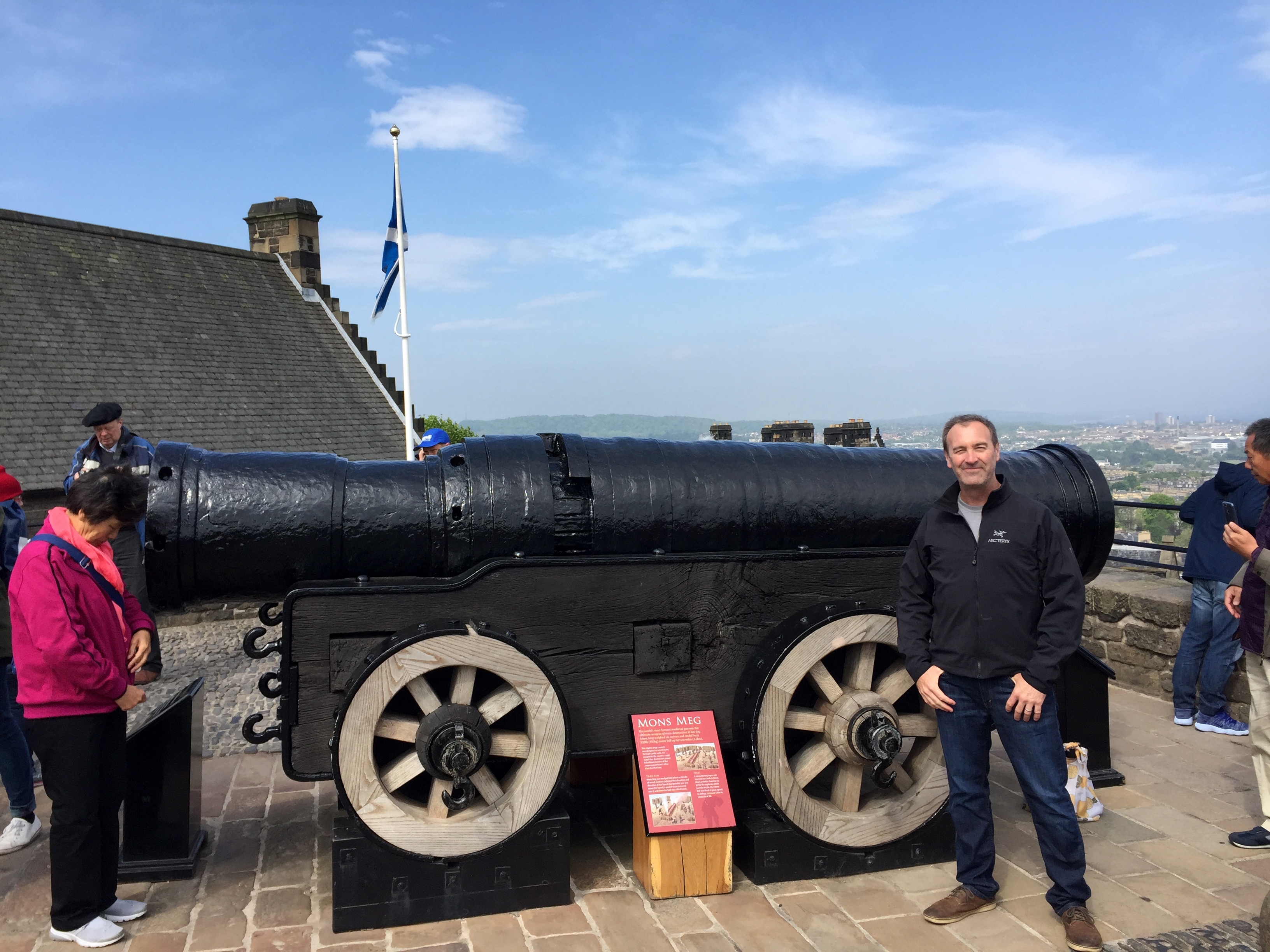
In front of the chapel lies Mons Meg, the castle’s famous medieval bombard and one of the largest cannon in the world, based on caliber (the bore is 20″ in diameter). The weapon was a gift to James II from Philip of Burgundy in the mid 15th century. It was used during sieges for the next century, then was relegated to ceremonial use. The British moved Mons Meg to the Tower of London in the 18th century, and Sir Walter Scott and others lobbied for it’s return in the 19th – which it was.
Inside the cramped, but stark and perfectly Romanesque chapel.

We have no idea what this symbol is on an unassuming stone on a wall in St. Margaret’s Chapel – we took a picture of it while there were people around us to see what would happen; every one of them did the same thing after us, not knowing what it was, but figuring this was something due to the picture. (Seriously, though, if anyone knows what this is, we’d like to know . . .).

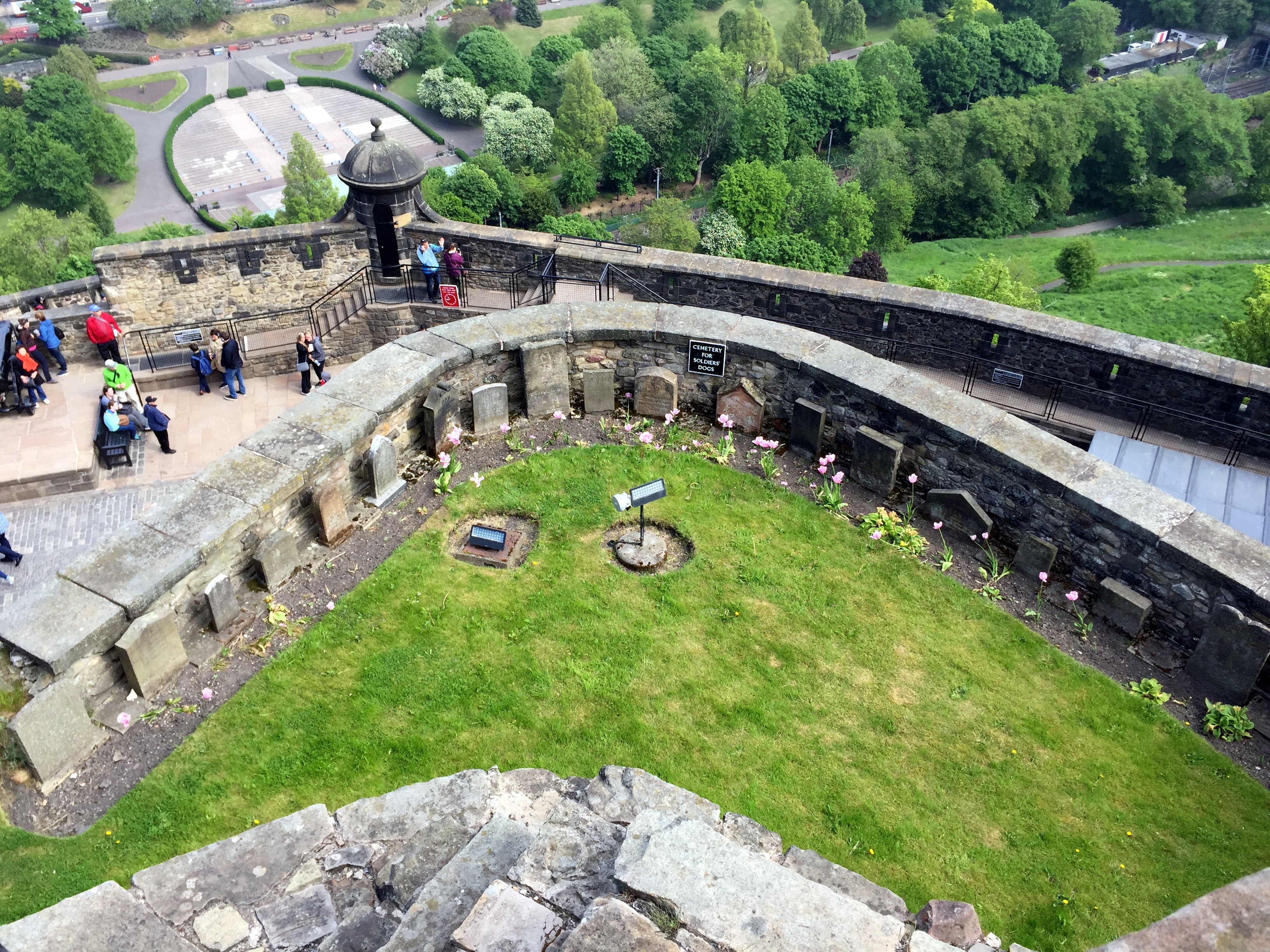
Right over the side near Mons Meg and the chapel is a small burial ground for garrison dogs:
Cannon along the distinctive semicircular Half Moon Battery seen from the town:

With an, uh, helpful arrow to ensure cannon is pointed the right direction?

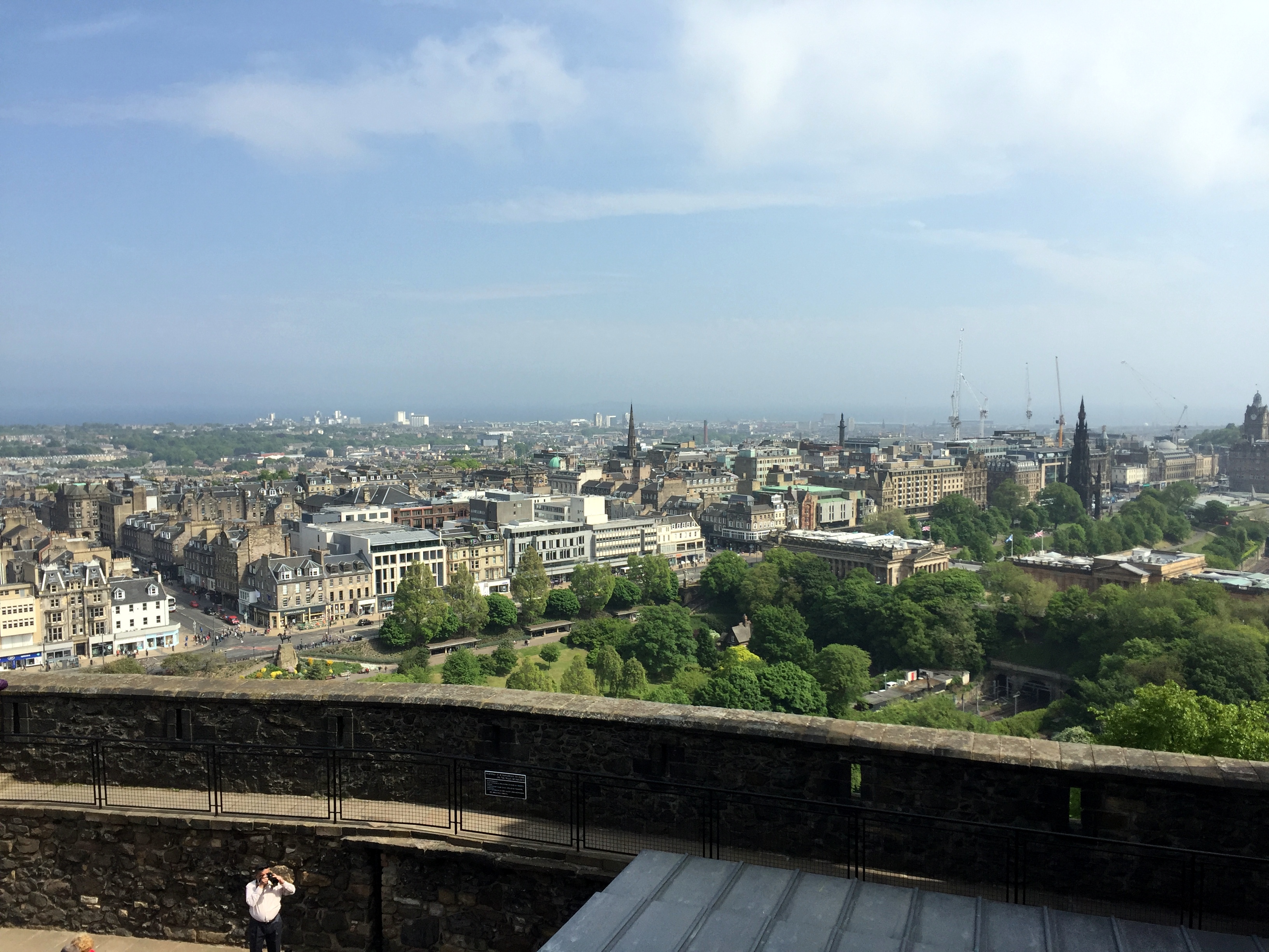
Great view into New Town and the Walter Scott Memorial on the right from the Half Moon Battery:
Uniquely Scottish weapons – plus a remarkably creepy WW I gas mask – from the National War Museum within the walls of Edinburgh Castle


View into town from the other side of the castle.

The castle from the same location below, later in the trip:

View of Arthur’s Seat (the yellow-flowered covered mountain) as we’re leaving the castle. Note the great weather and visibility; not going to be the case for us when we hike it a day later, unfortunately.

A little early lunch after visiting the castle at The Witchery, which had been recommended on the way over to Scotland.

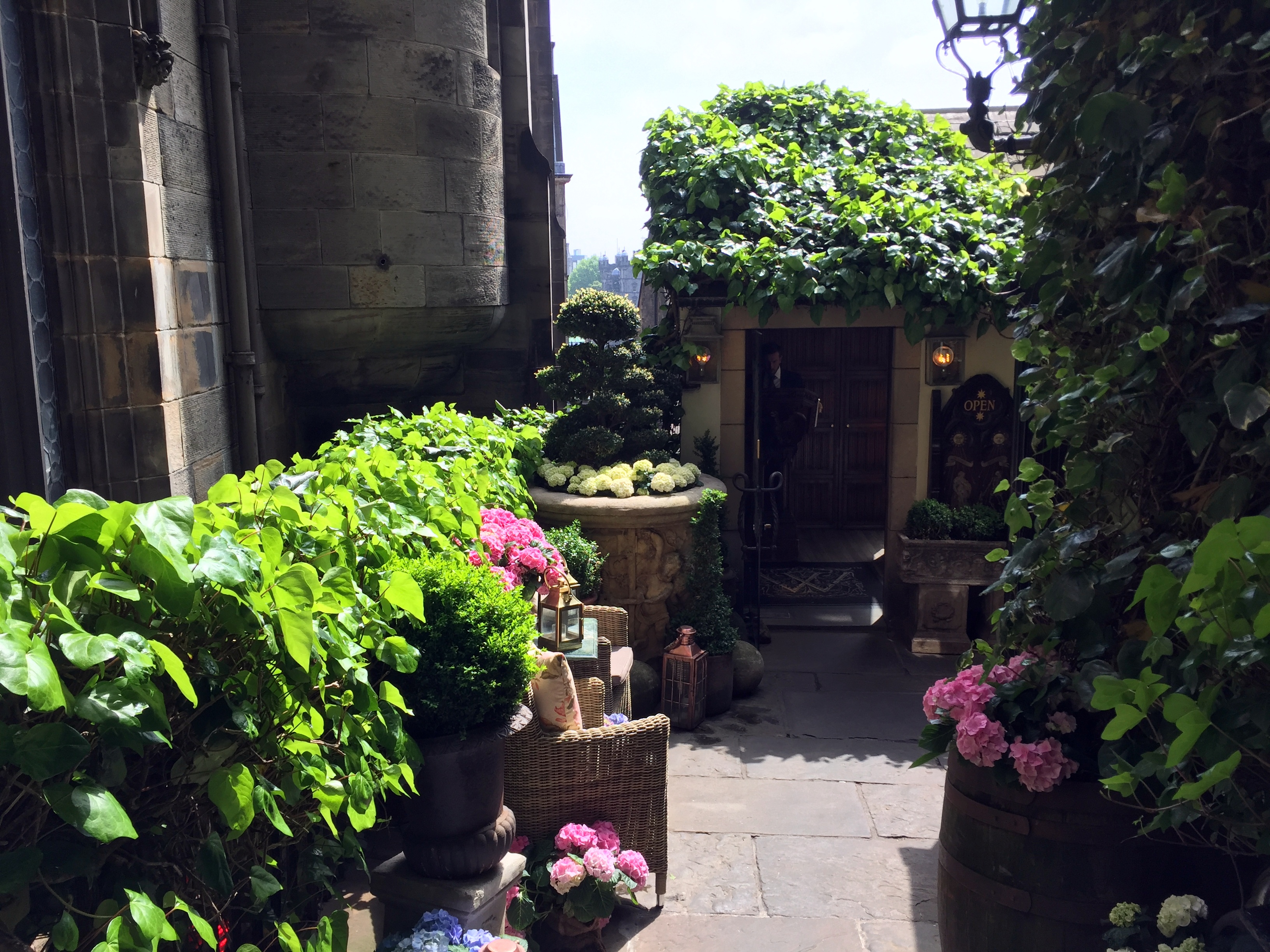
It didn’t disappoint. Haggis #2 and fried neeps, plus an inventive steak tartar and asparagus ravioli.


Scenes from around the upper Royal Mile:


In and around Gile’s Cathedral, Scotland’s version of Westminster Abbey (or of Poland’s Wawel Cathedral, visited a few Christmases ago). Elements of the cathedral date from the 12th century, but the crown steeple is from the 15th. The church features more than memorials to Great Scot!s, including literary greats Robert Burns, Robert Lewis Stevenson, and Edinburgh’s favorite – and omnipresent – son, Sir Walter Scot.


Video taken for Stephanie on the way to the initial haggis dinner – perfect timing and nice atmospherics along the Royal Mile.
