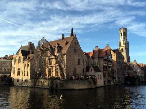
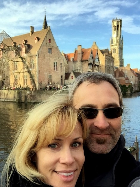
As some have observed, this blog maintains a low-grade obsession with cartography and European history. Although this story is a little light on the former, it’s equipped with some decent elements of the latter. Plus, it centers on Bruges, in Flanders, which we totally dug during a Christmas trip in 2015.
The opportunity for exploitation revolves around a charter granted in 1666 by Charles II of England to a bunch of fishermen in Bruges. Here’s a portion of an article in yesterday’s Telegraph that outlines the brilliant scheme:
“Belgium will invoke a 1666 Royal charter granting its fishermen the eternal right to fish British waters if there is a no deal Brexit.
Boris Johnson has threatened to quit negotiations with Brussels if a trade deal is not in sight by the October 15 EU summit. No deal will hit Belgian fisherman hard because they will face being shut out of British waters.
King Charles II granted 50 men of Bruges the right to fish UK waters for “eternity” after staying in the city during his 1656 to 1659 exile after the English Civil War that ended with the execution of his father.
The regional government of Dutch-speaking Flanders said it would use the ancient charter in the courts if necessary.
“Our goal is to reach a negotiated deal,” a spokesperson for Flemish Fisheries Minister Hilde Crevits told Belgian radio.
“But if we don’t reach a deal, we could invoke the charter. It dates back to 1666 but was confirmed by a UK lawyer in 1820.”
EU boats land about eight times more fish in UK waters than British fishermen do in EU waters. Three quarters of the fish sold in the Belgian port of Ostend are caught in British waters.
“One wonders if it is in Belgium’s, or anyone’s interests to start going back to such historic claims. A lot could get put back on the table,” a British source said.
Britain began fishing negotiations with the newly established Kingdom of Belgium in 1849. A treaty was signed but Belgium insisted at the time it was “without prejudice” to the 1666 “fishing privilege”.
The charter was rediscovered in Bruges city archives by alderman Victor Depaepe in 1963, who wrote to Queen Elizabeth pressing the claim.
Mr Depaepe, an accountant and owner of a fishing fleet, contrived to have himself arrested by the Royal Navy fishing off the coast of East Sussex.
British authorities never brought the case to court, which has fueled speculation prosecutors believed the charter could still be legally enforceable.”
So, one of the planning tools that we didn’t feature in this post on how WolfeStreetTravel plans trips is customizable Google Maps. We bring this up because only because we’re now working on our our third freakin’ map to plan travel over the same Labor Day period, thanks to COVID-19.
We didn’t feature the map on the previous planning post because we hadn’t really used them for planning before – only for tracking completed WolfeStreetTravel destinations on the customized Google Map that’s embedded on the blog’s home (“Map”) page. Customizing Google Maps is useful primarily for road trips in a targeted, but still broad, region, where there is a universe of destination and lodging options that needs to be winnowed down. Visualization of these options in map format with pins applied based on planning research helps to formulate an itinerary.
Unlike the Google map we use to document WolfeStreetTravel destinations on the blog home page, where virtually all destinations are designated by pins that are homogeneous in shape and color, the Google maps we’re using for our now-constantly retreating Labor Day road trip uses uses multiple colors and icons to code the map to designate sources of destination ideas, hotel collections, confirmed stays, and candidate next stops.
We use three monitors for travel planning:
A split screen on one monitor, which enables us to view the customized Google planning map in one half and run a separate instance of Google maps or Rome2rio to calculate drive times and routes on the other (we used Rome2rio to plan the Micronations road trip, as well)
The main monitor for research – Conde Nast Traveler, TripAdvisor, Relais Chateau, Design Hotels, SLH, VRBO, AirBnB, region-specific sites, and other travel blogs
A third monitor to drive the spreadsheet with our evolving itinerary and point-to-point travel tables, as well as additional notes and links
Our plan for the Labor Day period originally was a slow-rolling road trip through the Languedoc region in the South of France, rolling inexorably west, through Cathar country, and ending in San Sebastian, Spain (dropping the rental car back off in Biaritz, France, to avoid ridiculous drop fees that we’d incur if we returned the car in Spain):
Most of the pins designate “The Most Beautiful Villages in France” or similar designations or members of our preferred hotel collections. The primary source of beautiful villages is an officially sanctioned list produced by the French government. “There are 161 villages in France rated as a Plus Beaux Village (as of 2013). The ratings are awarded by the Plus Beaux Villages de France association. The basic requirements to be considered by the association are: population under 2000, at least two village sites or buildings classified as “protected”, and the municipality requests that the village be considered.“ Others originate from regional tourism boards or reasonably referenceable travel blogs that we’ve vetted (there are innumerable shit travel blogs out there). Purple bed pins represent lodging that we had reserved, question marks potential next stops, etc. This trip was 50% done in February when COVID hit; we held out until May, then threw in the towel. Since then, of course, France, as well as the rest of Europe other than Ireland, has declared American travelers persona non grata – understandably so, since the country’s a shitshow with no national strategy.
So, we retrenched. To New England. We’ve wanted to spend time there – and in Maine and Prince Edward Island, in particular. Unfortunately (but reasonably), both Canada and Maine restricted travel from dipshit areas of the US that were out of control, so the northernmost destination targets were now off limits. Based on the laxer travel requirements in other areas in New England, we’d now head north through New York, Rhode Island (we’ve never been), Massachusetts, New Hampshire (we’ve never been), then over to Vermont, down through Pennsylvania, and home. This Google map shows the progress we had made on the backup plan:
But now, New York (our first stop) is (again, understandably) conducting checks on out-of-state travelers on key “key entry points,” to help enforce quarantine requirements. For Rhode Island and New Hampshire, we’d need to quarantine the entire time (which pretty much eliminates the benefit of staying in Newport or Portsmouth, which is where our lodging is located) or produce a negative COVID test taken within 72 hours of entry. Regardless of the challenge with the 72-hour timing (we’d be leaving Virginia more than a week before we hit New Hampshire, for example), there’s no way of knowing when the test results would be available. For Rhode Island, where we’d arrive maybe 68 hours after leaving Virginia, we still may not get a result until after we left for Massachusetts, resulting in quarantining in a cottage the entire time. Not bad digs, since it’s Castle Hill Inn, but not leaving your cottage would get pretty old after the first few hours.
So, starting last Thursday, we’ve had to cancel the four lodging reservations we had in New England, plus a round-trip ferry to Martha’s Vineyard, which does not appear to be (cancellable, after all), and start to plan what we’re optimistically calling the Mid-Atlantic Road Trip:
Based on what’s going on in the country, it’s probably going to wind up simply as the Alexandria circumnavigation-by-bike trip. . .
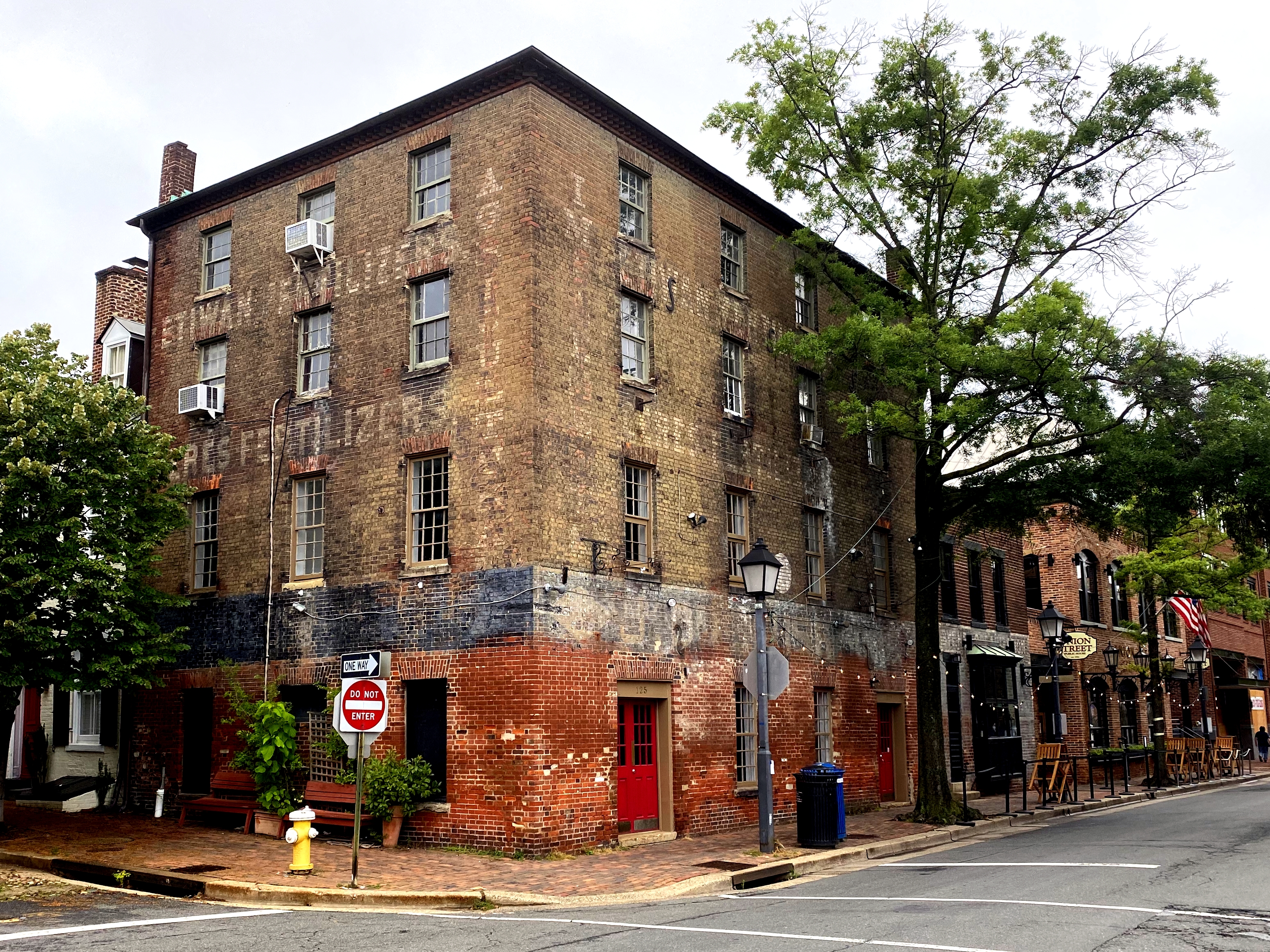
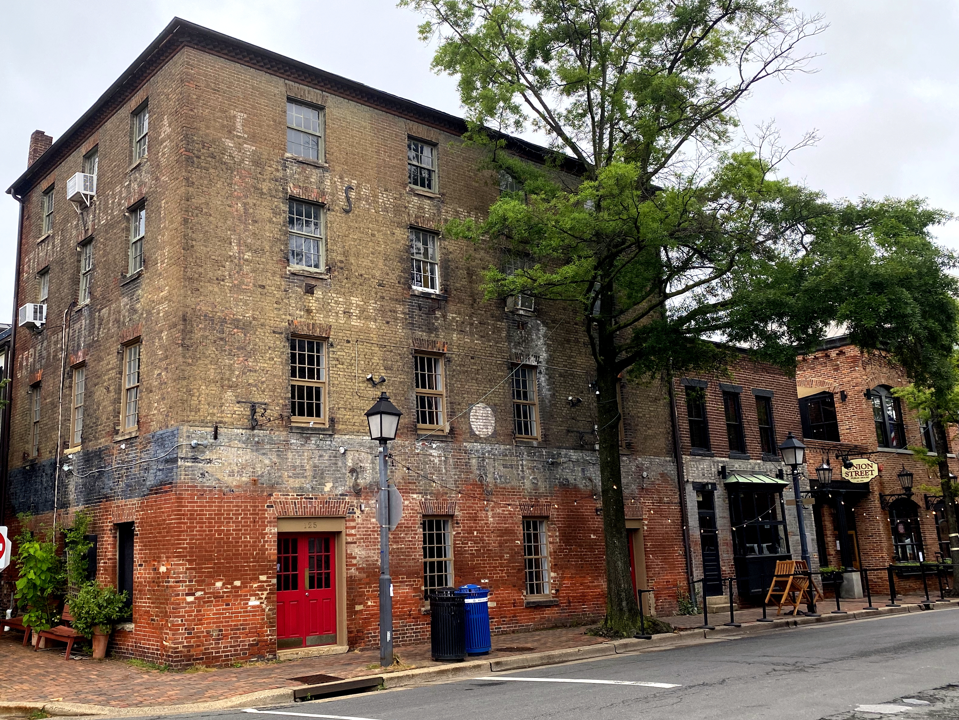
Alexandria’s history dates back to 1749, and the older, brick buildings in our town, particularly along Union Street, have been repurposed many times over the centuries. This included commercial uses where a little in situ advertising on their walls would have benefited sales of their goods. Although these buildings now generally house restaurants and more tourist-oriented shops, there are faded reminders of their previous lives still visible on their facades – ghost signs.
The most visible is likely this building on the corner of Prince and South Union:
Formerly the home to “ETIMAN FERTILIZER” and “CERES FERTILIZER,” according to the ghost signs on both the south and east facades,
It was for a few decades the home of The Christmas Attic, but that business, too, has gone the way of Ceres Fertilizer, and is no longer there. We’ll see who moves in next.
Just north on an adjacent building is the former home to BYRNE ORGANIZATION:
We have no idea what this is, but would like to think that it was Alexandria’s Irish mob version of the Bada Bing in the Sopranos. Regardless, it’s now the whiskey room portion of Union Street Public House.
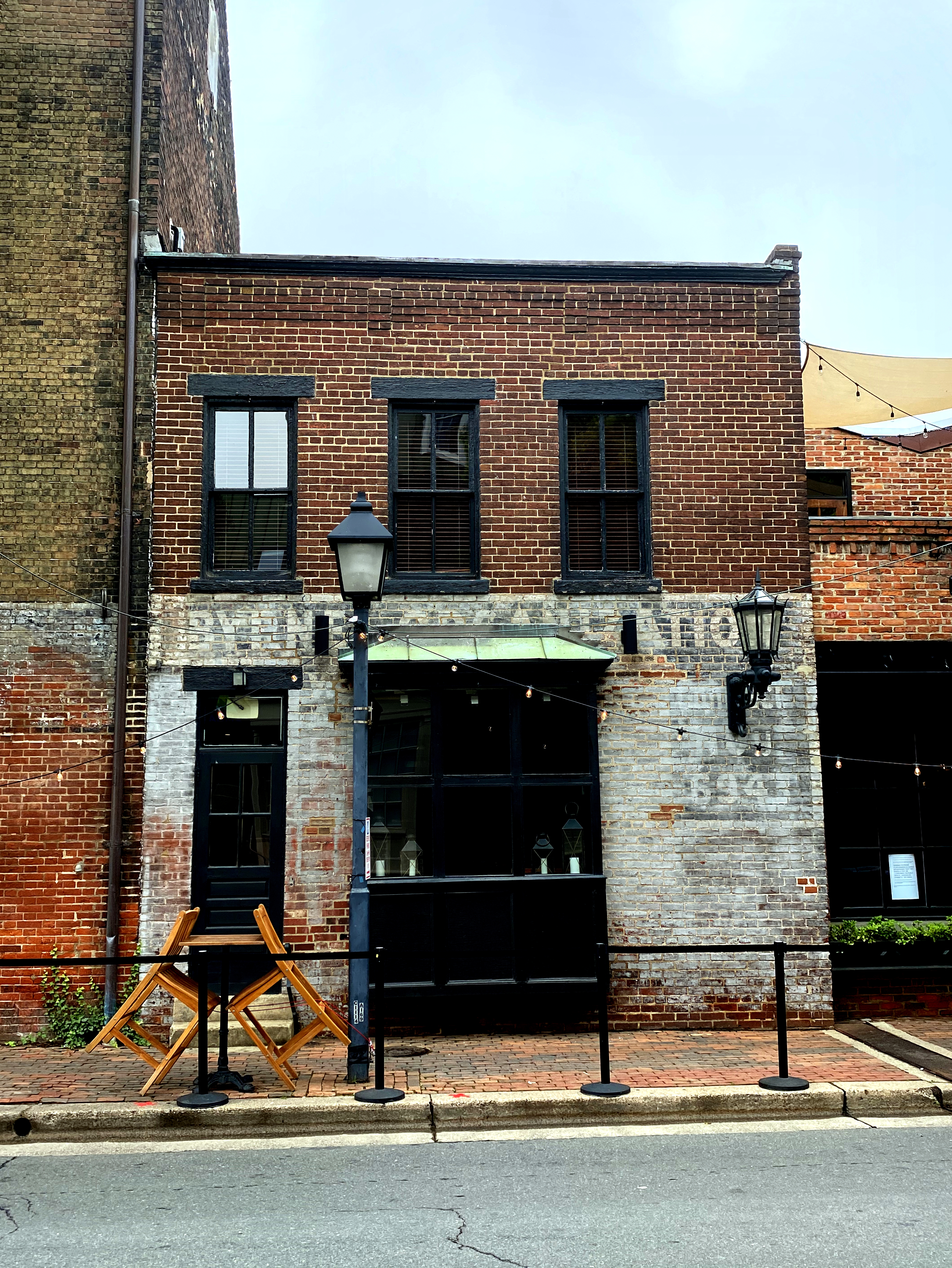
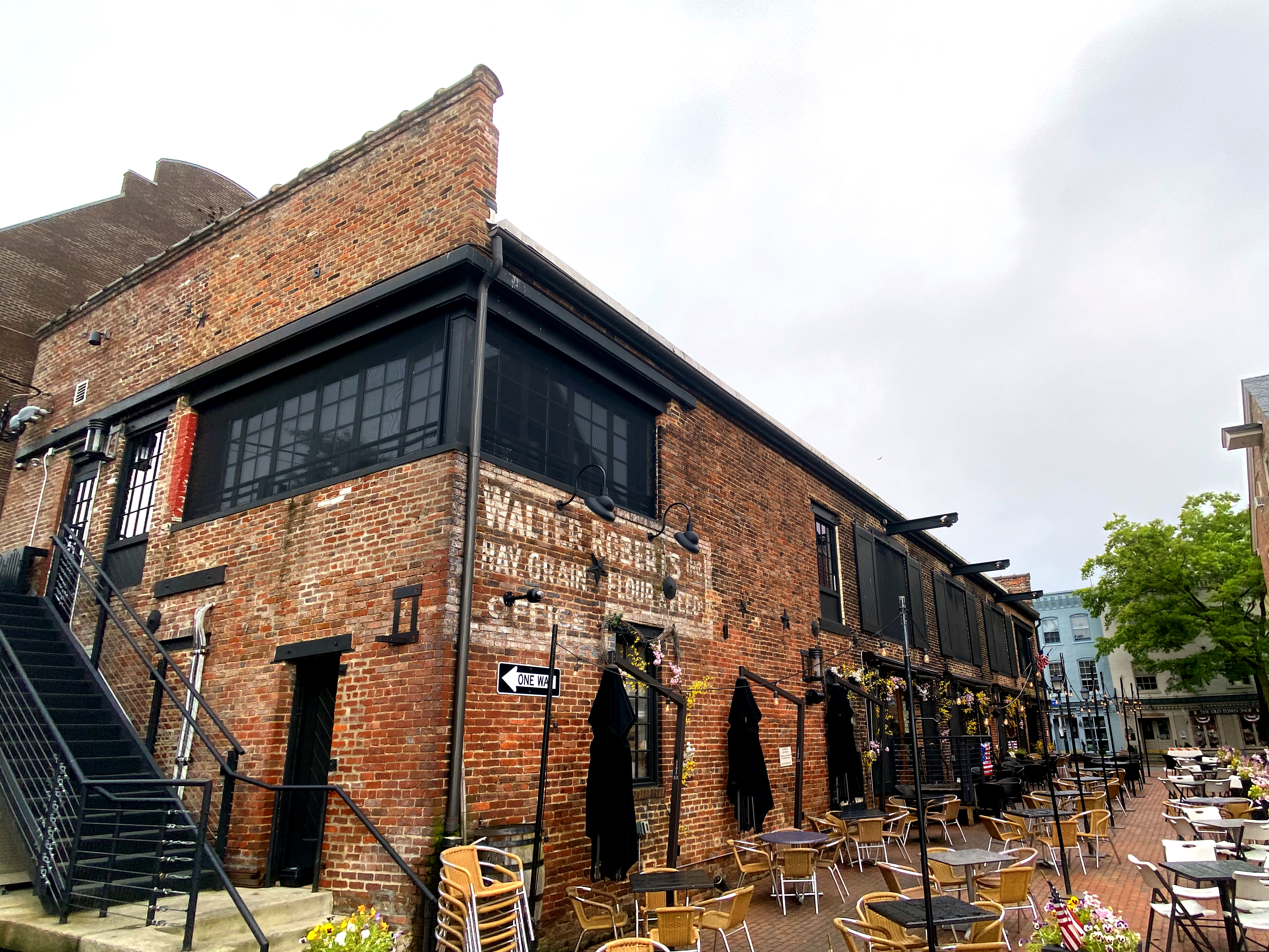
Across the street is Virtue Feed & Grain restaurant and bar:
At some point in the past, this was “WALTER ROBERT’S HAY, GRAIN, FLOUR & FEED.” The building also was home to the actual Virtue Feed & Grain store, and we thought there was a ghost sign for this that inspired the restaurant’s name, but it’s not visible now.
A ghost sign that we didn’t even realize was there until recently, despite walking or running by the place hundreds of times, can be found on the corner of Duke and Fairfax:
This was once a corner store, which, prior to the 1960s and the advent of the supermarket, occupied most corners in Old Town (including both ends of our block of Wolfe Street). The last of them – a deli on the corner of Fairfax and Franklin – succumbed to residential conversion about a decade ago.
As with many of the former corner stores, now residences, you can tell that they once served a commercial purpose – this one based on the store windows. The ghost sign can be found between the two windows on the second floor.
“GROCERY SPECIALTIES”
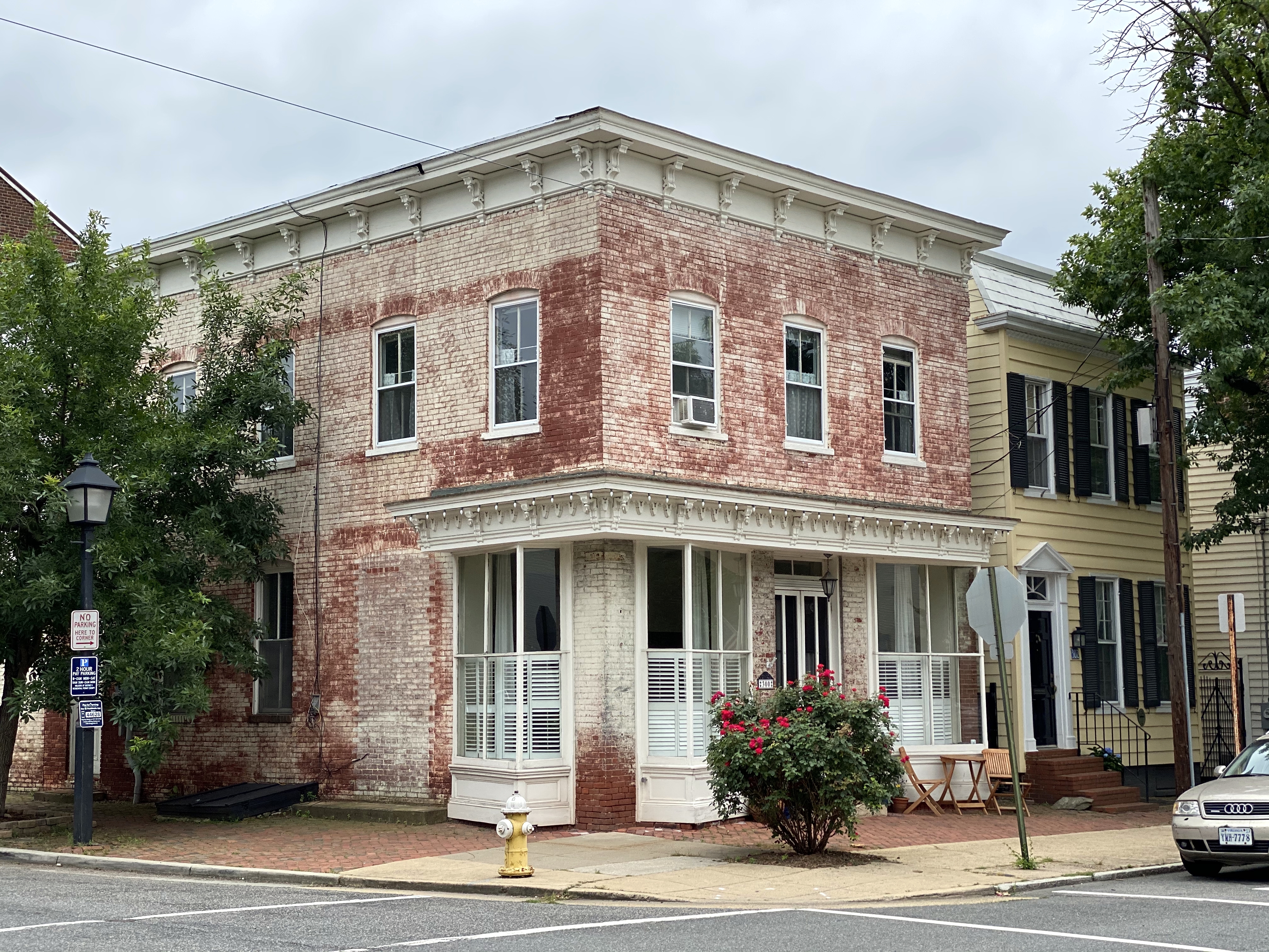
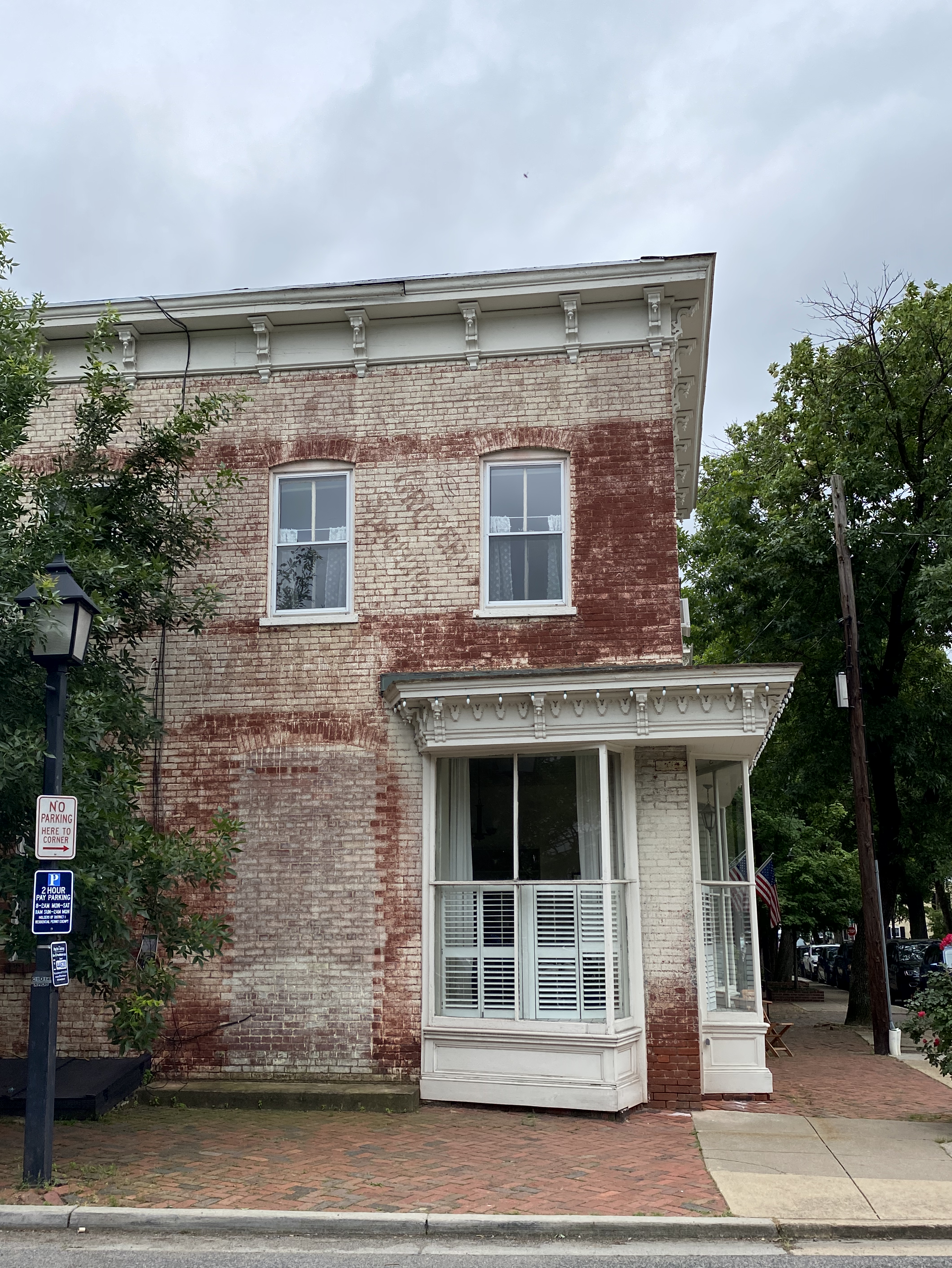
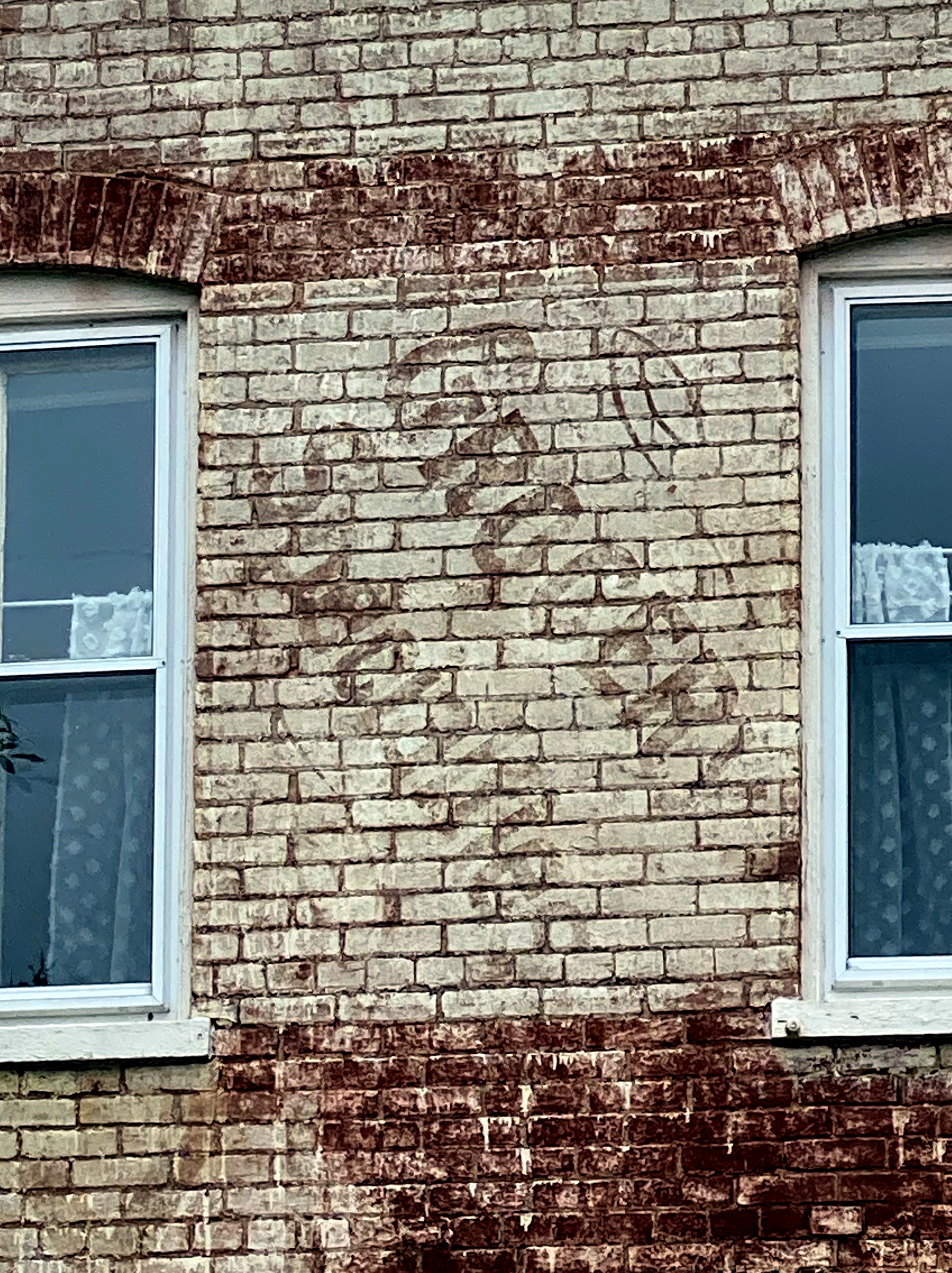
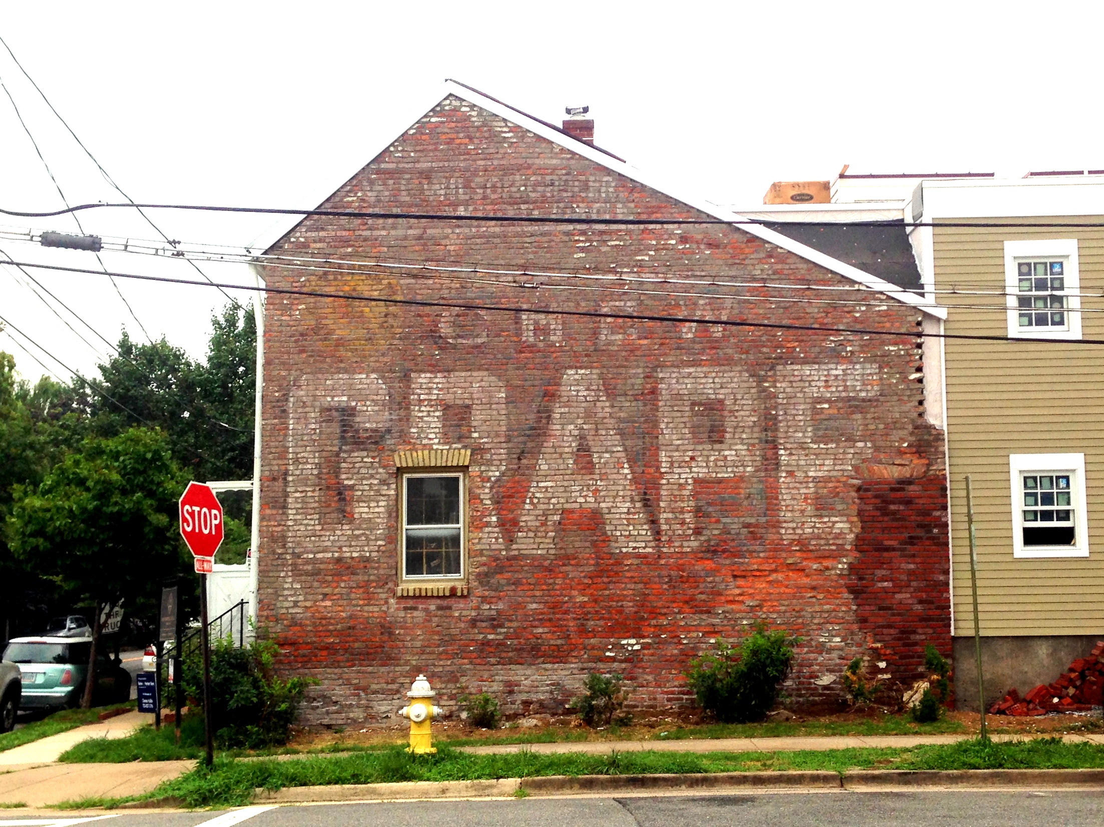
The most recently uncovered is undoubtedly the coolest – the Grape house on the corner of South St. Asaph and Gibbon:
The house was built in 1842, and for our entire residency in Old Town, this wall was painted. However, the house underwent a comprehensive renovation in 2015, including stripping the old paint from this wall, revealing a chewing tobacco advertisement. Wisely, the wall was left exposed. We assume that it actually added a premium to the house price, considering how prominently the Grape tobacco ad was featured in marketing for the house when it was sold.
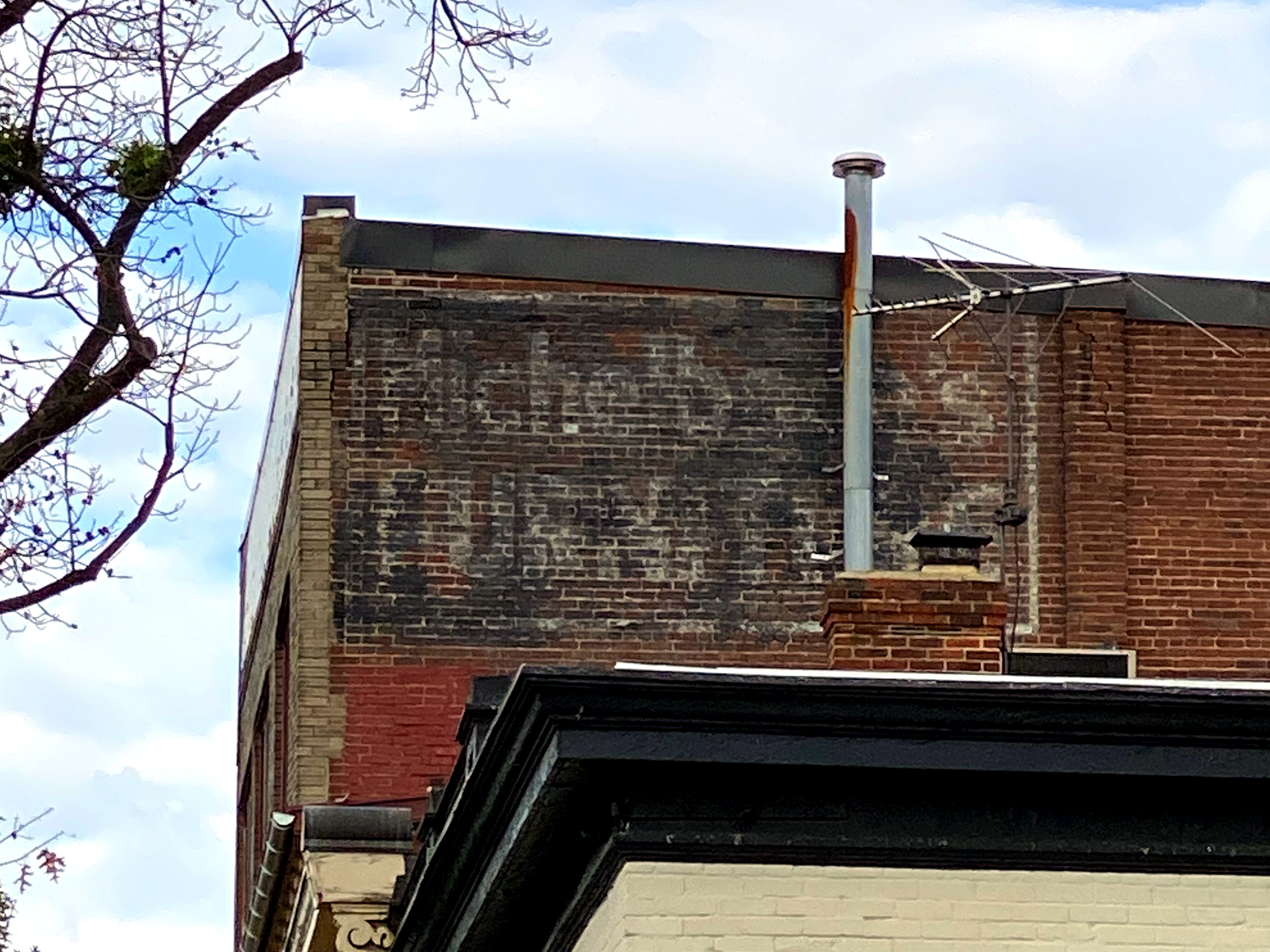
All of these ghost signs are located in the southeast quadrant. There’s one in the southwest on the top floor of a brick building on King Street:
“Michelbach’s Furniture”
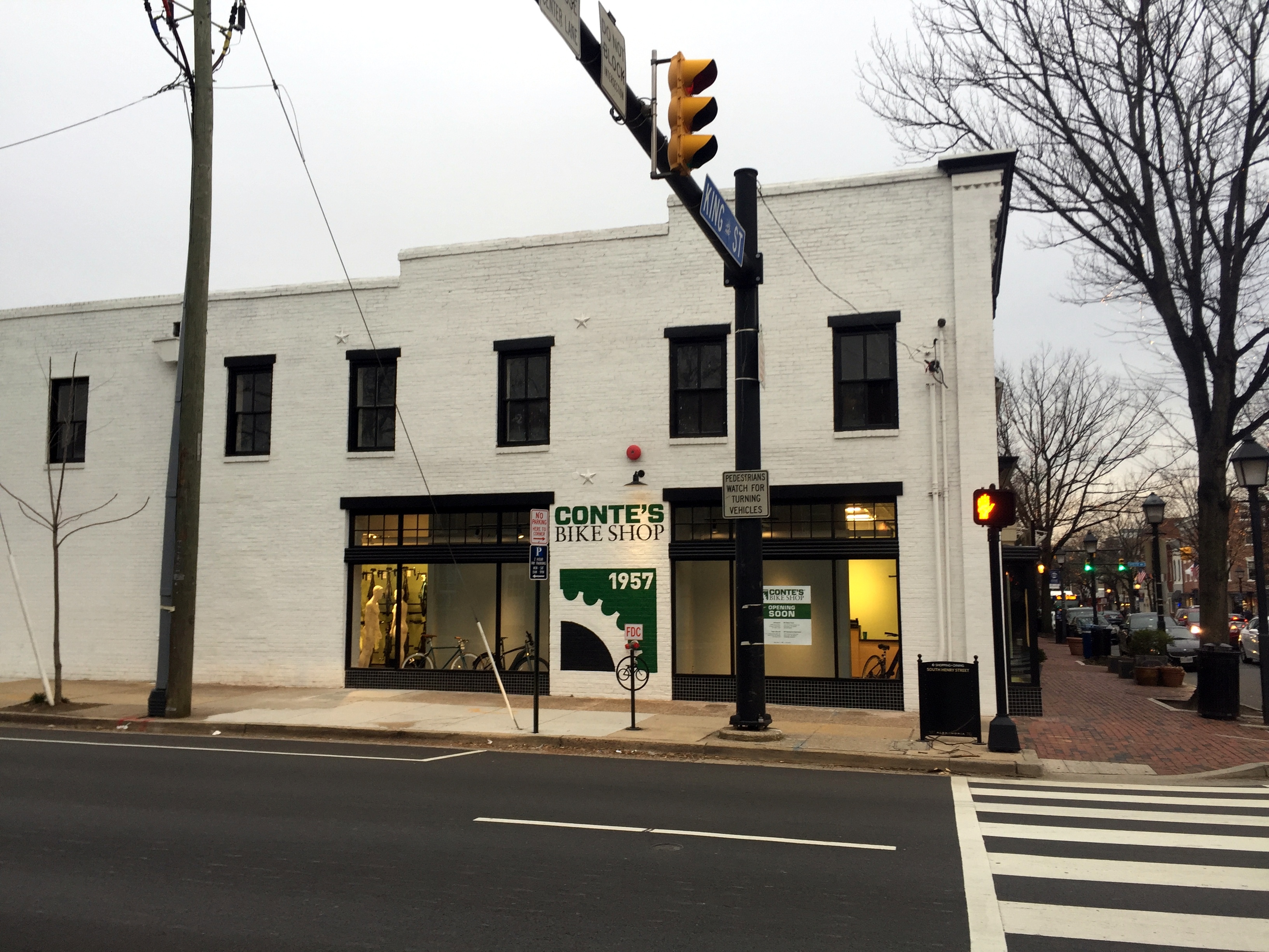
And perhaps a future ghost sign on the side of the new location for Conte’s Bike Shop:
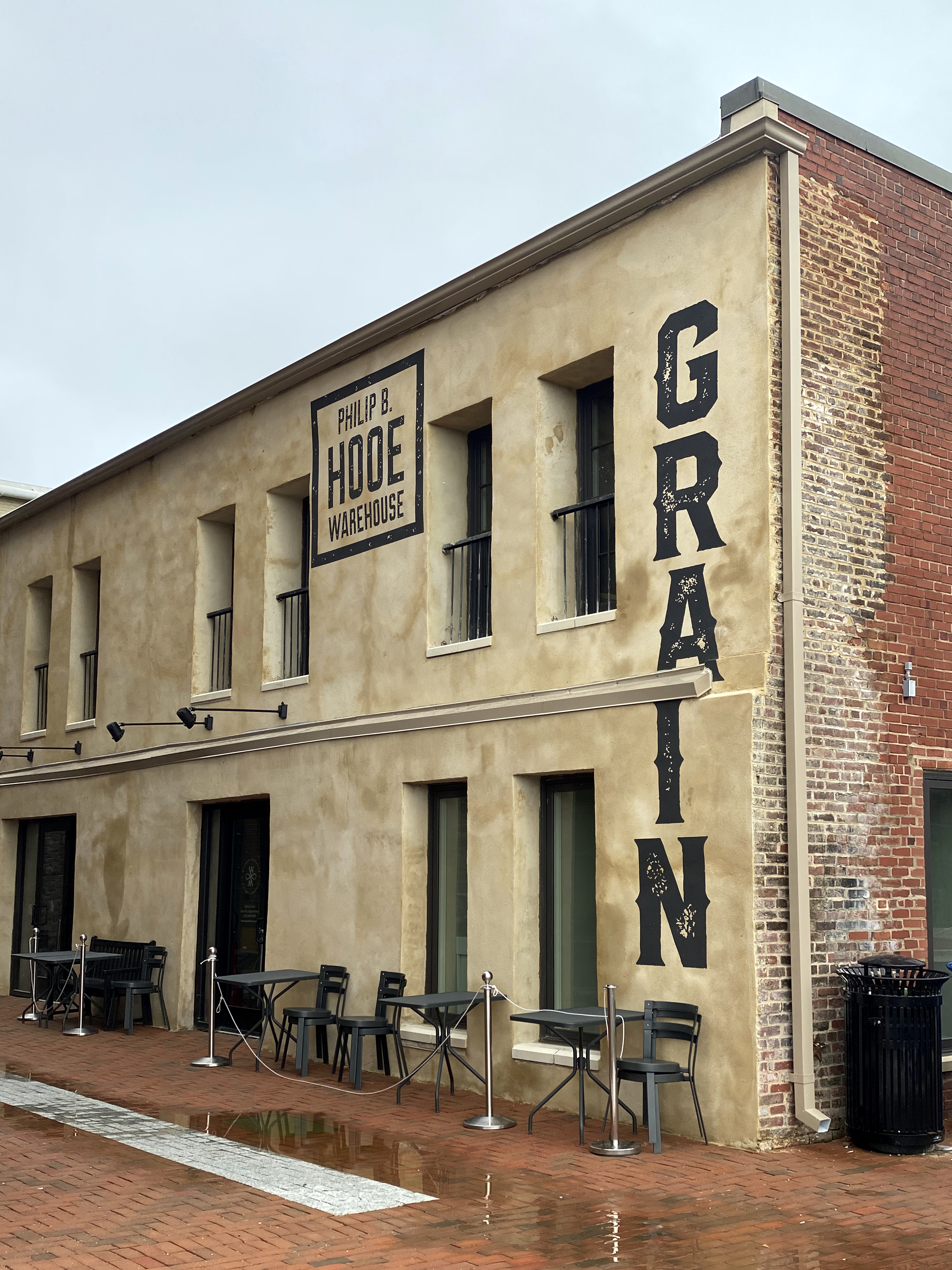
And, lastly, a fake and hokey Oldey Timey sign that the developers of the Watermark condos put up on the Strand:
We have no doubt that this structure (which used to be the sales office for the Potomac River cruise ship The Dandy) was at one time the PHILIP B. HOOE WAREHOUSE for GRAIN, but the oldey timey font is a bit much.
The tables, btw, are overflow outdoor seating for Chadwick’s around the corner (a true Old Town institution). The city has permitted restaurants to spill out into the streets and alleys to accommodate outdoor dining during the current restrictions, which is absolutely awesome. If you haven’t been out to a restaurant since February and are hankering to dine out, come to Old Town!
That’s right – Vanilla Ice knew his Old Town ice houses. There are exactly two ice ice houses in Alexandria, down from dozens across the city at the turn of the 20th century.
Neither are used for storing and selling ice anymore, but this summer, according to Alexandria Living Magazine, a company called Goodie’s Frozen Custard will be moving into the more iconic of Old Town’s two extant ice houses. After 30 years as a plumbing supply shop, and then being abandoned for more than a decade, that ice house will soon host a tenant worthy of the space.
Between 1900 and 1930, ice houses in Alexandria distributed hundreds of thousands of tons of ice annually to the city’s businesses and residents. The increased availability of electricity throughout the city after this period rendered the ice houses obsolete. Most were demo’d to allow the construction of new structures. But two remain standing, albeit used for other purposes.
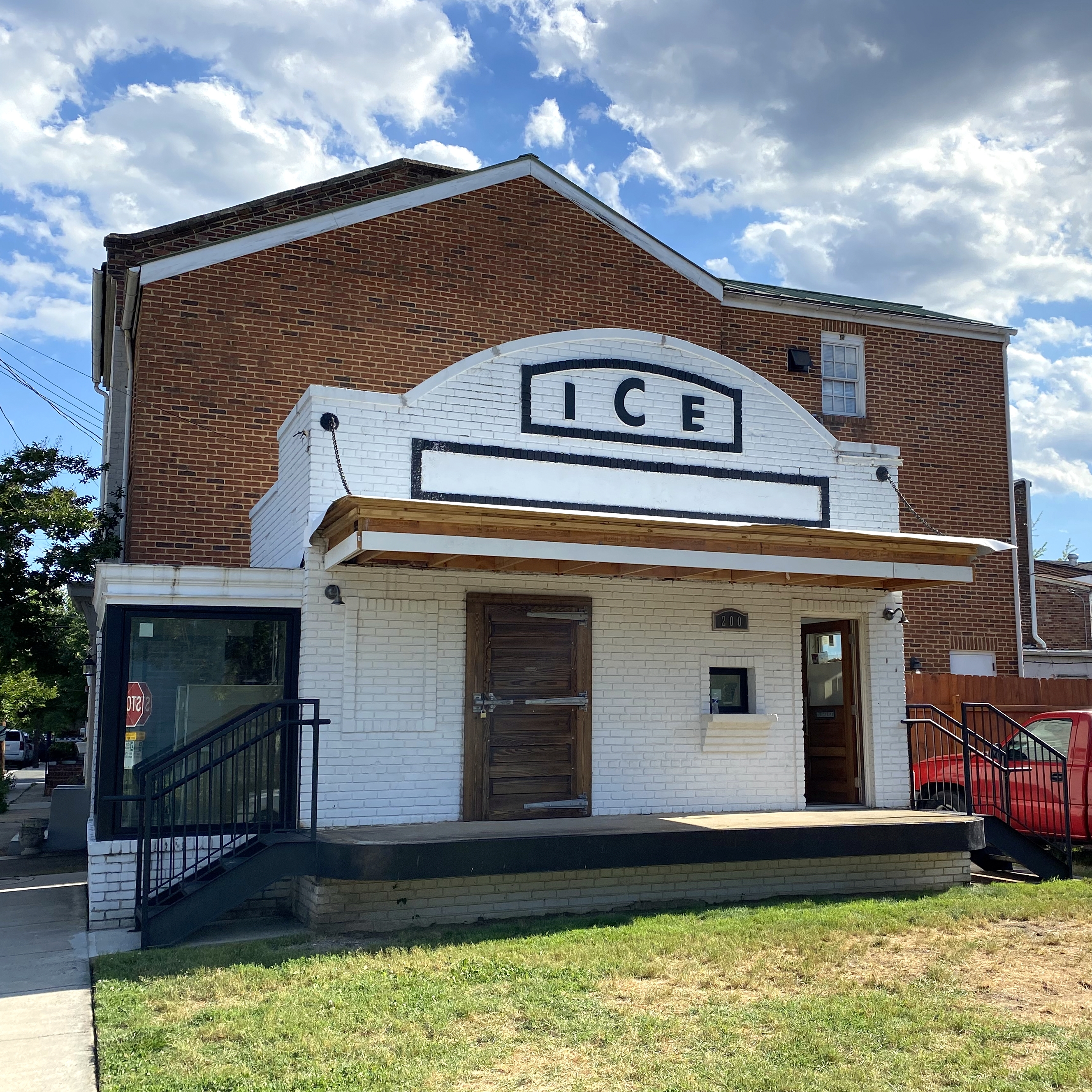
The more well-known of the two (and the one for which its function is unambiguously broadcast), is located in the southwest quadrant, on the 200 block of Commerce Street (and visible from King):
When one of us was growing up, that ice house was abandoned, and painted a uniform, faded light blue. The “ICE” was visible only as relief on the facade. (BTW, we continue to look for a serigraph of the ice house in this condition by late, local Torpedo Factory artist Clay Huffman, but the search has been fruitless.) About 5 years ago, someone bought ICE house, began restoring it, and applied the new, improved paint scheme. This is the future home of the frozen custard purveyor, fittingly enough.
The other remaining ice house structure lies on the 100 block of South Lee Street:
We run or walk by this place multiple times a week, and only recently realized that it was an ice house. This was the home of the Mutual Ice Company from 1900 to 1937, when it closed due to widespread adoption of electricity for refrigerators and freezers. It’s now home to an architectural firm.
As with the first “ICE” house, the structure on Lee features a shelf on which to place ice blocks during a transaction:
And a pretty impressive, heavy wood insulated door to the ice freezer:
These more recent ice houses have nothing on the grand daddy of them all in Old Town, though – the 18th-century Gatsby’s Tavern ice well. (All of the quoted information below is verbatim from the city’s historical information site here.)
“The Alexandria Common Council granted Wise permission to build an icehouse underneath the corner of Royal and Cameron Streets in 1793 as part of his construction. For the previous four years, Wise had leased the Alexandria Inn and Coffee House at 201 N. Fairfax Street, which included an on-site icehouse. Perhaps this convenience in his earlier ventures convinced Wise of the importance to the hospitality industry of having a regular supply of ice. Wise saw into the future by including this important feature in his designs for Alexandria’s five-star hotel of the 18th century.”
Inscription on the bluestone at the center of the circle on the corner above:
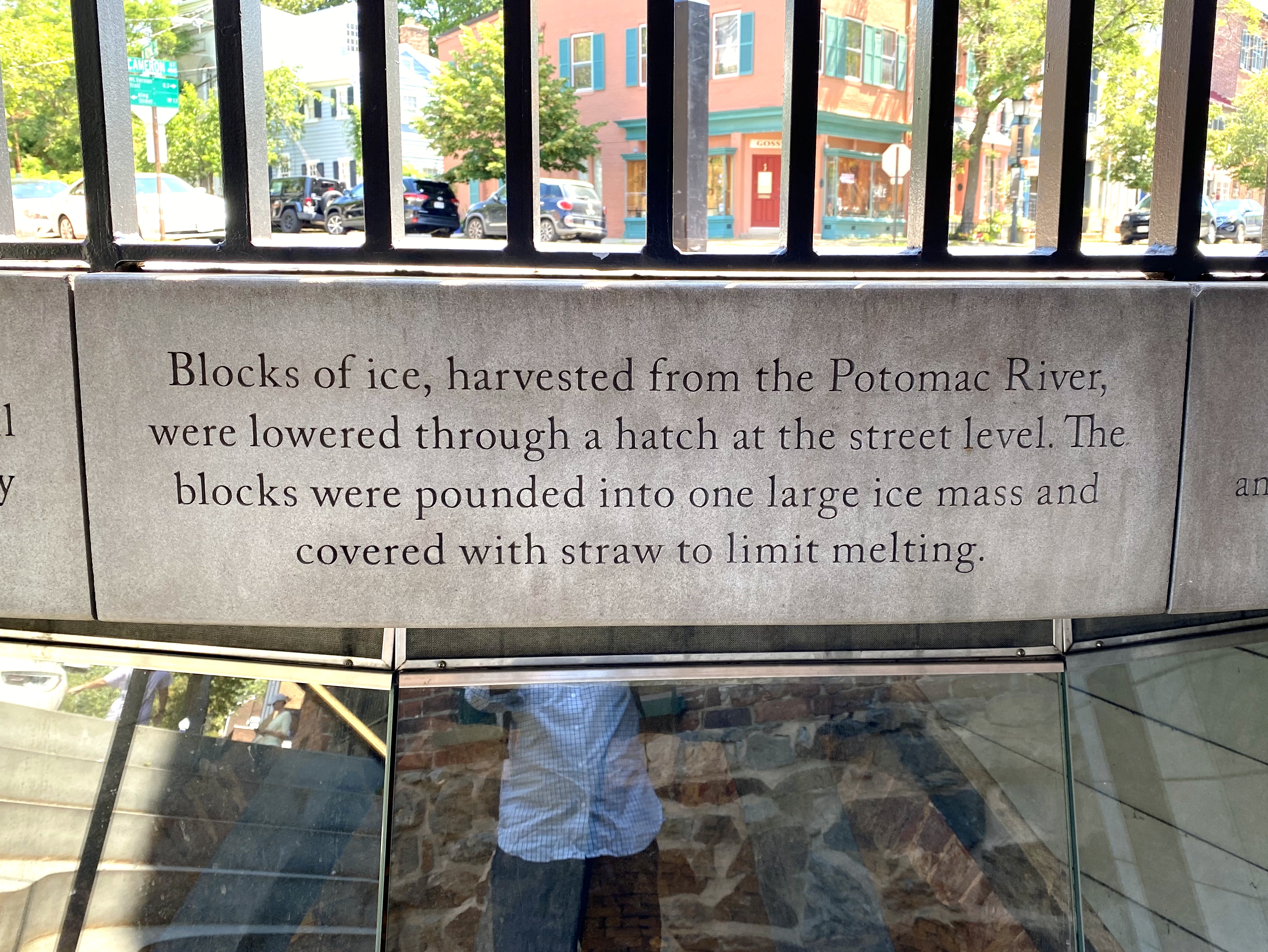
“Ice harvesting was an expensive and time-consuming process. It was cut from the frozen Potomac River in the winter and hauled by cart to the City Tavern for storage. Once in the well, the ice was formed into a solid mound and covered with straw to preserve it for use through the summer months. Preserving ice was an on-going challenge in the late 18th century and an expensive venture. Therefore, ice was generally reserved for wealthy estate owners. George Washington records in his journals the trials and tribulations of trying to preserve ice. In Alexandria, many homes had interior ice pits to store small quantities of ice. Those lucky enough to have access to ice used it to chill beverages, preserve perishable foods, and even make a new popular dessert of the day: ice cream. This availability of ice at Gadsby’s Tavern helped to distinguish the establishment as one of the finest of its kind in the 18th century.”
Linked directly to the Tavern basement by a brick-walled and vaulted tunnel, the ice well was also accessed by the tavern staff through a small hatch at street level. The City Tavern’s well is much larger than most urban residential ice wells, measuring over 17 feet in diameter and over 11 feet deep at the lowest excavation point. The well could store as much as 68 tons of ice, enough to supply the tavern and even the citizens of Alexandria. In 1805, when John Gadsby was leasing the tavern from John Wise, Gadsby advertised the sale of ice from the well, “ICE FOR SALE, Persons may be supplied with ice, at eight cents per pound on application to John Gadsby.”
A view into the ice well:
“The ice well is an important and rare example of a commercial well in an urban environment. Most ice wells have been lost to “progress” as they have succumbed to office buildings, parking lots, and housing. Examples still exist at Monticello, Montpelier, and Mount Vernon, but these were created for private and not commercial use. Gadsby’s ice well tells the larger story of commerce and the evolution of hospitality. It is a reminder to modern day travelers and residents of something we take for granted today – a ready supply of ice.”
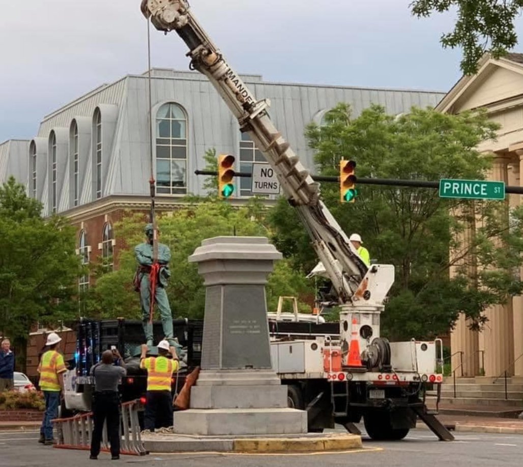
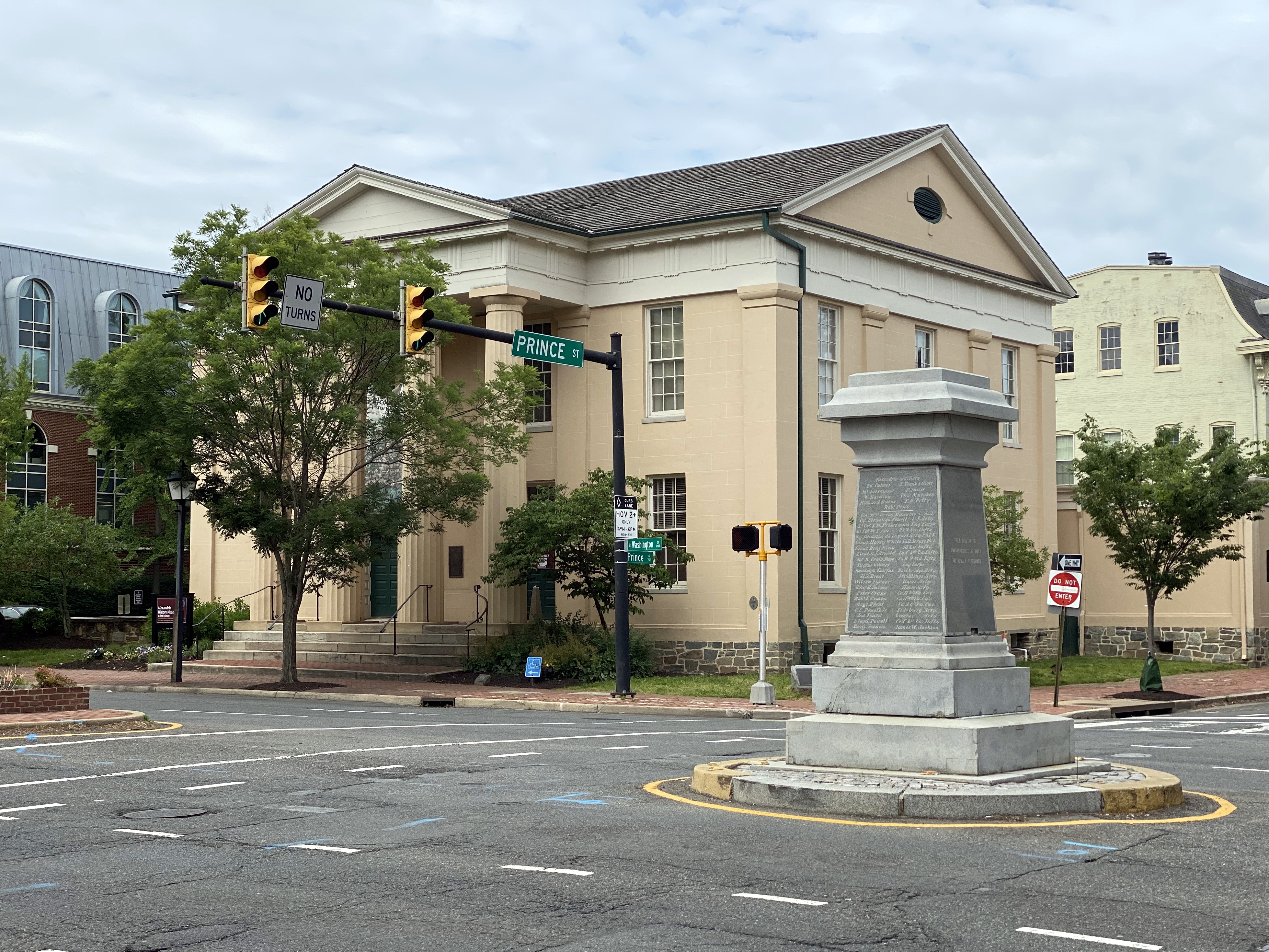
A Saturday morning quiz: spot the difference between these two pictures
We took the picture on the top a few weeks ago; we took the one on the bottom this past Tuesday.
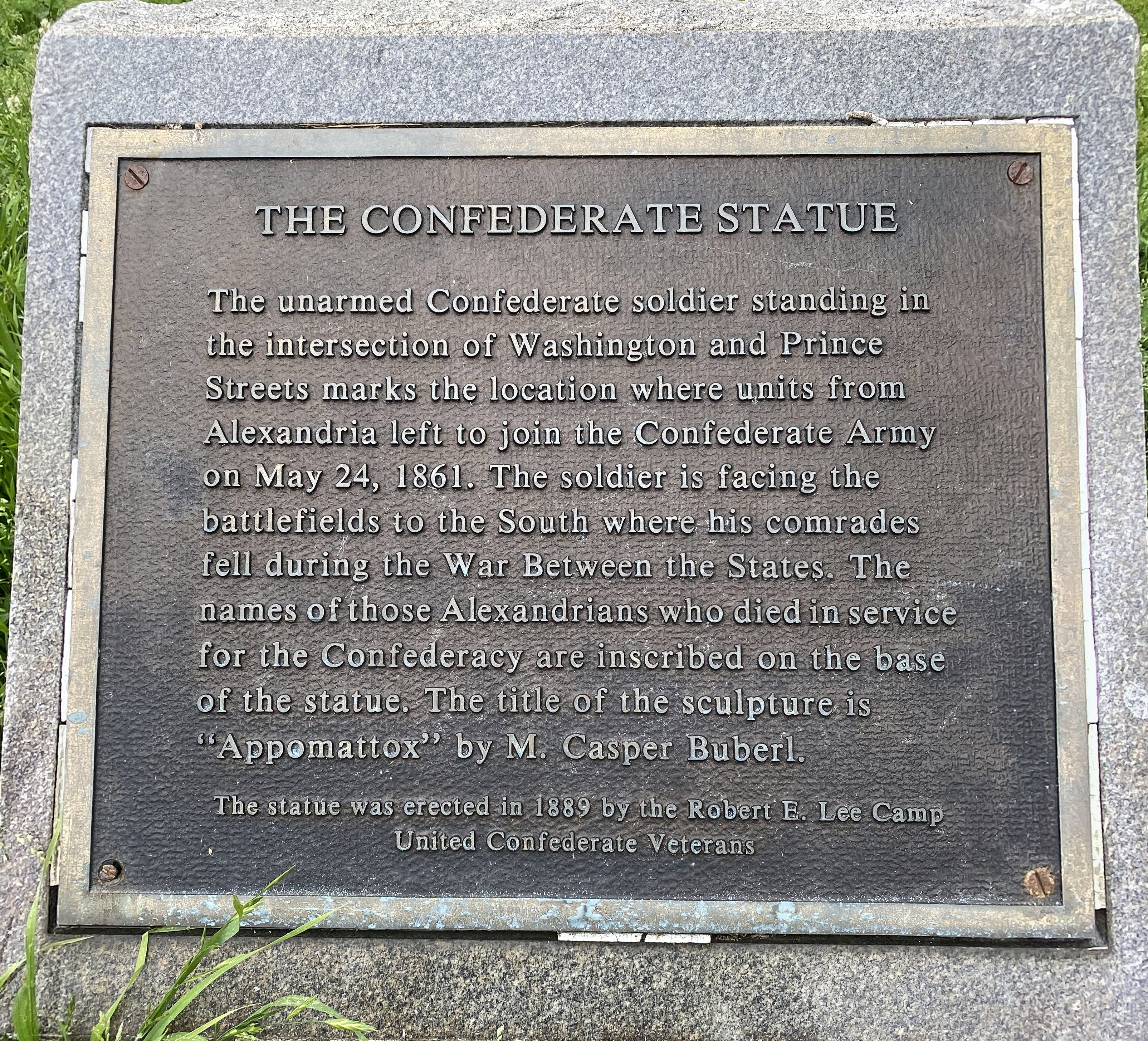
In light of the ongoing protests throughout the country, the city worked with the United Daughters of the Confederacy on Tuesday morning to remove the Appomattox statue from its plinth at the intersection of Washington and Prince Streets. The city had voted several years ago to remove the statue, but were prevented from acting on this by a state law that reserved decisions on Confederate war memorials at the state level. The new legislature that was voted into Richmond during last year’s mid-term elections reversed this policy, enabling municipalities to take the actions they saw fit. In the case of Appomattox, this required working with the monument’s owner, since the statue and plinth are not owned by the city. (The circular patch in the intersection also may be owned by the UDC – we’ve heard this, but haven’t been able to verify it. The city’s GIS parcel viewer does show a little circle at this intersection, while there is none in the other intersections, but there’s not a parcel designation for the circle.)
We previously posted on Alexandria’s Appomattox monument in 2017 after the white supremacist jackassery in Charlottesville.
From this article in the Alexandria Gazette: “Although City Council voted unanimously in 2016 to move the statue to another location, prevailing law at the time required approval from the General Assembly for the relocation of the Appomattox Statue along with other war memorials throughout the state. A bill passed by the legislature and signed by Gov. Ralph Northam (D) earlier this year removed those protections, giving authority over memorials to local jurisdictions. That law goes into effect July 1. ‘We had already coordinated with the UDC and scheduled a date for removal in July,” [Alexandria City Mayor] Wilson said. “They approached the city last night with a request to remove the statue early. That is probably a testament to the moment we are in right now.'”
A closer look:
There was earlier consideration to move Appomattox to the city’s Lyceum museum located on the southwest corner. That no longer appears to be the case and it’s unclear where the statue (and plinth, we assume) will be relocated.
Maintaining fidelity to our commitment in 2017 to avoid Europe for Christmas for a while, we spent Christmas and New Years in Southeast Asia this year. Really interesting trip! We planned to focus on Vietnam, Laos, and Cambodia (who doesn’t think of Cambodia when they think of Christmas, after all?). However, the layover location for our selected flight, as well as the arrival location, gave us opportunities to add two more countries to our list – Qatar and Thailand.
We posted our detailed itinerary in this previous article, but in summary, our trip entailed the sequence of events noted below.
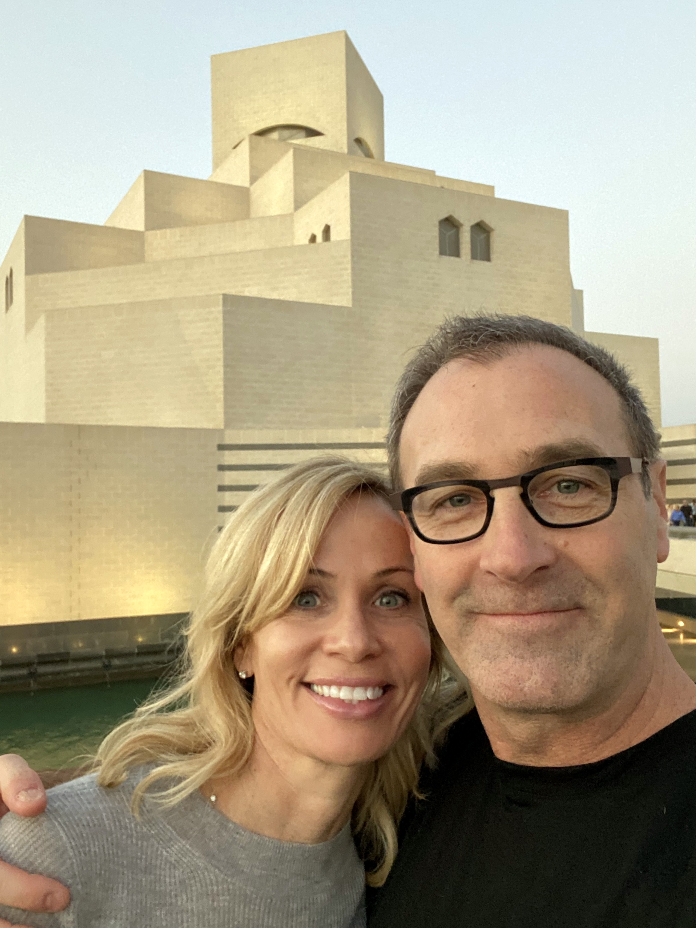
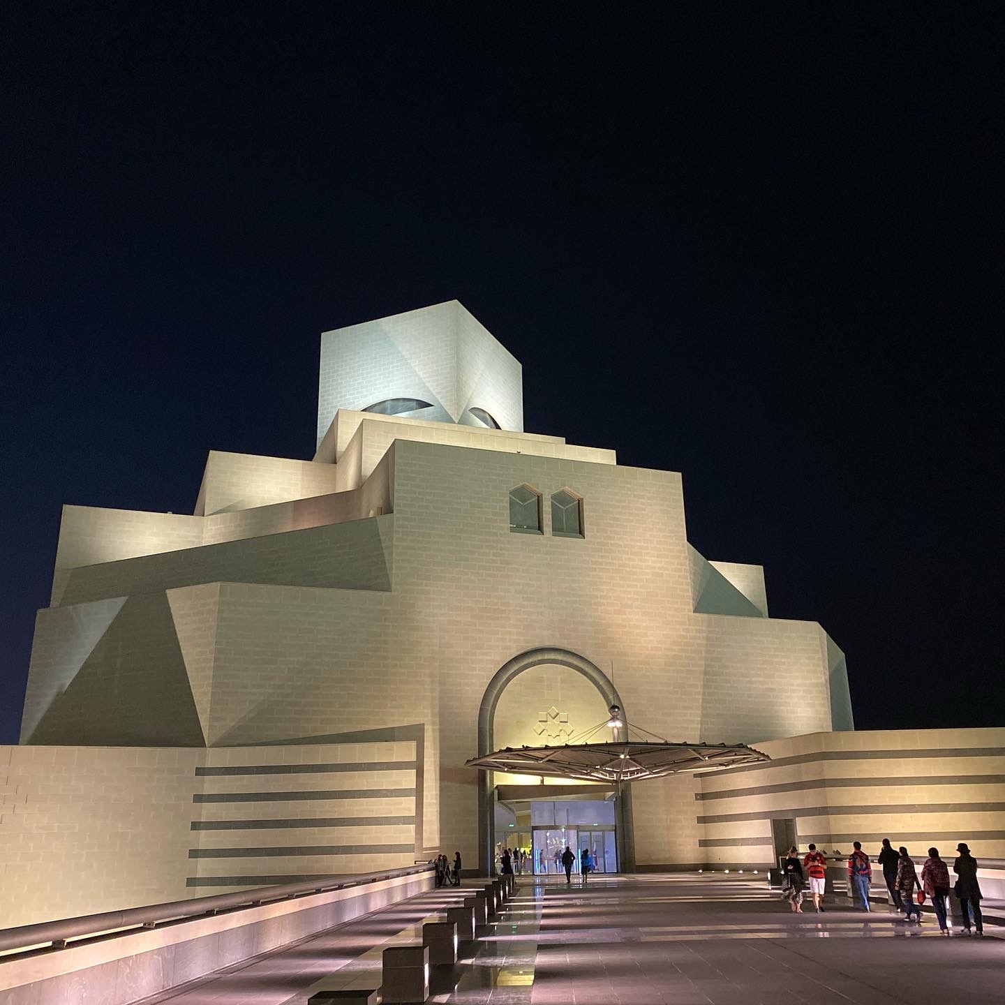
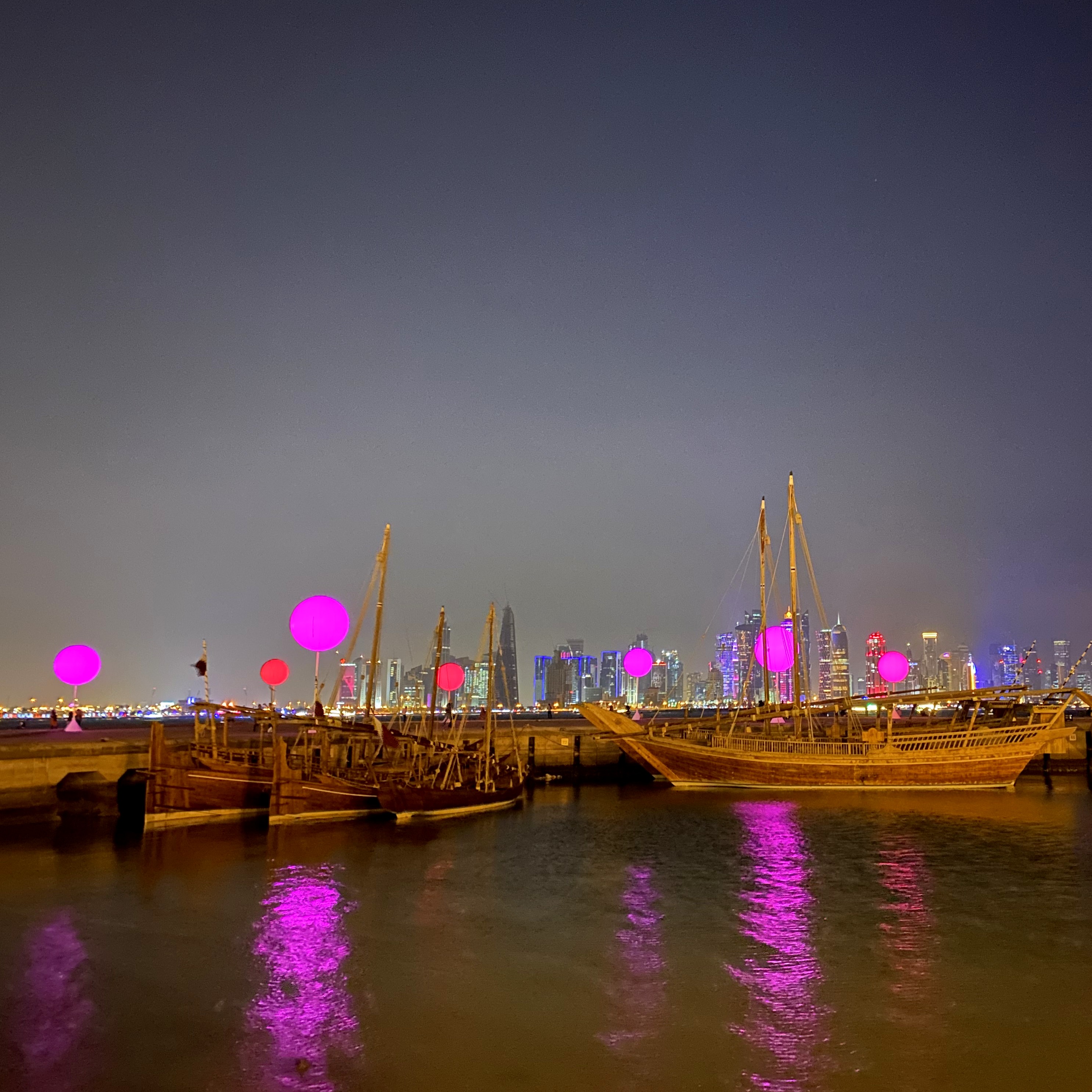
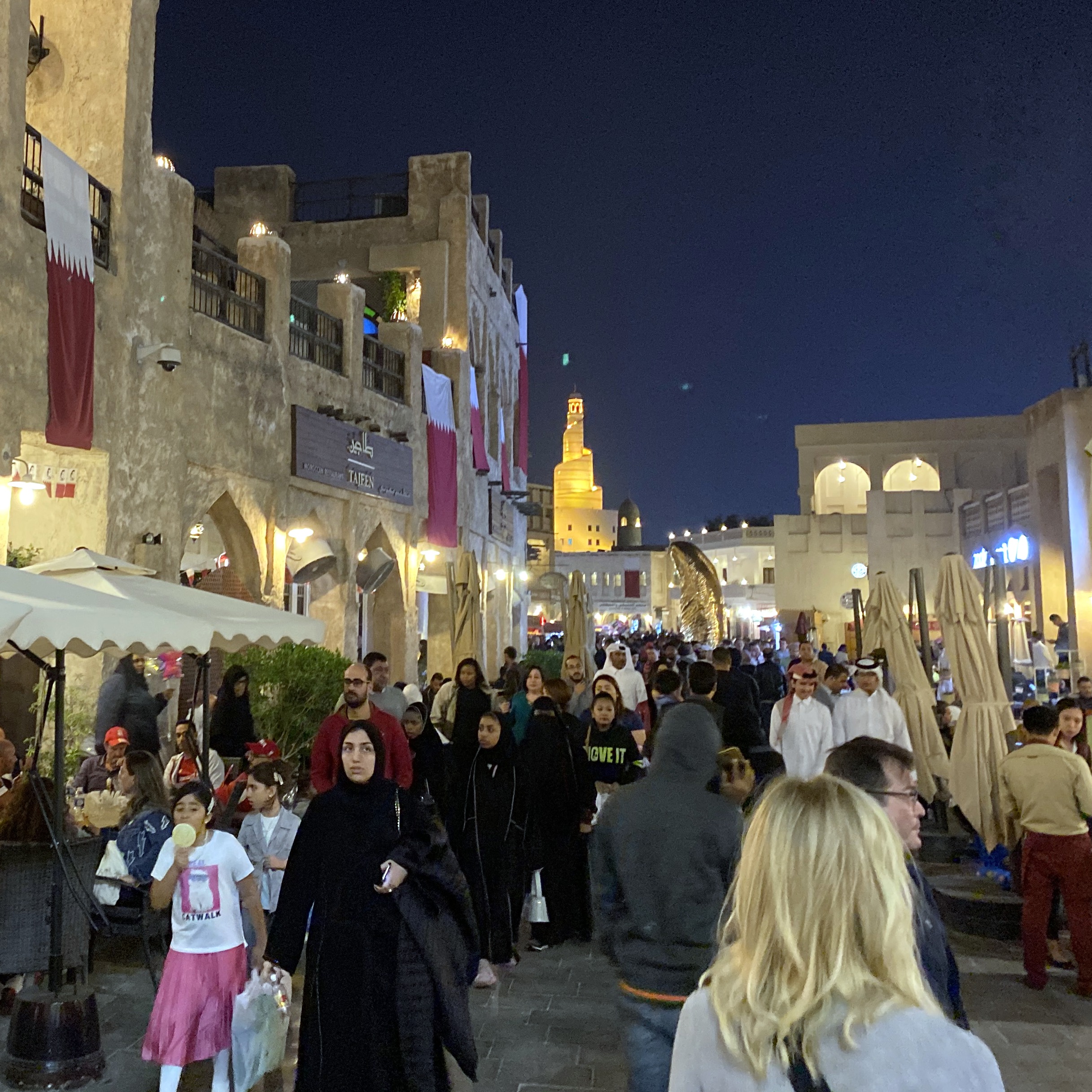
1. Take advantage of an 11-hour layover in Doha, Qatar:
Highlights in Doha included the I.M. Pei-designed Museum of Islamic Art (very cool), a long walk along the harbor corniche, and the Souk Waqif:
The real trip started when we touched down in Bangkok:
As noted in the numbered sequence in the map above, the trip went like this:
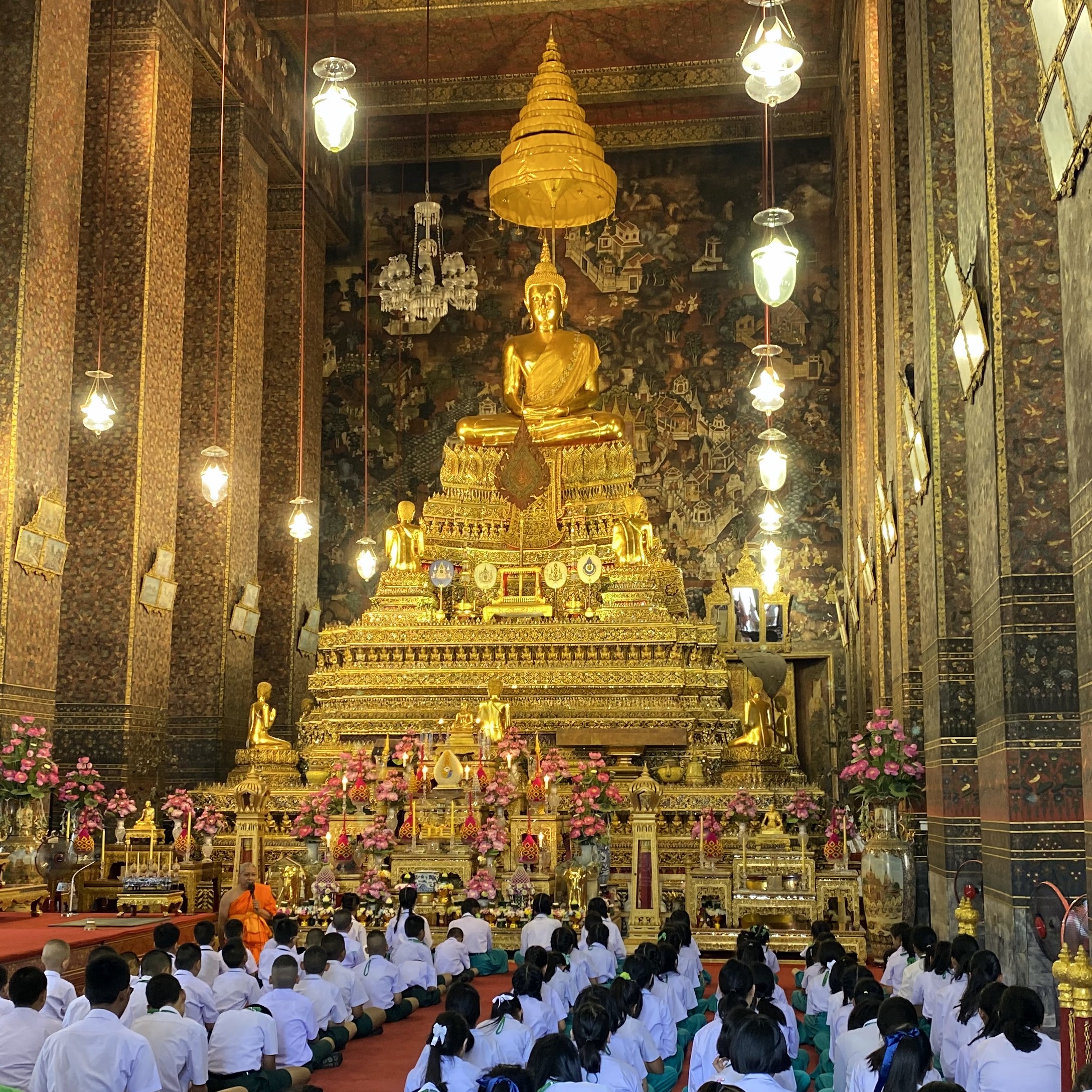
2. Arrive in Bangkok, Thailand, and spent a full day (and 2 nights) there. Bangkok wasn’t supposed to be part of the trip, per se, but simply where we’d fly into and sleep in before heading up to Laos. However, one of us screwed up in planning early on (how is this possible when a spreadsheet is involved?!) and didn’t account for an extra day we’d pick up due to the time zone change. As a result, we gained a full day to spend there, primarily at the Grand Palace and markets along the Chao Phraya River (where we finally got to eat Pad Thai in Thailand).
3. Fly to Luang Prabang, Laos, and spend 3 nights there, including Christmas Eve and Christmas Day. Highlights included mountain biking between villages in the mountains outside of town, sunset on the Mekong River, and early-morning alms-giving to the monks in a nearby village.
4. Fly to Siem Reap, Cambodia and spend 3 nights there. The major highlight was an all-day bike trip through the Angkor Wat, Angkor Thom, and Ta Prohm temples (which was an amazing way to see the temples and avoid the crowds).
5. Fly to Saigon / Ho Chi Minh City, Vietnam and spend 3 nights there, including New Years Eve. Highlights included a night time scooter ride through the city to sample street food (probably the most fun we had on the entire trip), traveling upriver to the Cu Chi tunnels used by the Viet Cong, and visiting the frozen-in-time Independence Palace – the seat of government for South Vietnam that was overrun by North Vietnam in 1975, ending the “American War.”
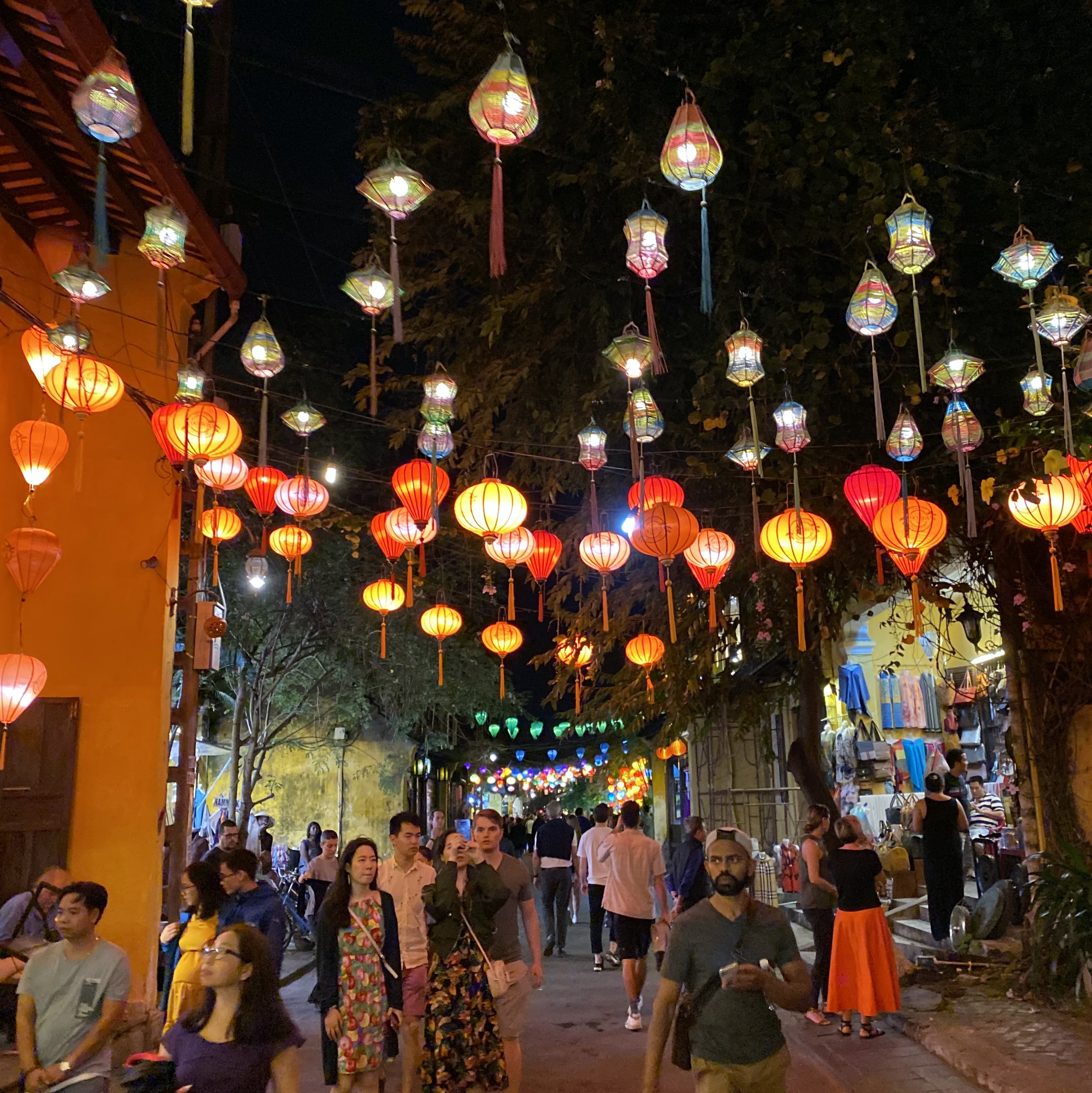
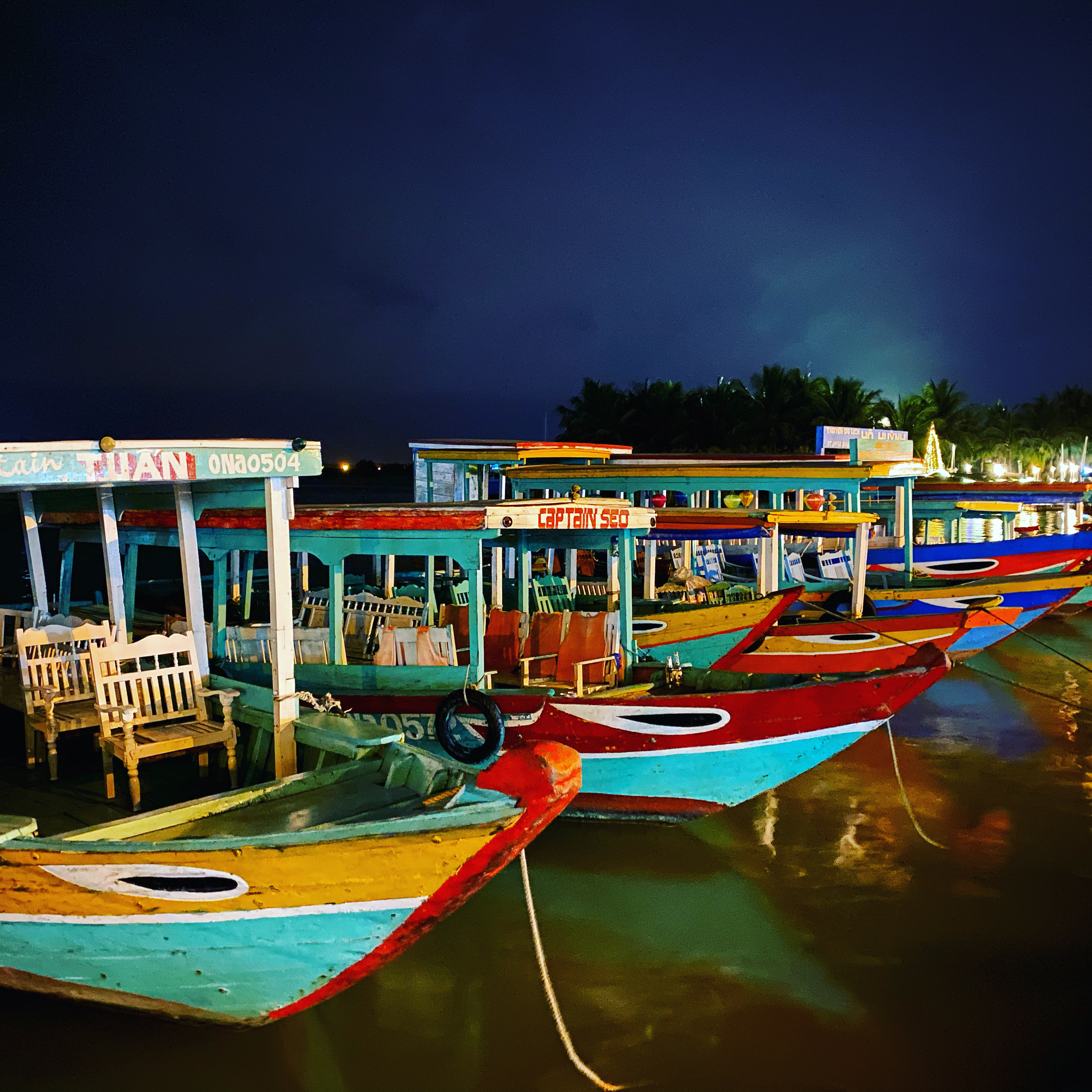
6. Fly to Hoi An, Vietnam, and spend 3 nights there. The main highlight was the ancient town itself, situated on the Thu Bon River, but this was supplemented by biking through rice paddies to the beach and a 43-dish food tasting event one morning.
7. Fly back (which entailed 23.5 hours in the air on 3 flights + 13 hours in combined layover time in Bangkok and Doha). We’re still migrating our circadian rhythms back to East Coast time, after spending 2 weeks in a time zone 12 hours ahead of Alexandria’s. The process is definitely not complete, and we’re still waking up for good each day at 4:00 AM as recently as this morning. It’s getting kind of old, at this point.
More to come on each location! (After we finish posting the remaining pics from Morocco . . .)