“WASHINGTON—A report released Wednesday by the United Nations revealed that the U.S. continues to lead the world with the highest per capita density of Kevins of any nation. ‘Ranked against the rest of the international community, the United States is far and away the global leader in Kevins, with upwards of 27 Kevins per square mile in most major American urban centers,’ said lead researcher Gilbert Dujarric, who added that when factoring in the nation’s Kevs, the density figure nearly doubles. ‘There are certainly areas of Australia, the U.K., and Canada where the concentration of Kevins is high, but they all fall well short of the United States’ Kevin population across all demographics. And when we look at the benchmark Kevin-to-John ratio, no country comes even remotely close to the staggering .205 figure the U.S. posted in 2013.’ The report’s authors noted with surprise, however, that the United States had surpassed Denmark and risen to second place in Jürgen density.”
Right on the heels of our post Five Legs in Six Weeks trip overview, the New York Times slyly attempted to one-up our juggernaut media platform with this “One House in Four Countries” article:
Clearly a knockoff of WolfeStreetTravel and a blatant brand encroachment violation, but we’ll let it pass because the situation described in the article is very cool, and certainly aligns with our interest in European history and cartography. The gist (and hook) of the article is pretty much captured in the first three paragraphs of the New York Times article:
“ ‘Wait until you find out how everyone in my family has come from a different country,’ says Alex Zigante on a recent summer afternoon.
Mr. Zigante, a 30-year-old engineer, takes a breath and lays out the family tree: His great-grandmother, Angela, was born in Austria-Hungary. His grandmother, Maria, 90, in Italy. His father, Aldo, 61, in Yugoslavia. And Alex was born and raised in Slovenia.
And yet, all of them have lived their lives here in Portorož, a seaside village in what is now southwestern Slovenia, where the family’s roots go back centuries to the Venetian Empire, and where their modest three-story home has been a fixed point on an ever-changing map.”
Even better (for WolfeStreetTravel’s interests, anyway) is the series of maps included with the article, depicting the fluid and ever-evolving geopolitical construct that swirled around Portorož over a 100-year period:
Super freakin’ cool, from our perspective, to have your property caught up in the maelstrom of pre- and post-world war political territory restructuring; then revolution; then restructuring. Absolutely enthralling.
And who doesn’t want the occasional reminder of the scope and size of the extinct but still-mildly intriguing Austro-Hungarian Empire?
The New York Times reported “Trump Suggests U.S. Territorial Expansion and Airs Grievances: In a news conference, President-elect Donald Trump refused to rule out the use of military force or economic coercion to take Greenland and the Panama Canal.”
“President-elect Donald J. Trump said (“In a rambling, hourlong news conference”) Tuesday that he would not rule out the use of military or economic coercion to force Panama to give up control of the canal America built more than a century ago and to force Denmark to sell Greenland to the United States.”
WolfeStreetTravel finds interest in all things cartographic, vexillologic, and heraldric. Particularly the compelling cartographic oddities we encounter on our travels. But yesterday, multiple news outlets (and several travel Instagram accounts we follow) reported a development directly relevant to the last item in the list.
As reported in the UK’s Guardian, “The Danish king has shocked some historians by changing the royal coat of arms to more prominently feature Greenland and the Faroe Islands – in what has also been seen as a rebuke to Donald Trump.”
The previous Danish coat of arms was formalized in 1972, but elements of the current heraldric symbols can be traced back to the rule of King Canute VI around1194. The old coat of arms did acknowledge Greenland, but subordinated its polar bear to a position in quarters within quarters upon the field (shield shape). The Greenland polar bear shared a quartered space in the lower left quadrant of the field with the Faroe Islands ram, below three crowns, “symbolizing “the symbol of the Kalmar Union between Denmark, Norway, and Sweden, which was led by Denmark between 1397 and 1523.”
Denmark’s new coat of arms more prominently devotes an entire quarter of the field – the same lower left quadrant – to the polar bear symbol of Greenland. Although not as relevant to the story, the Faroe Islands’ ram gets its own quarter a the top right quadrant of the field, and the crowns are now gone. (They made cosmetic updates to the dudes with the clubs, too, but no one is commenting on the rationale for this change.)
All of this, of course, in response to Trump’s declaration that owning Greenland is in America’s strategic interest. Trump wrote yesterday on Truth Social, ““Greenland is an incredible place, and the people will benefit tremendously if, and when, it becomes part of our Nation. We will protect it, and cherish it, from a very vicious outside World.”
The Washington Post reported that “For the Danish government, this situation is “a huge headache,” according to Mikkel Runge Olesen, senior researcher at the Danish Institute for International Studies. “It cannot be seen to be pressuring Greenland or jeopardize relations with Washington, which it depends on for security guarantees through NATO.”
Headache or not, WolfeStreetTravel finds it fascinating that the Danes are asserting their sovereignty over Greenland through updates to their ancient heraldric symbols while this whole thing plays out in the lead up to the new presidential administration.
As Russia continues their belligerent posturing along the Ukraine eastern border (and now on Ukraine’s northern border with Belorussia, where Putin has begun positioning even more troops), it’s helpful to understand the history of Ukraine’s borders in the political and cultural fluidity that characterizes central Europe. (Let’s be serious – fluidity across all of Europe, which is why the place is so freaking interesting from a historical and cartographic perspective.)
Our buddy, Jim, who also follows WolfeStreetTravel, recently recommended this really compelling Washington Post article from 2015 on the evolution of Ukraine’s territory and borders. This article was published when Putin was previously taking aggressive actions to absorb Ukraine’s Crimean Peninsula into mother Russia. Definitely recommended reading for anyone following the crisis unfolding around Ukraine.
The Washington Post’s resident cartographer, Gene Thorp, developed for the article several really helpful and really compelling maps depicting how Ukraine’s territory transformed over the centuries as empires, warring factions, and treaty agreements changed. To wit:
Catherine the Great’s encroachment into what previously was either sovereign Ukrainian territory or land ruled by the Polish-Lithuanian Commonwealth in the 17th century. (WolfeStreetTravel previously included latter in another Mappy Hour post on the evolution of Europe during the Brexit buildup.)
Or, a severed Ukraine after the post-WW I Treaty of Brest-Litovsk, where Poland wound up with most of western Ukraine, including the major city of Lviv, but lost the territory during the Russian civil war, after which Ukraine joined the USSR as the Ukrainian Soviet Socialist Republic within the union.
The body of the article includes more maps and some really great context for how and why Ukraine looked like it did at different times during the last 1000+ years, as well as how the native people of Ukraine changed due to Soviet actions. Good stuff!
With the widespread availability of COVID vaccines in the US starting in April and the dramatic and steady increase in vaccinations by June, we were feeling bullish once again about travel this summer. Most importantly, about resurrecting our ill-fated South of France road trip planned for Labor Day 2020. This discarded trip was sadly documented in the last “trip planning and itineraries” post here, as well as on our subsequent post on the consolation to the consolation prize that took its place. Last year sucked.
So, this past June – full of vaccinated confidence and excitement – we booked three sets of flights to reassert our road trip through Languedoc, Provence, and beyond.
Then, of course:
The f’ing Delta variant is screwing everything up.
So, here’s where things stand as of this morning:
France has opened their borders to Americans if you’re vaccinated. No worries here. We are, so we’re good.
We have a non-stop, round-trip flight on United from Dulles to Paris on Friday evening, August 27. We can upload images of our vaccination cards to United to meet the French entry requirement above, so, no worries – we’re still good there.
We have a separately booked, one-way flight on Air France from Paris to Montpellier. Air France requires passengers to have the French passe sanitaire (health pass) to board. This is a QR code that gets screened in order to enter restaurants, museums, flights, etc. We do not have this. So, some worries – we’re not good here.
But! France announced on August 9 that a new program has been established to issue health passes to non-EU travelers to France if you submit a completed application, photo of vaccination card, photo of passport, and photo of plane reservations. We did so on August 11.
It’s now August 22 and we have not received anything. We still have time, but, as is attested by the previously planning posts, we (one of us, anyway) like all variables to be locked down before we travel. As a result, we’re consumed with this lack of a health pass. There’s a real possibility that we’ll get to Paris and not be able to board our internal flight south.
But all is not lost. The French government website for the health pass program for non-EU residents was updated this past Thursday to clarify that they’re only processing applications for travelers currently in the country or who will be arriving by today. Hopefully, the next processing window will include August 28.
In addition to potentially receiving French health passes in the next few days, we have the following backup plans:
Take COVID tests 2 days before we leave, like we did for Turks and Aruba, and present the negative tests to a health care professional at Paris CDG airport to get health pass QR codes.
Take COVID rapid antigen tests in the airport itself after landing in Paris to accomplish the same. These are available at CDG in the public area, so even if we don’t have tickets yet, we could access this. We have a 6-hour layover there because the only direct flight from Paris to Montpellier was in the early afternoon, so would be able to swing this, timewise.
Present our vaccination cards to board instead of a QR pass and hope for the best. This has worked at restaurants and other venues, based on research on the interwebs, but not always. And the Air France web site cites the requirement for the passe sanitaire, not just proof of vaccination.
We like Option 2 and will likely exercise this if we don’t get a QR code before we leave. However, the ones you get from proof of a negative test are only valid for 72 hours, which would mean repeating the process every 3 days while we’re there. Def would rather get the permanent one now . . .
So, the trip. In brief, we’ll:
Rent a car in Montpellier, on the Mediterranean coast, and drive all over the place in both the Languedoc and Provence regions of the South of France, a la the epic Micronations Road Trip,
End up on the Atlantic coast in San Sebastian, Spain, for a few days,
Drop the car off across the French border in Biaritz to avoid an even more mammoth drop fee than we’re already facing simply by dropping it at another location in the same country,
Fly back to Paris, then fly back home.
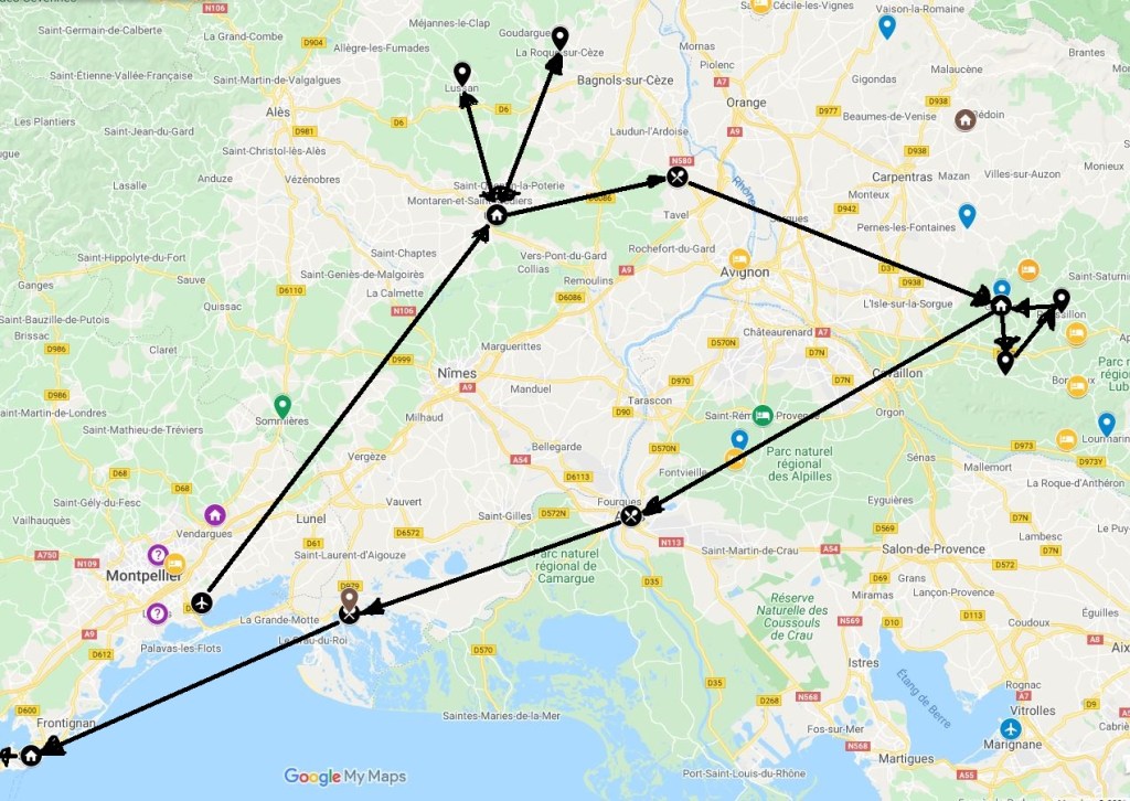
As explained in our previous trip planning post, Google My Maps served a pivotal function in planning (and then replanning) this trip. The result was this useful mess:
The previous post explained the the pin colors and icons used on the map. The end result, though, is the distilled-down itinerary for this here trip, which is represented by the black pins. If we blow up the South of France portion of the map, we can see these icons more clearly:
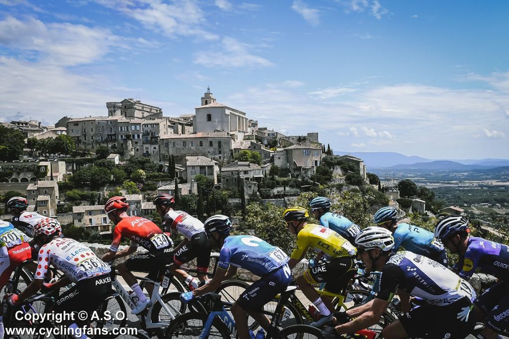
The little houses are towns we’re staying in (Uzes for 4 nights, Gordes for 3 nights, Sete for 2 nights, in that order). The plain black pins are other Les Plus Beaux Villages de France (“the most beautiful villages of France”) that we’ll day trip to from our base towns. If you watched the Tour de France this year, btw, you would have seen the peloton ride through both Uzes (Stage 12) and Gordes (Stage 11).
The little knife and fork guys are stopovers on the longer trips between base towns.
We chose to stay in Sete (extreme lower left) for a couple of days simply because one of us thought that, if we’re so freakin’ close to the Mediterranean, then we should at least spend some time there. So we are.
From Sete, we head northwest to Toulouse for the night (we booked this totally cool castle turret in the middle of town on Air B&B only to have this unceremoniously cancelled on us without explanation a couple of weeks later). We still haven’t booked a replacement; since the stop in Toulouse is just to break up a 7-hour drive from Sete, France, to San Sebastian, Spain, and because there don’t appear to be any particularly charming places to lock in (other than our ill-fated castle turret), we’ll just deal with this when we’re over there.
From Toulouse, we’ll drive the same distance as the day before, but to the southwest, to San Sebastian, just over the border in the Basque region of Spain. We’ll spend 4 days there – the center of gravity of the world’s gastronomic dining scene, where there’s higher density of Michelin-starred restaurants than anywhere else on Earth. There’s also pintxo, which holds an equal appeal for us.
An interactive version of the full itinerary-planning map is here:
To get back home, we’ll have to find another COVID testing station in Spain to secure the required negative test results to reenter the US. We assume that won’t be a problem, but then, there’s this recent article in the New York Times: “Blindsided Abroad: Vaccinated but Testing Positive on a Trip to Europe,” with anecdotes of travelers in our situation having to quarantine due to a positive result from a test taken to get back to the US.
Definitely some risks, but definitely still worth it. We’re looking forward to busting out of here.
A post this morning decidedly not about travel. Instead, a wildly entertaining one on words, albeit not one of our creation. In addition to our well-established reputation as cartography geeks (and our lesser-known, but related, verve for vexillology), we’re also word nerds. (For any in doubt, we would simply point to this finely curated collection here.)
“Opinion: How I wound up with a wound from heteronyms”
“The English language has something to confuse or annoy just about anyone — the mysteries of who and whom usage, the e.g. vs. i.e. standoff, the polarizing Oxford comma. I have a long-standing, personal problem with heteronyms — words that are spelled the same but don’t sound alike. Allow me to explain with a little story.
In order to graduate from the graduate program at my university, every student was required to take part in a group discussion of heteronyms. My group asked me to take the lead which, alas, went over like a lead balloon.
I now know that when trying to perfect one’s thinking for the perfect presentation on heteronyms, you must project confidence in your project and be content with the content. I was not.
Shy by nature, I do not live to give live presentations. Nor am I very articulate, so it’s always been difficult for me to articulate my points.
The teacher, as if able to intimate my most intimate fears, knew this. Like a food fighter at a buffet, he immediately began to buffet me with criticisms. He raised minute points every minute. I made a futile attempt to object to being made the object of his ridicule. I told the teacher his conduct was unacceptable and this was no way to conduct a class. He told me my arguments were invalid and I was being an emotional invalid.
As he continued to tear into me, I shed a tear.
I’m normally reluctant to attribute a negative attribute to anyone, but as I wicked away the moisture on my cheek with a tissue, I decided my teacher was a wicked man. There is no good excuse to excuse cruelty.
Meanwhile, the class took sides, and a row broke out in the back row.
Sensing I was sailing against the wind, I tried to wind up my presentation as quickly as possible.
Afterward, some classmates and I made a deliberate plan to meet so we could deliberate on what went wrong. They agreed that my big mistake was to just stand in front of the class and read what I had read. Technically, it isn’t plagiarism, but it also isn’t appropriate to appropriate others’ work.
They also agreed that my opening was poor, arguing I should have used my entrance to entrance my audience.
As this record indicates, and as history will record, my interest in heteronyms continues. But thanks to that cruel teacher, I wound up with a wound that remains to this day.”
As noted in the Post: “John Ficarra was the editor of Mad magazine from 1985 to 2018.” Indeed.
As anyone who follows this blog knows, we’re weirdly enthralled with all things cartographic in Europe. Plus, we have a comparable passion for Old Town Alexandria – the undisputed best small town in America – which includes our fair city’s retrocession from the District of Columbia in the 19th century. A local cartographic legacy that is still represented by extant boundary stones in Virginia delineating the original borders of the District.
Imagine our nerdy elation upon reading a news article in today’s New York Times that involves both!
Regarding boundary stones, recall this image from our Alexandria, DC, post celebrating the anniversary of our fair city’s retrocession:
Boundary stone Southwest 2 near Alexandria’s Union Station
Now, compare that image with this one of the 1819 boundary stone on the Franco-Belgian border from this morning’s article:
You can read the full New York Times article here, but the essence is captured by this paragraph:
“Apparently frustrated by a 200-year-old stone border marker, a Belgian farmer dug it out and moved it about seven feet into French territory, local officials told French news media, thus slightly enlarging his own land as well as the entire country of Belgium.”
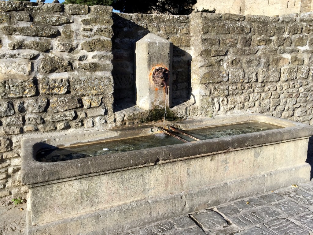
Can fountains be considered couth or uncouth? Maybe? Whatever. The ones that we’ve encountered are both cool and compelling, if not couth (and WolfeStreetTravel always likes a pun, no matter how tortured it may be).
One of the common denominators to travel in Europe is the ubiquity of cool and compelling public fountains. Not decorative fountains serving as atmospheric – but nonfunctional – water features, like Trevi Fountain. We’re talking about fountains that serve as public drinking water sources in city and village squares all over the continent. We find them weirdly appealing and compelling (and sometimes gratifying, as was the case in the heat of the Southern Italy summer while biking through parched Puglia).
Because we don’t anticipate getting back into Europe for the next 6 months or more, we figured this would be a logical time to finally post the collection of cool-ass fountains that we’ve been aggregating by theme for several years into a single post. Again, weirdly appealing to us, with an emphasis on weird. What more can we say? So, we’re taking a quick break from posting on the Southeast Asia trip to finally put this one up on the site.
Thematically, you first got your stern- and angry-looking dude-with-additional-features-style public water fountains:
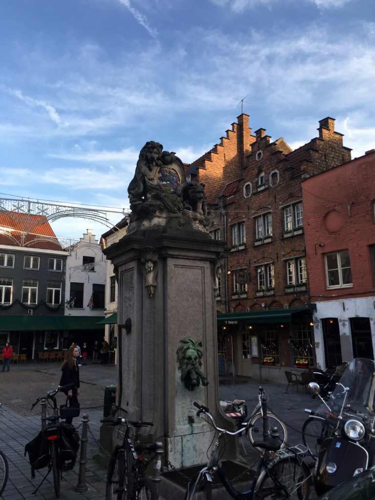
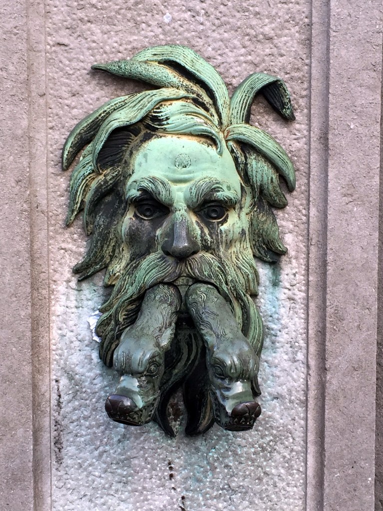
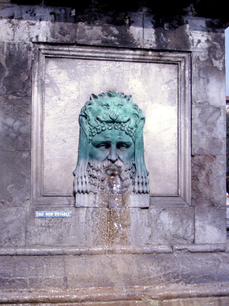
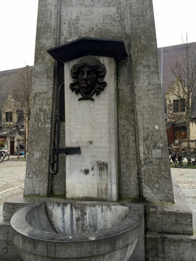
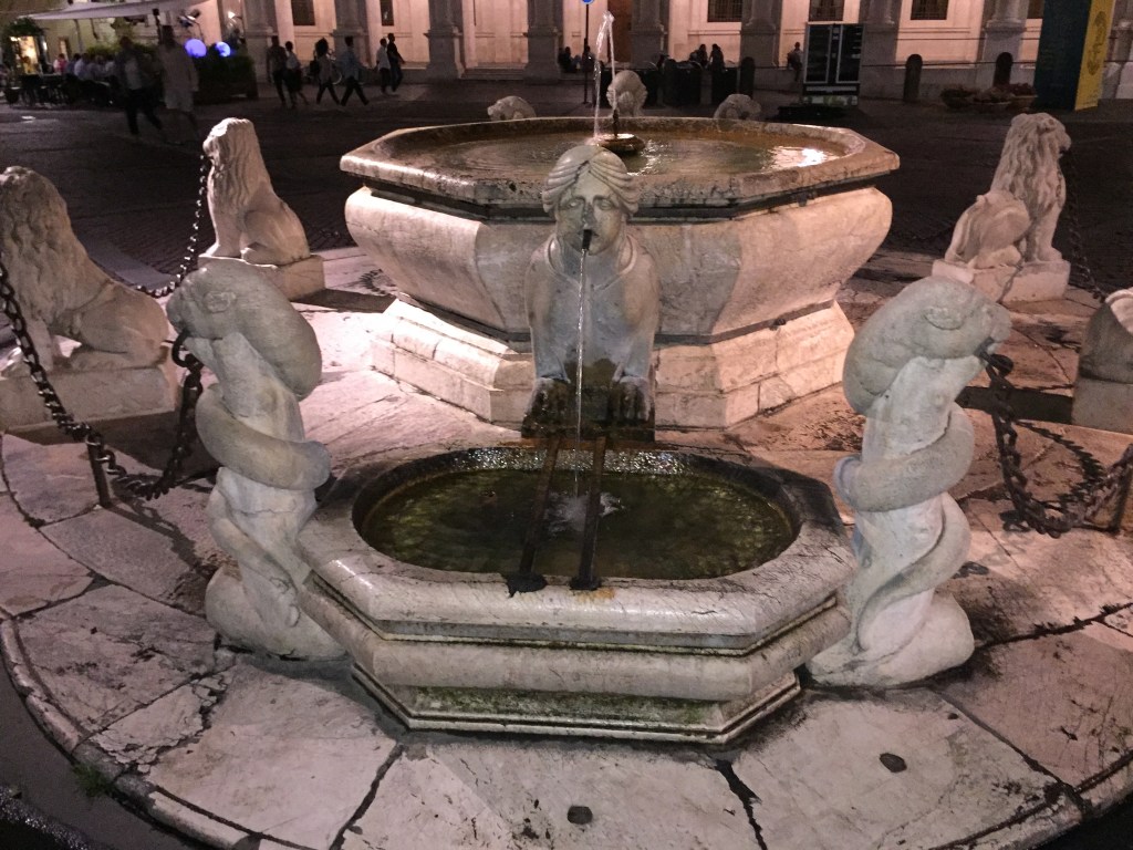
Cool fountain in Bruges, Belgium, from a Christmas trip in 2015.A disembodied head in Ljubljana, Slovenia, from a 2008 trip.An absolutely furious water dispenser in Belagio, Italy, in 2004.A withered, disembodied head fountain in Split, Croatia, from 2008. What a delight to have your drinking water dispensed by this guy. . .Dude at the Netherbow Wellhead in Edinburgh, ScotlandA brass, satyr-looking dude dispensing drinking water inside the Hamburg Rathaus from a Christmas trip in 2017.Our favorite fountain in the town square / Roman forum in the middle of Arles, Provence, France, from our trip to Europe in 2002 and our first bike trip, at that.
Closeup of the fountain face. This has become our avatar for WolfeStreetTravel for two reason: 1. It’s cool as shit and very Gaulish / Celtic 2. It’s an iconic image from our very first European trip
(We’ll acknowledge that this one isn’t actually a drinking water fountain, per se, considering the non-potable sign, but it’s absolutely included due to the reasons noted above.)
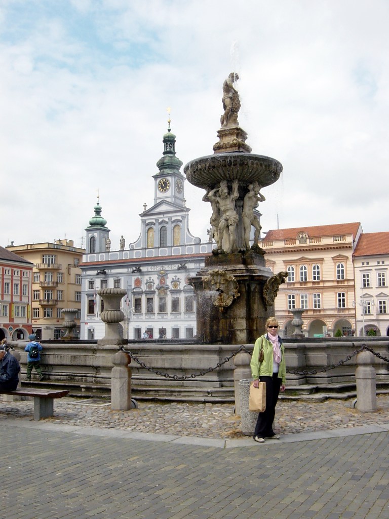
Cherubimic little fella in Dubrovnik, Croatia, in 2008.Cool fountain in Beaucaire, Provence, France, in 2002.Scallop-headed dude with fish from London in 2016.Hulking Samson’s fountain (Samsonova Kašna) in České Budějovice, Czech Republic, built in the 1720s. From a Central European bike and road trip in 2006. České Budějovice, btw, is hope to the original Budweiser beer, the source of legal battles over the decades.So, maybe this one isn’t actually a drinking water fountain . . .
Interesting iron fountain in Kotor, Montenegro, in 2008. Very cool fountain in Stockholm, Sweden, in 2016.A very similar, but smaller one in a different media, in Paris in 2008.
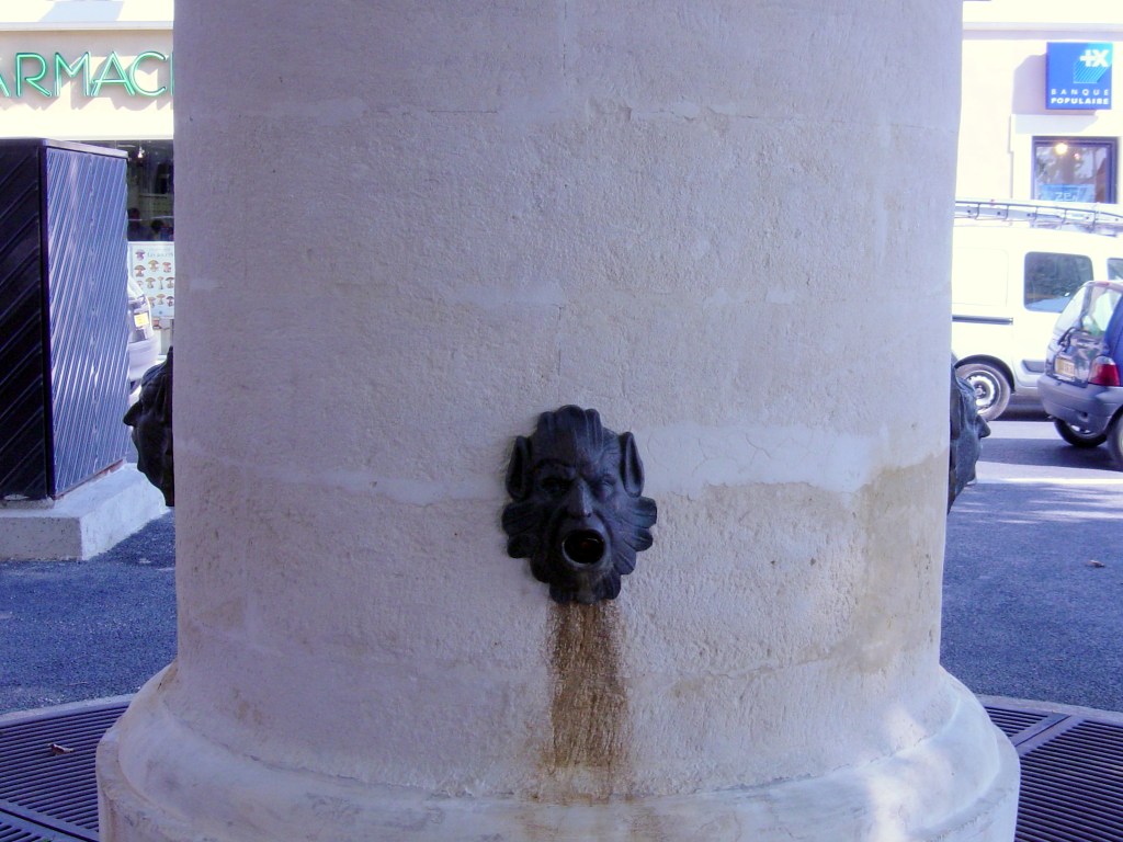
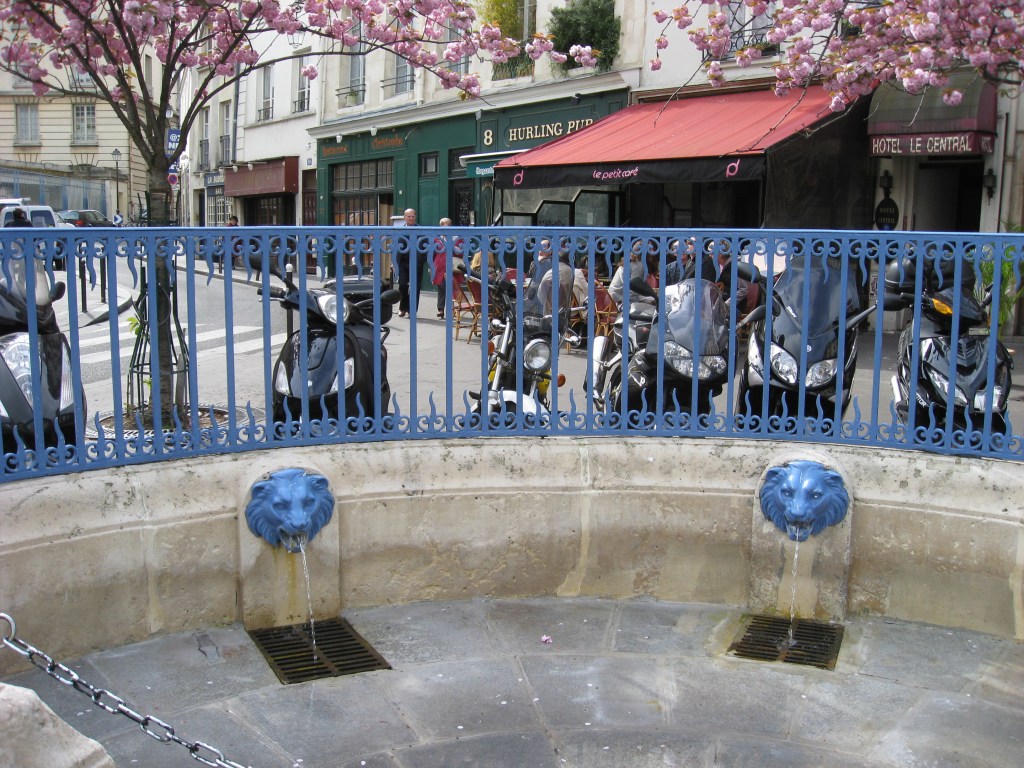
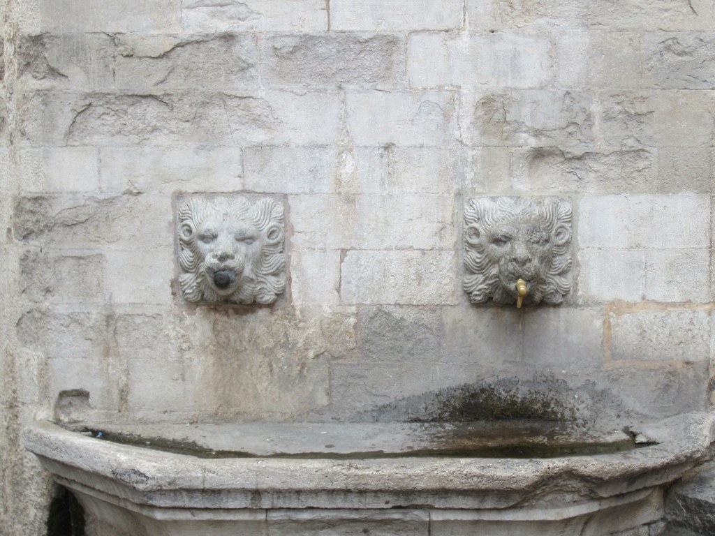
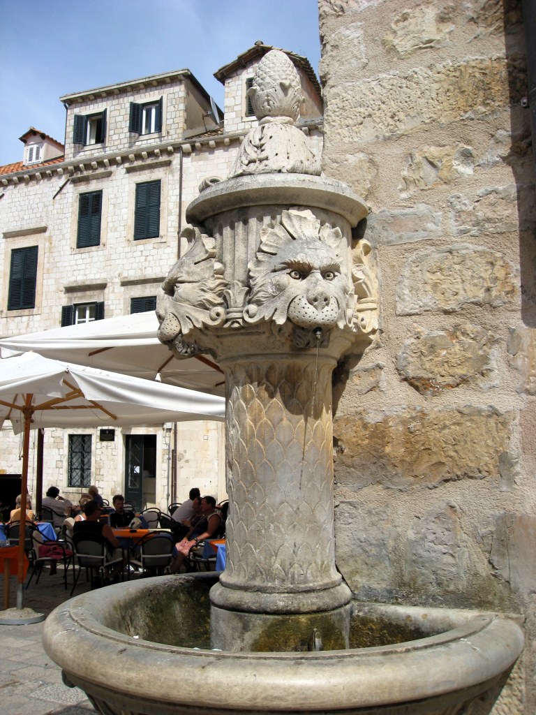
You got your always-popular lion fountains:
Located just down the street during the same trip to Paris, but in an adjoining arrondissement, are these stylish, royal blue lions.Paris, FranceA sad, confused, or constipated lion fountain in Dubrovnik, Croatia, from 2008.A lion fountain supplying a watering trough right outside the walled city gates in Carcassonne, France, on a stopover during the Great Micronations Road Trip of 2017.A pair o’ lions in Girona, Spain, the starting point for our bike trip through Catalonia in 2011.
And, your lion / creature hybrid?
Another fountain in Dubrovnik, Croatia, from 2008.
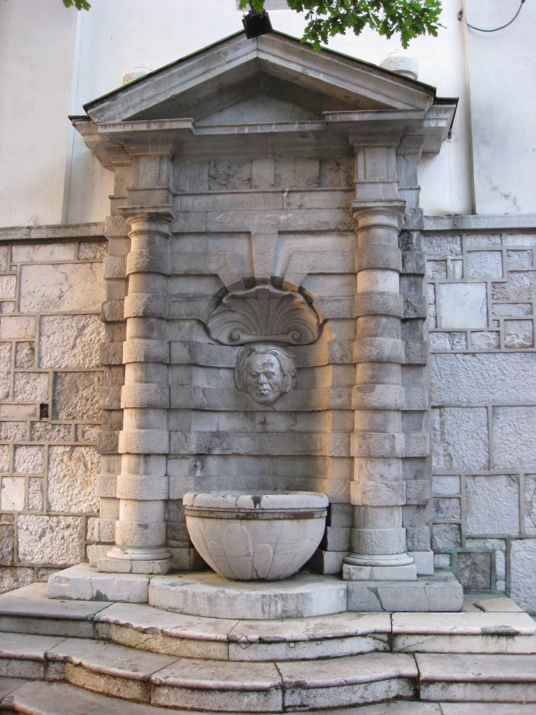
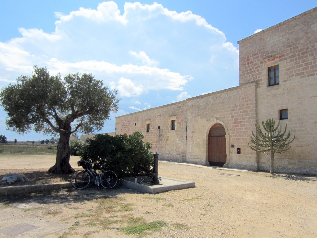
Finally, you got your truly utilitarian water fountains out in the country – in this case on rides in Italy and Spain.
Countryside fountain located while biking in Puglia – as long as it had a brass spout, it was potable, and the water from all of these was excellentOutside the village of Colmers in Catalonia while biking in 2011 (took this ’cause of the snails, not the design . . .).A perfectly located fountain at a masseria along one of our rides in Puglia in 2013.A formerly functional and now purely decorative fountain in Strasbourg, France, during Christmas 2017.
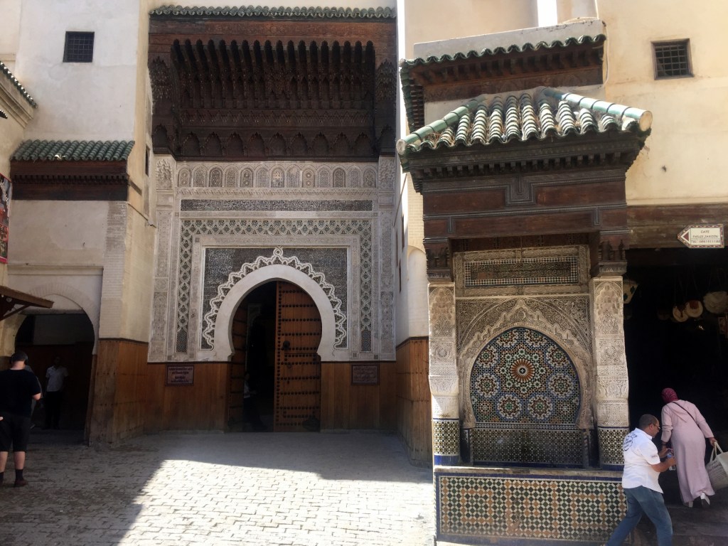
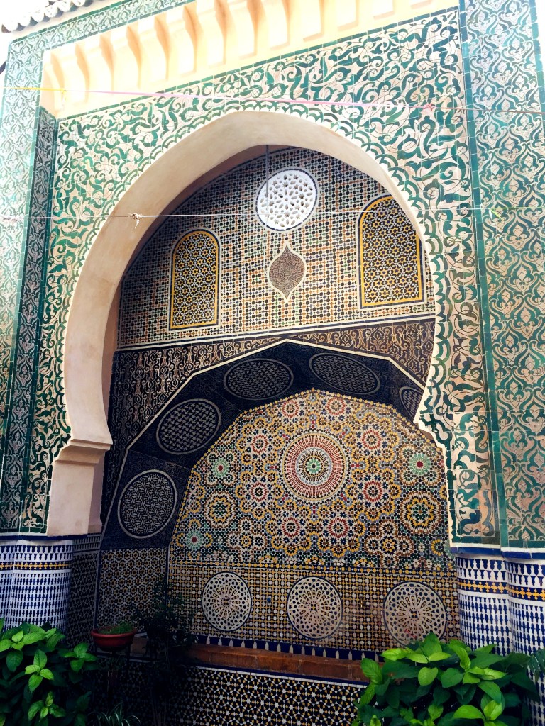
And now for something completely different: Moroccan public water fountains. We thought we’d expand the theme of awesome European water fountain sculptures to the same function, but different approach, in Morocco, home to the “I shipped my pants” advertising campaign. Here, the public water fountains are all about the mosaic tile.
Potable water fountain outside Fez‘ Museum of Wood in 2019. Yup. Museum of Wood.Another fountain in full use deep within Fez’ medina in 2019.
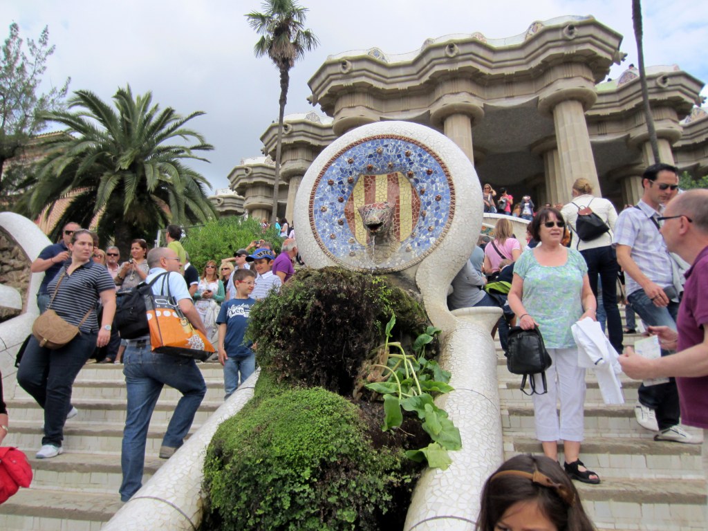
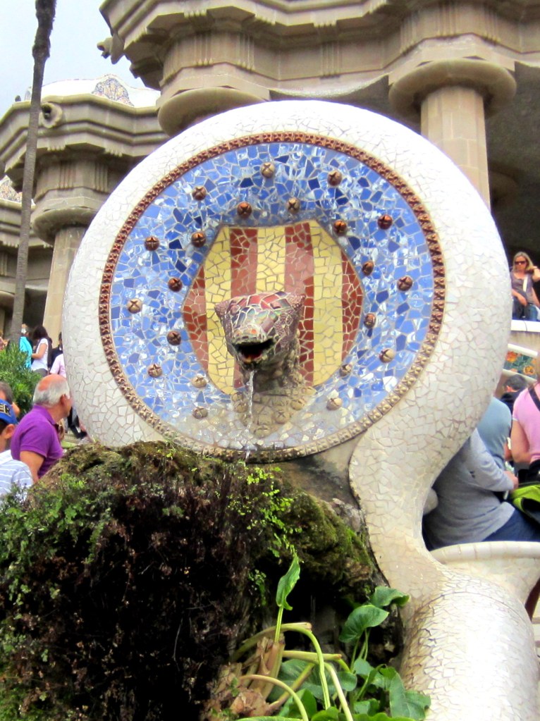
Further expanding the theme, here’s a couple of NON-potable water fountains, deviating from our original theme to a few decorative fountains. That are cool enough to qualify for the post: Antoni Gaudi’s tiled animal fountains, unique to Barcelona’s Parc Güell.
And finally, a further expansion to the drinking fountain theme – a stretch beyond which we really can’t expand further without diluting the original theme to oblivion.
Town cistern and multifaceted fountains down the street in Dubrovnik, Croatia, in 2008.Another in an unmarked, tiny town in Catalonia, Spain, while biking in 2011.
And finally, a contribution from home: the weirdest freakin’ fountain-type sculpture in the DC metro area, as far as we’re concerned:
There are a series of these creepy fish dudes along Ohio Drive Bridge downtown, otherwise known as the Tidal Basin Bridge:
What the hell? Not only does the dude have a fish body, but he’s definitely leering.
We’ve never known what they were, but whenever we bike or walk over this bridge, we’re always weirded out by them. Other than that awareness, though, we didn’t know anything else. But in posting this, we did find a Washington Post article that explains these, and why the dude’s a fish. “The bronze sculptures on the Ohio Drive SW bridge at the Tidal Basin were commissioned about 1987 in honor of Jack Fish’s forthcoming retirement from the Park Service. They are more correctly called grotesques, because they don’t have the rainspout that defines a gargoyle.” Jack Fish was director of the National Park Service’s National Capital Region until 1988.
So, they’re technically not the European city square drinking water fountains that we’re enamored with, but they’re thematically similar enough to include here.
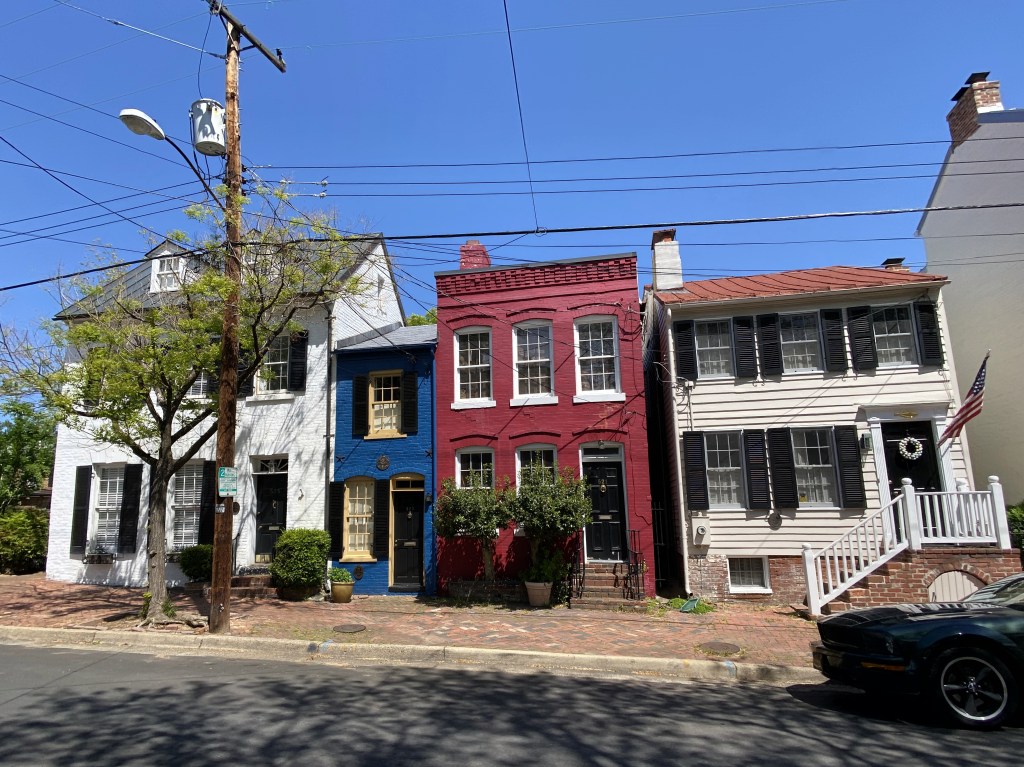
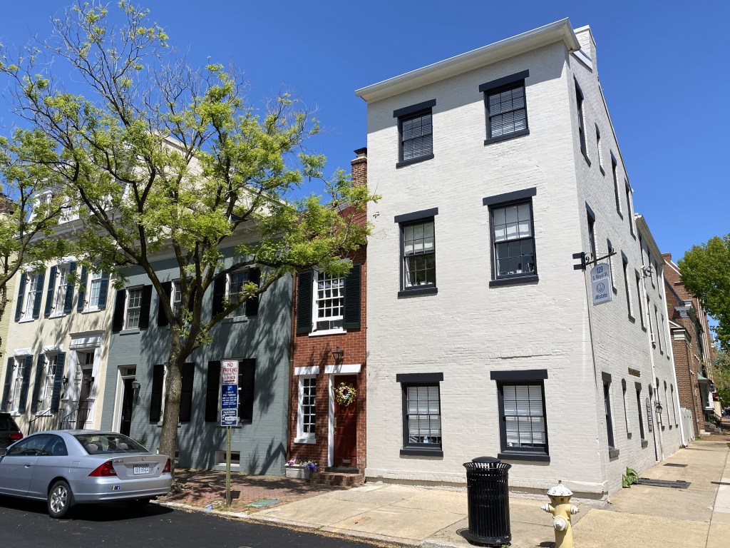
The narrowest house in Old Town (and reportedly the narrowest house in the country) is located on the 500 block of Queen Street and is known as the Spite House. It gets way too much attention, given a relatively unknown competitor three blocks away from us on Prince. (Nonetheless, it made it into one of our previous posts . . .)
The place even rated a story in the New York Times, from which we’ve quoted its origins: “The house, 7 feet wide, about 25 feet deep and a whopping 325 square feet in two stories, is a tiny landmark on Queen Street in the Old Town district in Alexandria, Va., just across the Potomac from Washington. Structurally, it’s more of an enclosed alley than a house the brick walls of older houses on either side form the painted brick walls in the living room. It’s called the Spite House by some because John Hollensbury, the owner of one of the adjacent houses, built it in 1830 to keep horse-drawn wagons and loiterers out of his alley. Indeed, the brick walls of the living room have gouges from wagon-wheel hubs.”
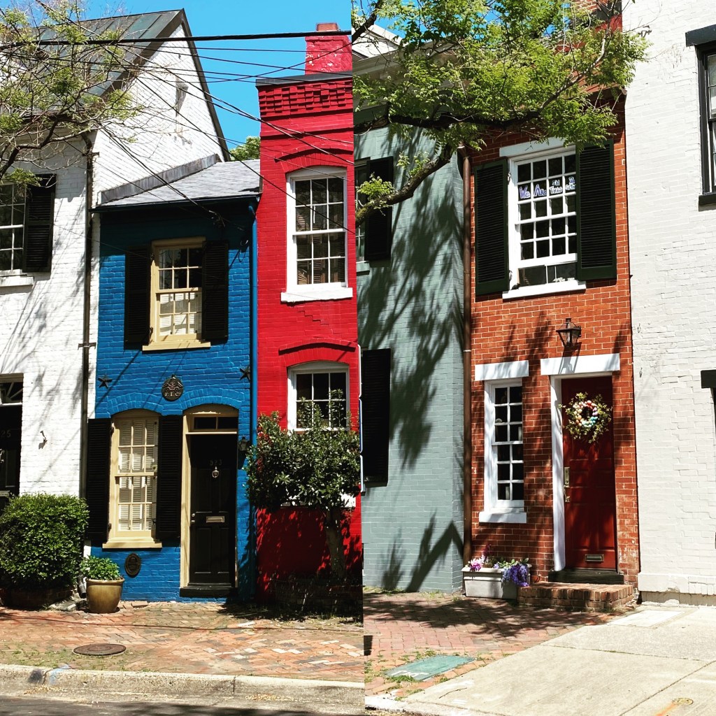
The article cites the Spite House’s 7-foot width. It’s actually wider than that. How do we know? We freakin’ walked over and measured it one day. It’s 7′ 6.5″ wide.
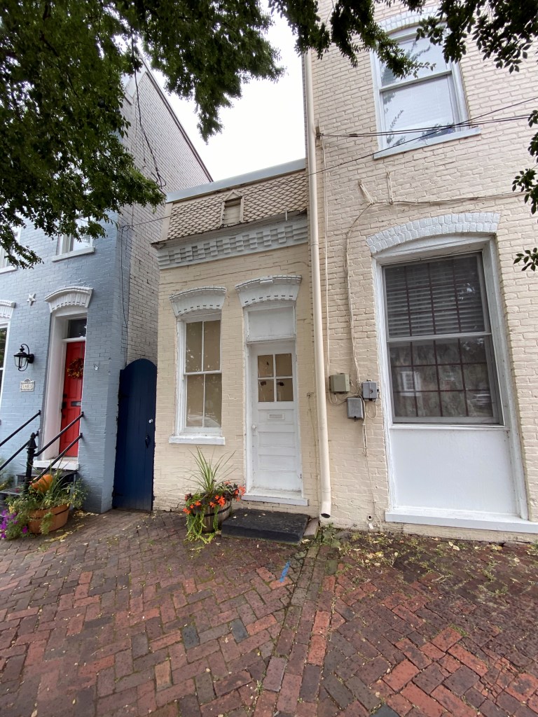
We measured it because we were convinced the tiny house closer to us on Prince Street was actually narrower and should be getting the spotlight that was always the freakin’ Spite House. Here’s the Prince Street house:
It clocks in at 8′ 1.5″ wide. Wider than Hollensbury’s house by 7 inches. We’re surprised and annoyed, but numbers don’t lie.
Here they are, side by side:
Unlike the Spite House, the house on Prince wasn’t built out of spite, but as a means to generate rent revenue. According to our copy of “Historic Alexandria Virginia Street by Street: A Survey of Existing Early Buildings” the house was “built before 1883, when Samuel H. Janney bequeathed to his son, Henry, the rents accruing from ‘the three-story brick house and the small two-story brick house adjoining thereto on the northwest corner of Prince and Royal.'”
Although the little Prince (Street) wasn’t built out of spite, it does share an attribute with the Spite House that few other town houses in Old Town do – it’s an alley house. A house built in what previously was a narrow alley between two larger houses, and that may use one or both sides of the houses on either side of the alley, instead of having independent sides, separate from the other houses.
This was brought to our attention in this article last week by Sarah Dingman in Alexandria Living magazine, which identified this as one of only three other alley houses in Old Town, in addition to the Instagram favorite, the Spite House.
Another of the alley houses can be found 11 blocks west of the little guy above, on the 1400 block of Prince Street:
“It is unique from the other spite houses in that it is only one story tall. The home is a little more than 8-feet wide and has been incorporated into the home next to it.
The same color as the building to the east — the rear of 131 S. West St., which houses Christ House — it almost blends in. It also looks like a miniature replica of the buildings to its left. Note in the photo below the similar framing above the front door and window.
This alley house is the youngest alley house, built between 1891 and 1895 according to Sanborn Fire Insurance maps.”
The final alley house is a boutique shop on the 200 block of King, right in the middle of the shopping and restaurant district:
“Only a couple blocks up from the water, it is commonly passed by but not noticed as one of the alley houses. [We can vouch for this.]
This alley house is relatively wide, measuring 11 feet wide (as measured by Old Town Home blog). The house was built around 1812.
In 1994 the residence, which was located above a then-Birkenstock shoe store, was a total of four rooms, including the bathroom and a kitchen, didn’t have space for a washing machine.”